Esta página no es una página oficial de la aplicación ni de su desarrollador, sino una publicación editorial independiente creada con fines informativos y de comentario. Salvo que se indique expresamente lo contrario, ni la aplicación ni su desarrollador están afiliados, respaldados, patrocinados, autorizados ni conectados oficialmente con MWM, Apple, Google Play, el editor de la aplicación ni su desarrollador, y nada en esta página implica que la aplicación haya sido desarrollada utilizando los servicios de MWM. Todas las marcas comerciales, logotipos, capturas de pantalla y demás contenidos son propiedad de sus respectivos propietarios.

WingX®
Mejora tu conciencia situacional con la galardonada Visión Sintética, el clima ADS-B en tiempo real y la planificación de vuelos avanzada. La opción de confianza para la Aviación General, que ofrece un rendimiento premium y suscripciones gratuitas exclusivas para pilotos VFR y militares.
Descargas
116K+Valoración
Total valoraciones
1K+Editor
Categoría
NavigationIdiomas
1Última versión
9.2.6.206Tamaño
80.4 MBFecha de lanzamiento
30 jun 2010Navegación de Precisión para el Piloto Profesional
Experimenta una Electronic Flight Bag (EFB) rica en funciones, diseñada para mejorar la seguridad y la eficiencia, desde la planificación previa al vuelo hasta la aproximación final.
Conciencia Situacional de Próxima Generación
Vuela con confianza utilizando la Visión Sintética, las alertas de terreno GPWS y la superposición de tráfico y clima ADS-B en tiempo real en un mapa móvil de alto rendimiento.
Valor Enfocado en Militares y VFR
Accede a herramientas de aviación líderes en la industria con niveles de suscripción gratuitos dedicados para personal militar activo o retirado y pilotos solo VFR.
Las siguientes capturas de pantalla y la descripción provienen directamente del listado oficial de la tienda de la aplicación y son propiedad del desarrollador.
App Store
Capturas
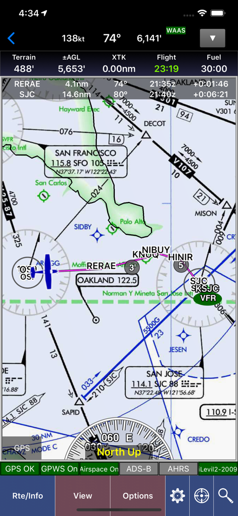
Mapa de navegación de aviación WingX que muestra datos de vuelo y cartas seccionales sobre el área de San Francisco.
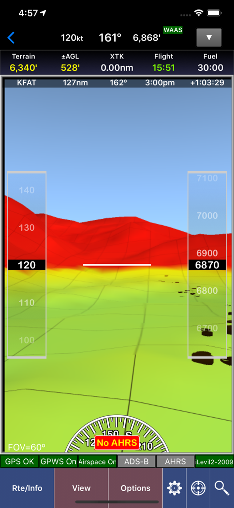
Captura de pantalla de la aplicación WingX que muestra visión sintética con mapeo de terreno 3D y superposiciones de instrumentos de vuelo
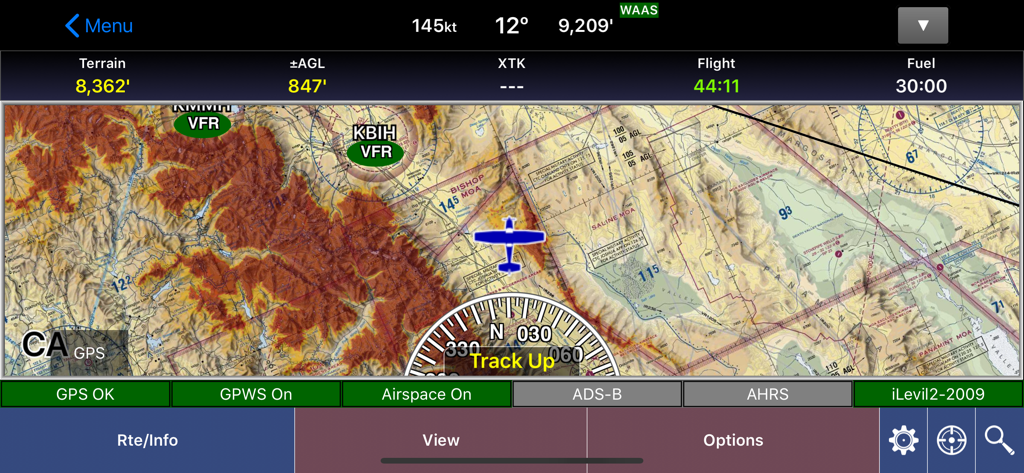
Interfaz de mapa móvil de la aplicación de aviación WingX que muestra detalles del terreno y datos de vuelo
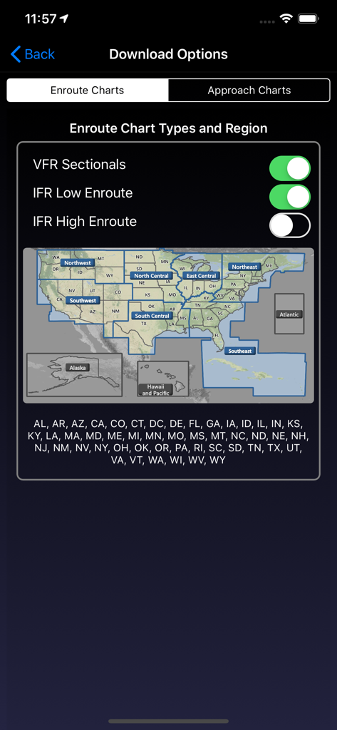
Pantalla de Opciones de Descarga de la aplicación WingX para seleccionar cartas de ruta y regiones de EE. UU.
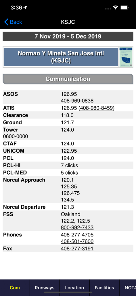
Frecuencias de comunicación de aviación para el Aeropuerto Internacional de San José en la aplicación WingX
Descripción
Download
Apps Similares
Apps con características y experiencia similares

Navigraph Charts
Navigraph KB

SkyDemon
Divelements Limited

Airports
Applicate Ltd

OzRunways EFB
OzRunways Pty. Ltd.

fDeck: flight instruments
Darren Yeates

Noisy Goose
Automata Solutions Ltd.

StationWeather - METAR and TAF
Oliver Puetz

Drone UAV Fly Forecast: AirMap
MONIQ TAP COMPANY LIMITED

Airmate
Myriel Aviation SA
Esta página no es una página oficial de la aplicación ni de su desarrollador, sino una publicación editorial independiente creada con fines informativos y de comentario. Salvo que se indique expresamente lo contrario, ni la aplicación ni su desarrollador están afiliados, respaldados, patrocinados, autorizados ni conectados oficialmente con MWM, Apple, Google Play, el editor de la aplicación ni su desarrollador, y nada en esta página implica que la aplicación haya sido desarrollada utilizando los servicios de MWM. Todas las marcas comerciales, logotipos, capturas de pantalla y demás contenidos son propiedad de sus respectivos propietarios.