Questa pagina non è una pagina ufficiale dell'app o del suo sviluppatore, ma una pubblicazione editoriale indipendente creata a scopo informativo e di commento. Salvo espressa indicazione contraria, né l'app né il suo sviluppatore sono affiliati, approvati, sponsorizzati, autorizzati o altrimenti ufficialmente collegati a MWM, Apple, Google Play, all'editore dell'app o allo sviluppatore dell'app, e nulla in questa pagina implica che l'app sia stata sviluppata utilizzando i servizi di MWM. Tutti i marchi, loghi, screenshot e altri contenuti rimangono di proprietà dei rispettivi proprietari.

i-Boating:HD Gps Marine Charts
Naviga con sicurezza utilizzando carte NOAA ad alta definizione, batimetria da 1 piede per una pesca di precisione e routing vocale in tempo reale, tutto sul dispositivo che già possiedi.
Download
15K+Valutazione
Valutazioni totali
200Editore
Categoria
SportsLingue
8Ultima versione
154.0.0Dimensione
48.6 MBData di lancio
20 mar 2017Naviga con Fiducia Professionale
Trasforma il tuo dispositivo mobile in un chartplotter di livello professionale. Dalla batimetria ad alta definizione per i pescatori al routing vocale per i croceristi, ottieni la precisione di cui hai bisogno per dominare le acque.
Carte Nautiche Vettoriali HD
Accedi ai dati dettagliati NOAA e USACE con contorni di profondità da 1 piede, perfetti per identificare i punti di pesca ideali e navigare in acque poco profonde con la massima sicurezza.
GPS Nautico Guidato Vocalmente
La prima app nautica con istruzioni vocali. Ricevi avvisi in tempo reale per i marcatori di rotta e avvisi di uscita rotta senza mai distogliere lo sguardo dall'orizzonte.
Gli screenshot e la descrizione seguenti provengono direttamente dall'elenco ufficiale dello store dell'app e sono di proprietà dello sviluppatore.
App Store
Screenshot
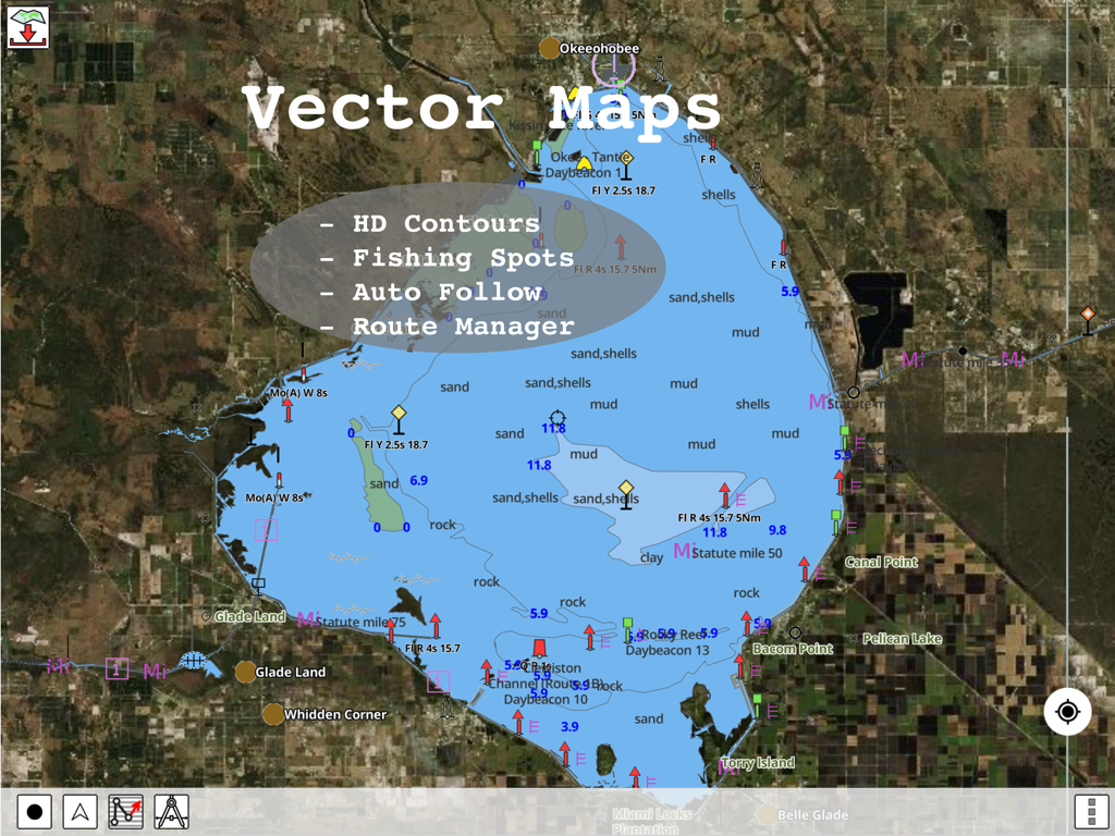
Carte nautiche vettoriali HD con contorni di profondità e punti di pesca nell'app i-Boating
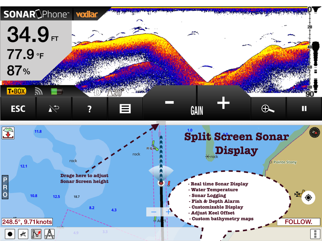
Vista a schermo diviso dell'app i-Boating che mostra dati sonar in tempo reale e carte di navigazione nautica su un iPad.
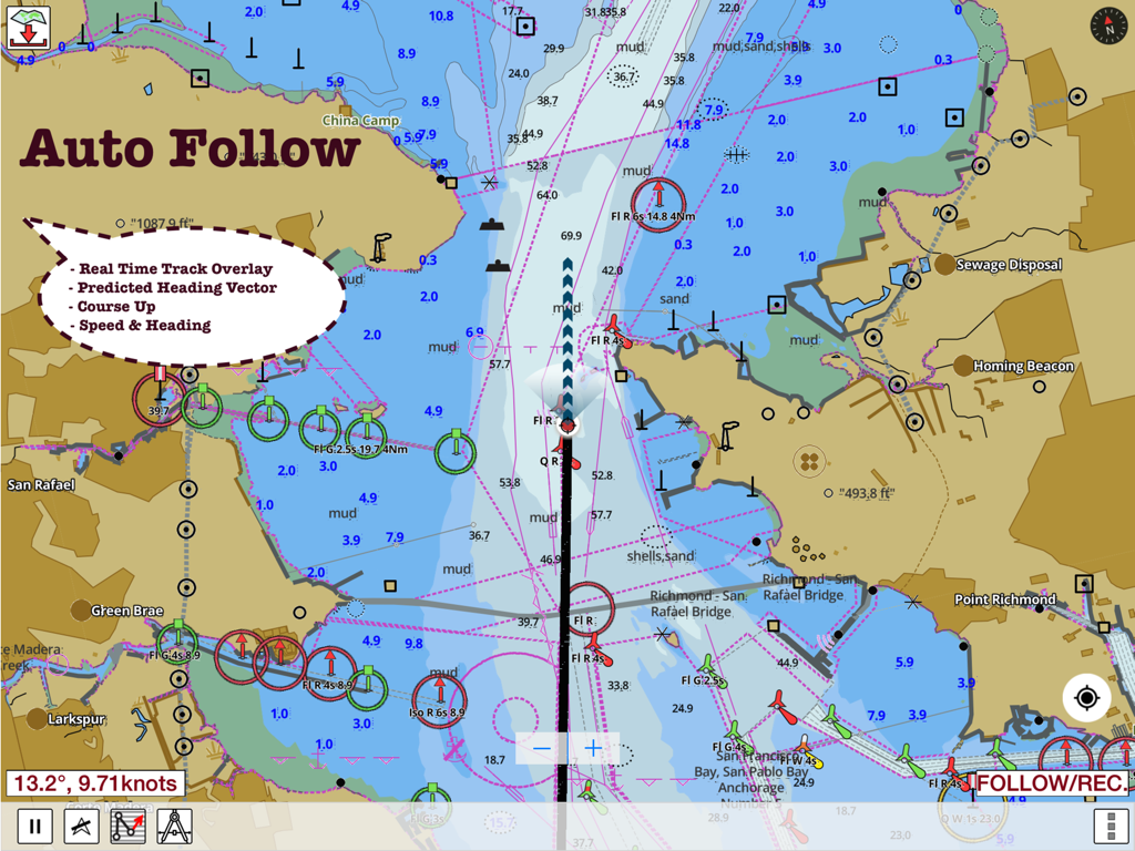
Schermata dell'app i-Boating che mostra la carta nautica con auto-follow e dati di navigazione in tempo reale
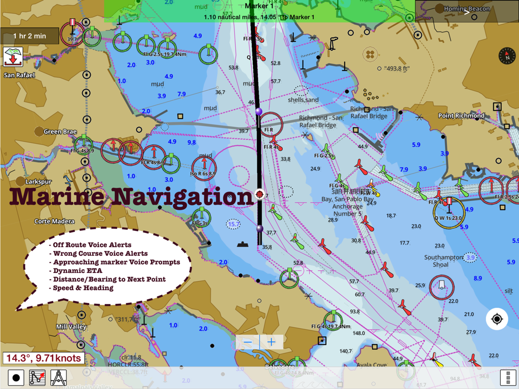
Mappa nautica dettagliata nell'app i-Boating con assistenza alla rotta e avvisi vocali di navigazione nautica.
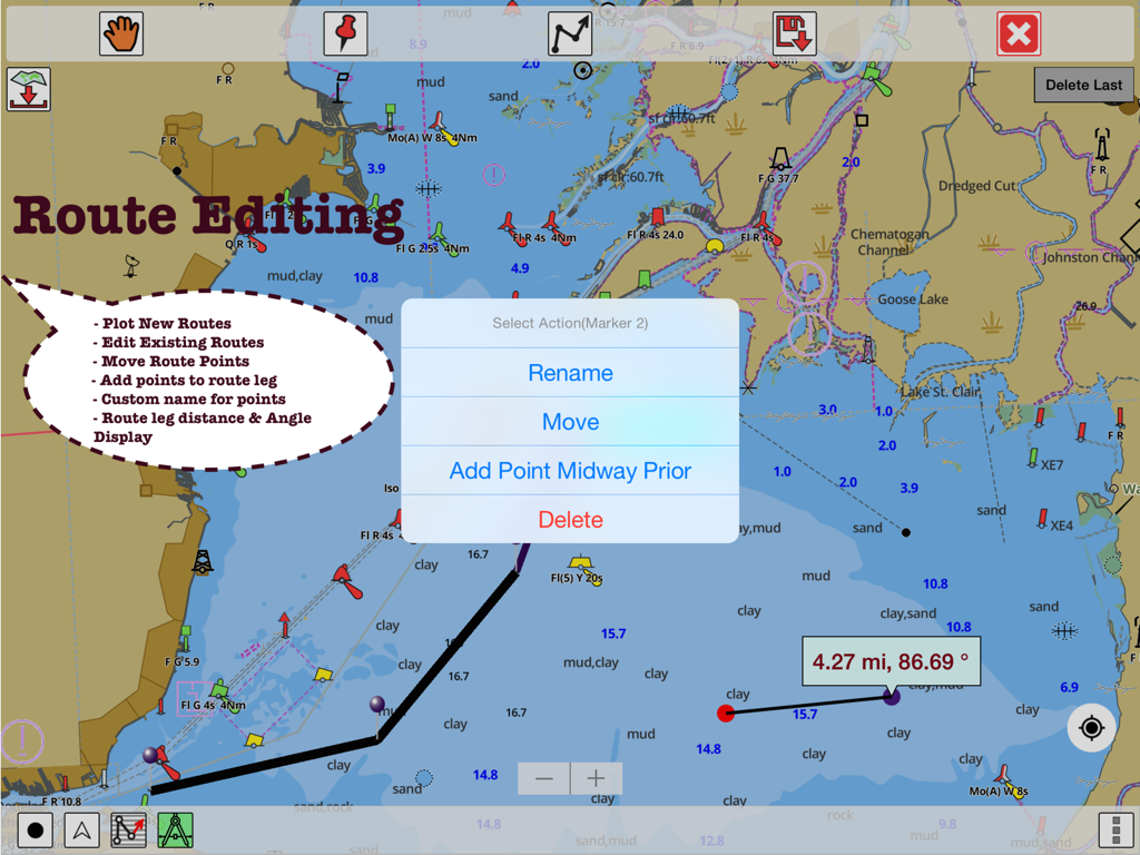
Interfaccia dell'app i-Boating che mostra le funzionalità di modifica del percorso e le misurazioni di distanza su una carta GPS nautica
Descrizione
Download
App Simili
App con funzionalità ed esperienza simili

PredictWind — Marine Forecasts
PredictWind Limited

Navily
The Navigation Family

Argo - Boating Navigation
Argo Navigation, LLC

SEAiq Pilot
Sakhalin, LLC

Maptrails
Pasi Salenius

KartenWerft NavGo 2.0
KartenWerft GmbH

MarineTraffic - Ship Tracking
MARINETRAFFIC APPLICATIONS LTD

Wavve Boating: Marine Boat GPS
Wavve Boating Inc

Savvy Navvy Boating Navigation
SAVVY NAVVY LTD
Questa pagina non è una pagina ufficiale dell'app o del suo sviluppatore, ma una pubblicazione editoriale indipendente creata a scopo informativo e di commento. Salvo espressa indicazione contraria, né l'app né il suo sviluppatore sono affiliati, approvati, sponsorizzati, autorizzati o altrimenti ufficialmente collegati a MWM, Apple, Google Play, all'editore dell'app o allo sviluppatore dell'app, e nulla in questa pagina implica che l'app sia stata sviluppata utilizzando i servizi di MWM. Tutti i marchi, loghi, screenshot e altri contenuti rimangono di proprietà dei rispettivi proprietari.