Questa pagina non è una pagina ufficiale dell'app o del suo sviluppatore, ma una pubblicazione editoriale indipendente creata a scopo informativo e di commento. Salvo espressa indicazione contraria, né l'app né il suo sviluppatore sono affiliati, approvati, sponsorizzati, autorizzati o altrimenti ufficialmente collegati a MWM, Apple, Google Play, all'editore dell'app o allo sviluppatore dell'app, e nulla in questa pagina implica che l'app sia stata sviluppata utilizzando i servizi di MWM. Tutti i marchi, loghi, screenshot e altri contenuti rimangono di proprietà dei rispettivi proprietari.

PRO CHARTS - Marine Navigation
Trasforma il tuo iPhone o iPad in un chartplotter ad alta risoluzione con mappe NOAA offline, facile pianificazione di rotte e tracciamento in tempo reale degli amici, senza bisogno di segnale cellulare.
Download
609K+Valutazione
Valutazioni totali
13K+Editore
Categoria
NavigationLingue
22Ultima versione
5.70Dimensione
45.0 MBData di lancio
4 ago 2011Naviga Come un Capitano Professionista
Trasforma il tuo iPhone o iPad in un GPS marino ad alte prestazioni con carte NOAA professionali e funzionalità di sicurezza avanzate.
Carte NOAA ad Alta Risoluzione
Accedi a carte nautiche ufficiali ad alto dettaglio con dati di profondità per tutte le acque costiere statunitensi e i principali sistemi fluviali.
Navigazione Offline Affidabile
Progettato per funzionare senza segnale cellulare. Pre-carica le tue carte e naviga in mare aperto con totale fiducia.
Gli screenshot e la descrizione seguenti provengono direttamente dall'elenco ufficiale dello store dell'app e sono di proprietà dello sviluppatore.
App Store
Screenshot

Interfaccia di navigazione nautica dell'app PRO CHARTS che mostra una dettagliata carta NOAA con posizione della barca e dati di profondità
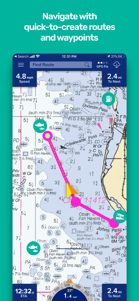
Un'interfaccia di carta nautica che mostra una rotta di navigazione pianificata con waypoint e statistiche di navigazione.
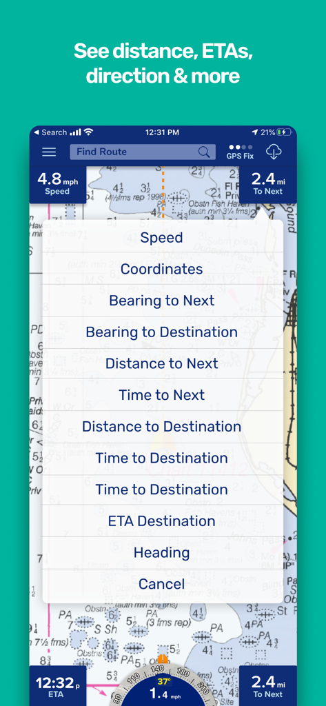
Interfaccia di carta nautica che mostra le opzioni di dati di navigazione tra cui velocità, rilevamento e tempo stimato di arrivo
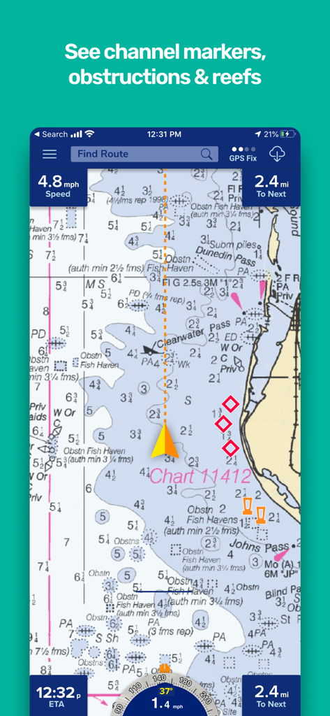
Interfaccia di carta nautica che mostra i marcatori dei canali e i dati di navigazione costiera
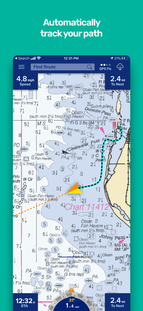
App Pro Charts che mostra un percorso di navigazione tracciato su una mappa di navigazione nautica
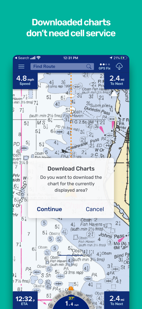
Interfaccia dell'app di navigazione marina che mostra una carta nautica e una richiesta per scaricare le mappe per l'uso offline senza servizio cellulare
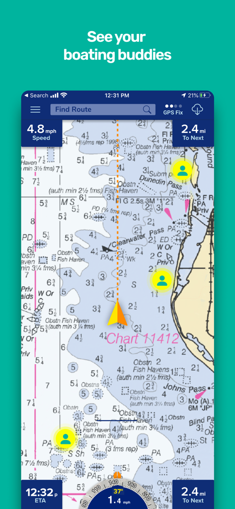
Interfaccia dell'app di navigazione marina Pro Charts che mostra la funzione di tracciamento degli amici su una carta nautica
Descrizione
Download
App Simili
App con funzionalità ed esperienza simili

PredictWind — Marine Forecasts
PredictWind Limited

Navily
The Navigation Family

Argo - Boating Navigation
Argo Navigation, LLC

SEAiq Pilot
Sakhalin, LLC

Maptrails
Pasi Salenius

KartenWerft NavGo 2.0
KartenWerft GmbH

MarineTraffic - Ship Tracking
MARINETRAFFIC APPLICATIONS LTD

Wavve Boating: Marine Boat GPS
Wavve Boating Inc

Savvy Navvy Boating Navigation
SAVVY NAVVY LTD
Questa pagina non è una pagina ufficiale dell'app o del suo sviluppatore, ma una pubblicazione editoriale indipendente creata a scopo informativo e di commento. Salvo espressa indicazione contraria, né l'app né il suo sviluppatore sono affiliati, approvati, sponsorizzati, autorizzati o altrimenti ufficialmente collegati a MWM, Apple, Google Play, all'editore dell'app o allo sviluppatore dell'app, e nulla in questa pagina implica che l'app sia stata sviluppata utilizzando i servizi di MWM. Tutti i marchi, loghi, screenshot e altri contenuti rimangono di proprietà dei rispettivi proprietari.