Questa pagina non è una pagina ufficiale dell'app o del suo sviluppatore, ma una pubblicazione editoriale indipendente creata a scopo informativo e di commento. Salvo espressa indicazione contraria, né l'app né il suo sviluppatore sono affiliati, approvati, sponsorizzati, autorizzati o altrimenti ufficialmente collegati a MWM, Apple, Google Play, all'editore dell'app o allo sviluppatore dell'app, e nulla in questa pagina implica che l'app sia stata sviluppata utilizzando i servizi di MWM. Tutti i marchi, loghi, screenshot e altri contenuti rimangono di proprietà dei rispettivi proprietari.

Trail Explorer
Domina il terreno con sorvoli 3D dei sentieri, dashboard meteo in tempo reale e ricognizione guidata dall'IA. Progettato per l'esploratore tech-forward che richiede una pianificazione di precisione per escursioni, arrampicate e ogni altra attività all'aperto.
Download
200Valutazione
Valutazioni totali
0Editore
Categoria
NavigationLingue
1Ultima versione
2.0.2Dimensione
67.3 MBData di lancio
28 set 2022Domina Ogni Terreno
Dalle anteprime dei sentieri in 3D alle raccomandazioni basate sull'IA, ottieni il kit di strumenti high-tech definitivo per escursioni, arrampicate ed esplorazione della natura.
Scoperta AI-Powered
Chiedi alla nostra IA integrata raccomandazioni su misura per le avventure, dalle cascate adatte ai cani alle migliori attrezzature per le cime locali.
Sorvoli Cinematici dei Sentieri
Visualizza l'intero percorso in 3D prima di partire per padroneggiare i profili di elevazione e le sfide tecniche del terreno.
Gli screenshot e la descrizione seguenti provengono direttamente dall'elenco ufficiale dello store dell'app e sono di proprietà dello sviluppatore.
App Store
Screenshot
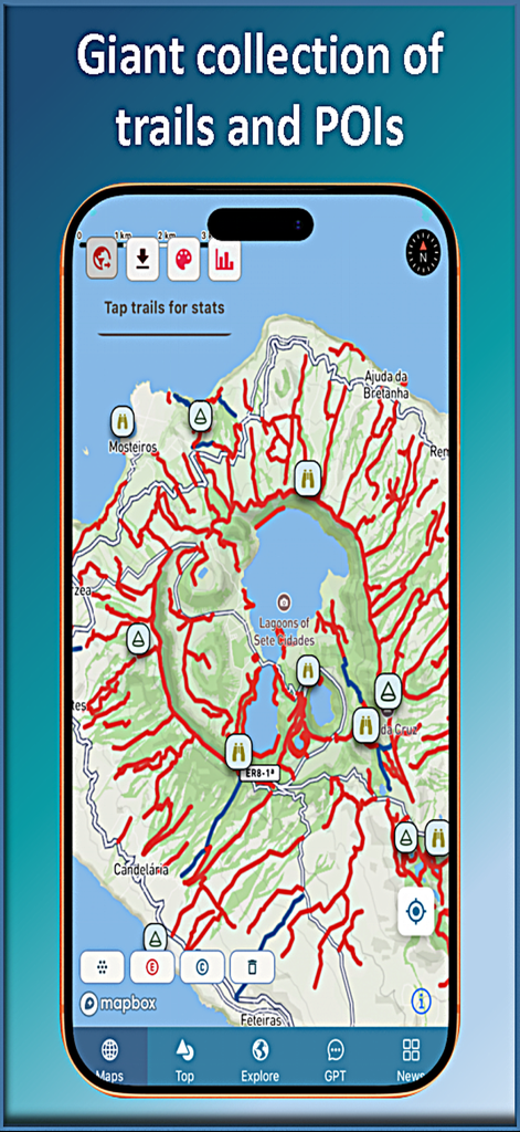
Vista mappa dell'app Trail Explorer che mostra una vasta collezione di sentieri escursionistici e punti di interesse intorno alle Lagune di Sete Cidades.
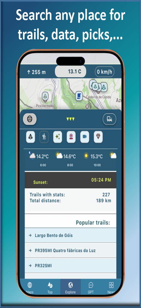
Interfaccia dell'app Trail Explorer che mostra statistiche escursionistiche, previsioni meteo e lista dei sentieri popolari
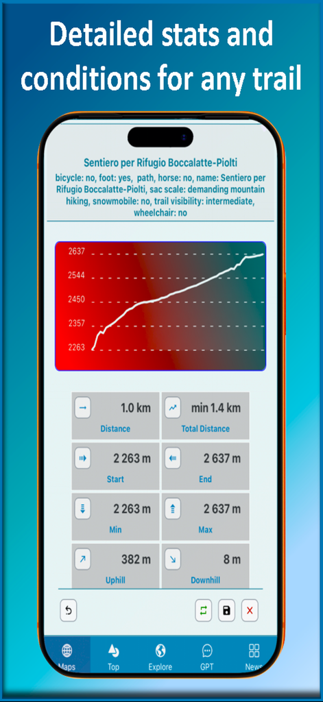
Interfaccia dell'app Trail Explorer che mostra un grafico del profilo altimetrico e statistiche dettagliate sull'escursione
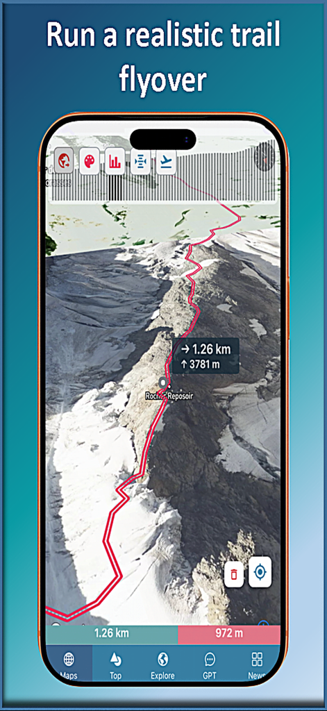
App mobile Trail Explorer che visualizza un sorvolo aereo 3D di un sentiero escursionistico di montagna con dati di elevazione
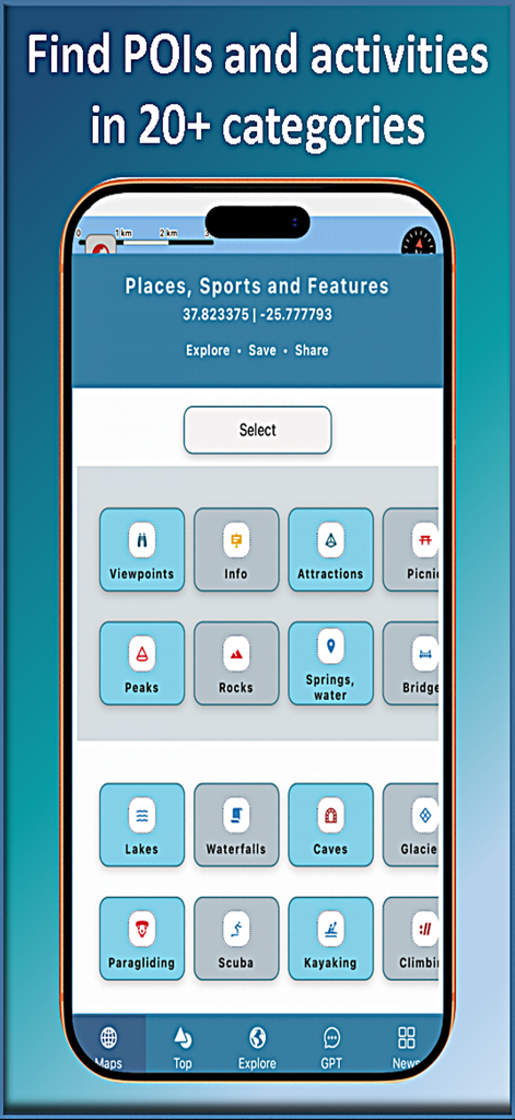
Interfaccia dell'app mobile Trail Explorer che mostra oltre 20 categorie di attività outdoor e punti di interesse tra cui escursionismo, arrampicata e kayak.
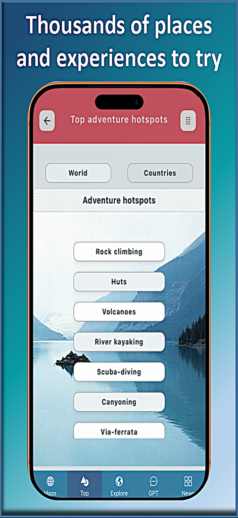
App mobile Trail Explorer che visualizza un elenco di hotspot di avventura e categorie di attività all'aperto
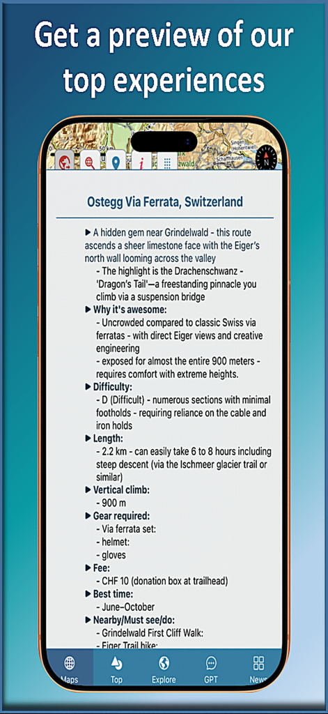
Schermata dello smartphone che mostra dettagli del sentiero come difficoltà e requisiti di equipaggiamento nell'app Trail Explorer

App mobile Trail Explorer che mostra la dashboard in modalità guida con mappa, altitudine, velocità ed elenchi di vette e cascate vicine

Schermata dell'app Trail Explorer che mostra la chat AI che fornisce informazioni locali e luoghi d'interesse per Hilo Hawaii

Feed di notizie dell'app mobile Trail Explorer che mostra articoli di yachting e vela
Descrizione
Download
App Simili
App più classificate nella stessa categoria

Google Maps
Google LLC

Waze Navigation & Live Traffic
waze

AMap Global
AutoNavi Information Technology Co. Ltd.

百度地图-路线规划,出行必备
Beijing Baidu Netcom Science & Technology Co.,Ltd

Moovit: Bus & Transit Tracker
Moovit App Global LTD

Transit • Subway & Bus Times
9280-0366 Quebec inc.

ParkMobile: Park. Pay. Go.
Parkmobile USA, Inc

腾讯地图-路线规划,导航地铁打车出行
Shenzhen Tencent Computer Systems Company Limited

Île-de-France Mobilités
Ile de France Mobilites
Questa pagina non è una pagina ufficiale dell'app o del suo sviluppatore, ma una pubblicazione editoriale indipendente creata a scopo informativo e di commento. Salvo espressa indicazione contraria, né l'app né il suo sviluppatore sono affiliati, approvati, sponsorizzati, autorizzati o altrimenti ufficialmente collegati a MWM, Apple, Google Play, all'editore dell'app o allo sviluppatore dell'app, e nulla in questa pagina implica che l'app sia stata sviluppata utilizzando i servizi di MWM. Tutti i marchi, loghi, screenshot e altri contenuti rimangono di proprietà dei rispettivi proprietari.