Questa pagina non è una pagina ufficiale dell'app o del suo sviluppatore, ma una pubblicazione editoriale indipendente creata a scopo informativo e di commento. Salvo espressa indicazione contraria, né l'app né il suo sviluppatore sono affiliati, approvati, sponsorizzati, autorizzati o altrimenti ufficialmente collegati a MWM, Apple, Google Play, all'editore dell'app o allo sviluppatore dell'app, e nulla in questa pagina implica che l'app sia stata sviluppata utilizzando i servizi di MWM. Tutti i marchi, loghi, screenshot e altri contenuti rimangono di proprietà dei rispettivi proprietari.

WingX®
Migliora la tua consapevolezza situazionale con Visione Sintetica pluripremiata, meteo ADS-B in tempo reale e pianificazione di volo avanzata. La scelta di fiducia per l'Aviazione Generale, che offre prestazioni premium e abbonamenti gratuiti esclusivi per piloti VFR e militari.
Download
116K+Valutazione
Valutazioni totali
1K+Editore
Categoria
NavigationLingue
1Ultima versione
9.2.6.206Dimensione
80.4 MBData di lancio
30 giu 2010Navigazione di Precisione per il Pilota Professionista
Sperimenta un Electronic Flight Bag ricco di funzionalità progettato per migliorare la sicurezza e l'efficienza, dalla pianificazione pre-volo all'avvicinamento finale.
Consapevolezza Situazionale di Prossima Generazione
Vola con fiducia utilizzando la Visione Sintetica, gli avvisi di terreno GPWS e il traffico e le sovrapposizioni meteo ADS-B in tempo reale su una mappa mobile ad alte prestazioni.
Valore Focalizzato su Militari e VFR
Accedi a strumenti di aviazione leader del settore con livelli di abbonamento gratuiti dedicati per personale militare attivo o in pensione e piloti solo VFR.
Gli screenshot e la descrizione seguenti provengono direttamente dall'elenco ufficiale dello store dell'app e sono di proprietà dello sviluppatore.
App Store
Screenshot
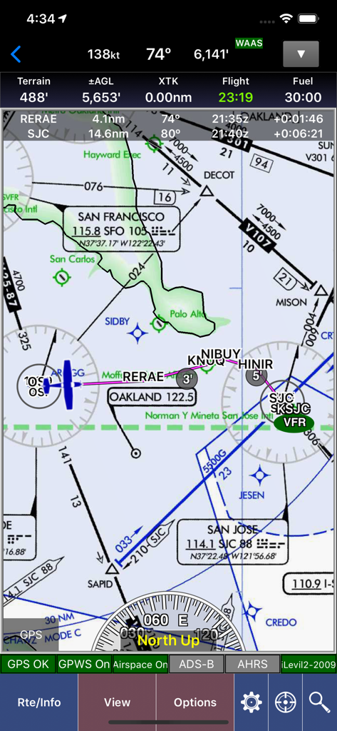
Mappa di navigazione aeronautica WingX che mostra dati di volo e carte sezionali sull'area di San Francisco.
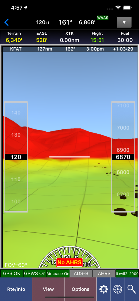
Screenshot dell'app WingX che mostra la visione sintetica con mappatura del terreno 3D e sovrapposizioni di strumenti di volo
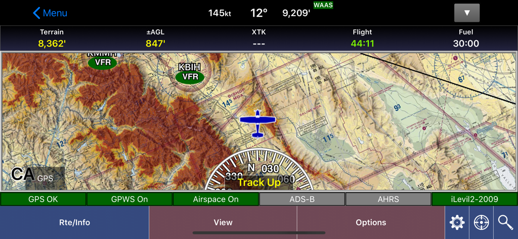
Interfaccia della mappa mobile di navigazione aeronautica WingX che mostra dettagli del terreno e dati di volo
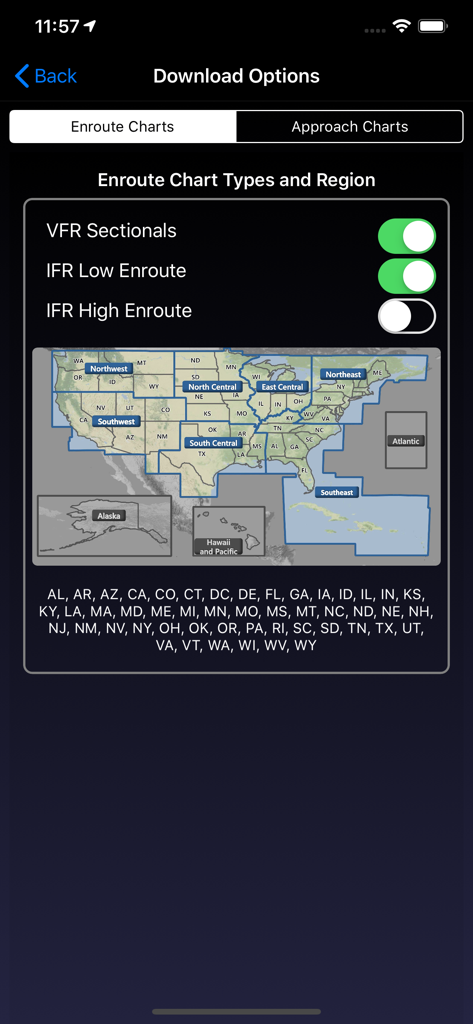
Schermata delle opzioni di download dell'app WingX per selezionare carte di rotta e regioni degli Stati Uniti
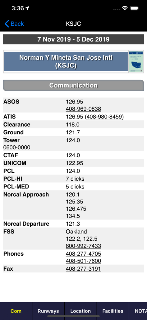
Frequenze di comunicazione aeronautica per l'aeroporto internazionale di San Jose sull'app WingX
Descrizione
Download
App Simili
App con funzionalità ed esperienza simili

Navigraph Charts
Navigraph KB

SkyDemon
Divelements Limited

Airports
Applicate Ltd

OzRunways EFB
OzRunways Pty. Ltd.

fDeck: flight instruments
Darren Yeates

Noisy Goose
Automata Solutions Ltd.

StationWeather - METAR and TAF
Oliver Puetz

Drone UAV Fly Forecast: AirMap
MONIQ TAP COMPANY LIMITED

Airmate
Myriel Aviation SA
Questa pagina non è una pagina ufficiale dell'app o del suo sviluppatore, ma una pubblicazione editoriale indipendente creata a scopo informativo e di commento. Salvo espressa indicazione contraria, né l'app né il suo sviluppatore sono affiliati, approvati, sponsorizzati, autorizzati o altrimenti ufficialmente collegati a MWM, Apple, Google Play, all'editore dell'app o allo sviluppatore dell'app, e nulla in questa pagina implica che l'app sia stata sviluppata utilizzando i servizi di MWM. Tutti i marchi, loghi, screenshot e altri contenuti rimangono di proprietà dei rispettivi proprietari.