Questa pagina non è una pagina ufficiale dell'app o del suo sviluppatore, ma una pubblicazione editoriale indipendente creata a scopo informativo e di commento. Salvo espressa indicazione contraria, né l'app né il suo sviluppatore sono affiliati, approvati, sponsorizzati, autorizzati o altrimenti ufficialmente collegati a MWM, Apple, Google Play, all'editore dell'app o allo sviluppatore dell'app, e nulla in questa pagina implica che l'app sia stata sviluppata utilizzando i servizi di MWM. Tutti i marchi, loghi, screenshot e altri contenuti rimangono di proprietà dei rispettivi proprietari.

Zoom Earth - Weather Forecast
Sperimenta la potenza della meteorologia professionale con splendide mappe interattive e immagini satellitari live. Dal tracciamento di uragani importanti al monitoraggio di incendi, rimani informato e preparato con dati aggiornati ogni 10 minuti.
Download
2M+Valutazione
Valutazioni totali
122K+Editore
Categoria
WeatherLingue
14Ultima versione
5.0.1Dimensione
52.3 MBData di lancio
27 giu 2023Intelligenza Visiva per un Mondo che Cambia
Sperimenta la mappa meteorologica interattiva più avanzata, che combina immagini satellitari ad alta definizione con strumenti di tracciamento di livello professionale per tenerti un passo avanti rispetto agli elementi.
Feed Satellitare Quasi in Tempo Reale
Osserva i modelli meteorologici globali mentre evolvono con immagini HD aggiornate ogni 10 minuti dai satelliti NOAA e NASA, portando dati grezzi direttamente sul tuo schermo.
Tracciamento di Pericoli di Precisione
Proteggi la tua casa e la tua famiglia monitorando uragani, incendi e tempeste violente con gli stessi dati utilizzati dai professionisti della meteorologia e dai soccorritori.
Domande Frequenti
Tutto quello che devi sapere su Zoom Earth - Weather Forecast
Cos'è Zoom Earth - Previsioni Meteo?
Zoom Earth è una mappa meteorologica interattiva e un rilevatore di uragani in tempo reale, che fornisce previsioni per pioggia, vento, temperatura, pressione e altro in tutto il mondo.
Zoom Earth fornisce informazioni meteo in tempo reale?
Sì, Zoom Earth fornisce immagini satellitari quasi in tempo reale aggiornate ogni 10 minuti e rilevamento di pioggia/neve in tempo reale tramite radar Doppler terrestre con nowcasting.
Zoom Earth può monitorare gli uragani in tempo reale?
Sì, Zoom Earth monitora gli uragani dallo sviluppo alla categoria 5 in tempo reale. Si aggiorna utilizzando gli ultimi dati da NHC, JTWC, NRL e IBTrACS.
Zoom Earth mostra incendi boschivi?
Sì, Zoom Earth monitora gli incendi boschivi con una sovrapposizione di incendi attivi e punti caldi, aggiornata quotidianamente con dati da NASA FIRMS. Mostra anche il movimento del fumo degli incendi boschivi.
Quali mappe di previsioni meteorologiche sono disponibili in Zoom Earth?
Zoom Earth offre mappe di previsione per precipitazioni, velocità del vento, raffiche di vento, temperatura, temperatura "percepita", umidità relativa, punto di rugiada e pressione atmosferica.
Come funziona l'abbonamento Zoom Earth PRO?
Zoom Earth PRO offre funzionalità aggiuntive tramite abbonamenti auto-rinnovabili. Il pagamento viene addebitato sul tuo account App Store e si rinnova automaticamente a meno che non venga disattivato 24 ore prima.
Posso personalizzare le impostazioni in Zoom Earth?
Sì, Zoom Earth consente la personalizzazione delle unità di temperatura, unità di vento, fuso orario e stili di animazione attraverso le sue impostazioni complete.
Con quale frequenza vengono aggiornate le immagini satellitari in Zoom Earth?
Le immagini satellitari in tempo reale vengono aggiornate ogni 10 o 15 minuti, a seconda della sorgente satellitare. Le immagini satellitari HD vengono aggiornate due volte al giorno.
Zoom Earth include una mappa radar delle piogge?
Sì, Zoom Earth dispone di una mappa radar meteorologica che mostra pioggia e neve in tempo reale rilevate dal radar Doppler terrestre. Fornisce previsioni meteorologiche istantanee a breve termine.
Posso vedere informazioni sulla velocità del vento su Zoom Earth?
Sì, Zoom Earth fornisce mappe dettagliate di previsione della velocità del vento che mostrano la velocità media e la direzione dei venti superficiali, insieme alle informazioni sulla previsione delle raffiche di vento.
Gli screenshot e la descrizione seguenti provengono direttamente dall'elenco ufficiale dello store dell'app e sono di proprietà dello sviluppatore.
App Store
Screenshot
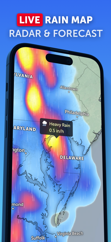
L'app Zoom Earth mostra una mappa delle piogge live con previsioni radar e allerte per piogge intense sulla Costa Est.
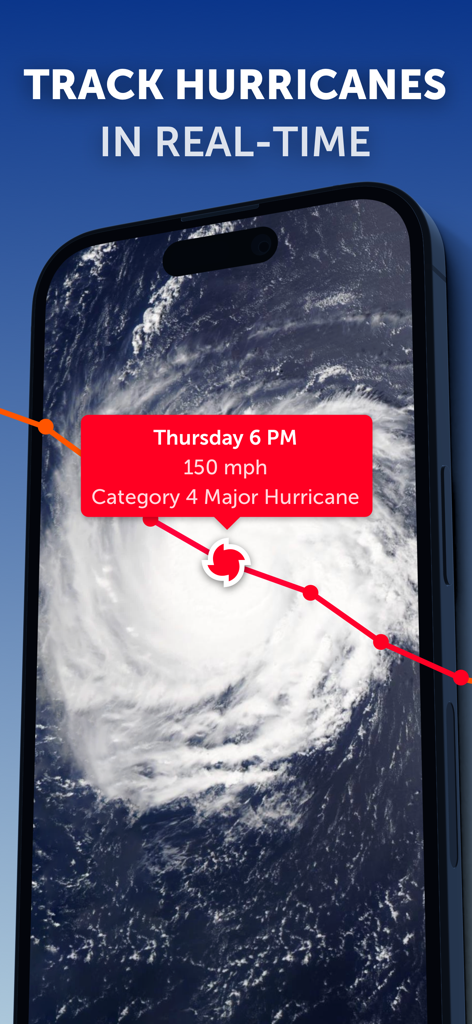
L'interfaccia dell'app Zoom Earth visualizza il tracciamento satellitare in tempo reale e i dati di un uragano di categoria 4.
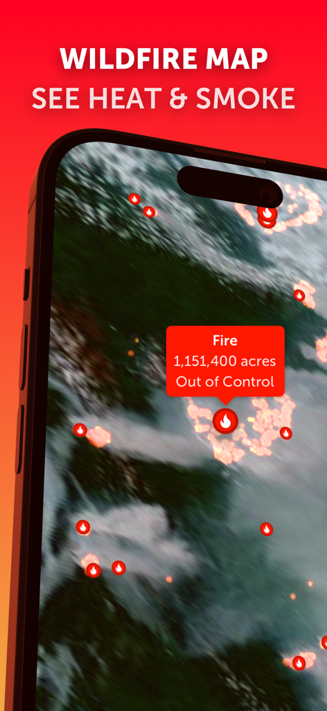
L'app Zoom Earth mostra una mappa degli incendi in tempo reale con punti caldi e dati di incendi fuori controllo.
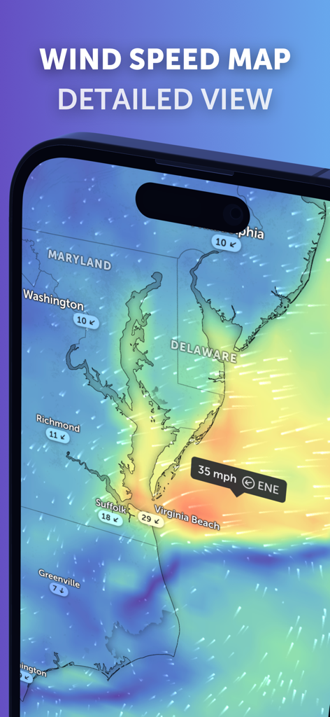
Una dettagliata mappa di previsione della velocità del vento che mostra le condizioni attuali su Maryland e Virginia sull'interfaccia dell'app mobile Zoom Earth.
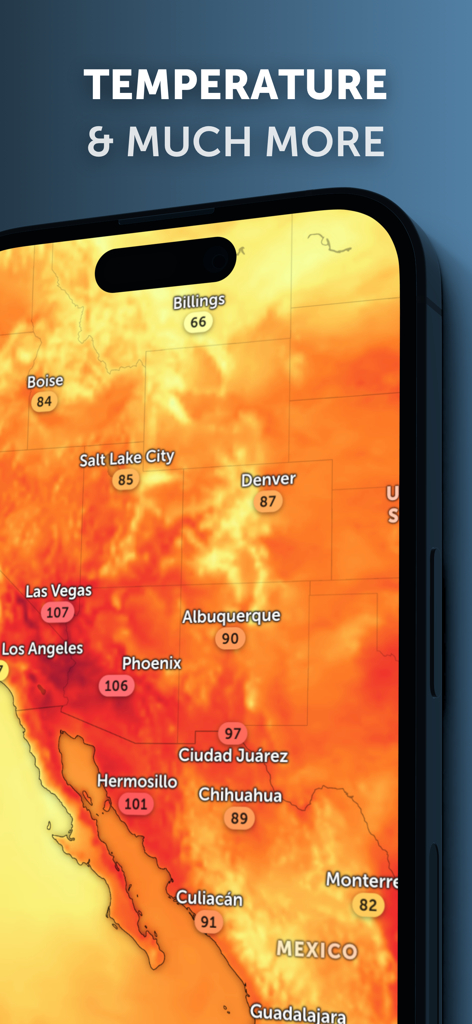
L'app Zoom Earth visualizza una mappa di calore delle temperature del Nord America su uno smartphone.
Descrizione
Download
App Simili
App con funzionalità ed esperienza simili

墨迹天气-MojiWeather
Beijing MojiFengyun Technology Co.,Ltd.

Windy.com
Windyty, SE

天气通
Weibo Internet Technology (China) Co.Ltd.

实时天气-40日精准天气实时预报
犇 牛

MyRadar Accurate Weather Radar
Aviation Data Systems, Inc

Ventusky: Weather & Live Radar
Ventusky s.r.o.

FOX Weather: Daily Forecasts
Fox News Network, LLC

2345天气王-天气和空气质量查询小组件
Shanghai 2345 Network Technology Co., Ltd.

Weather & Widget - Weawow
weawow Inc.
Questa pagina non è una pagina ufficiale dell'app o del suo sviluppatore, ma una pubblicazione editoriale indipendente creata a scopo informativo e di commento. Salvo espressa indicazione contraria, né l'app né il suo sviluppatore sono affiliati, approvati, sponsorizzati, autorizzati o altrimenti ufficialmente collegati a MWM, Apple, Google Play, all'editore dell'app o allo sviluppatore dell'app, e nulla in questa pagina implica che l'app sia stata sviluppata utilizzando i servizi di MWM. Tutti i marchi, loghi, screenshot e altri contenuti rimangono di proprietà dei rispettivi proprietari.