Esta página não é uma página oficial do aplicativo ou de seu desenvolvedor, mas uma publicação editorial independente criada para fins informativos e de comentário. Salvo indicação expressa em contrário, nem o aplicativo nem seu desenvolvedor são afiliados, endossados, patrocinados, autorizados ou oficialmente conectados à MWM, Apple, Google Play, ao editor do aplicativo ou ao desenvolvedor do aplicativo, e nada nesta página implica que o aplicativo foi desenvolvido utilizando os serviços da MWM. Todas as marcas comerciais, logotipos, capturas de tela e outros conteúdos permanecem propriedade de seus respectivos proprietários.

FlyQ+ EFB
Maximize sua consciência situacional com previsão meteorológica 4D, visão sintética 3D e proteção líder do setor contra spoofing de GPS. Projetado para pilotos que exigem uma experiência de cockpit poderosa, porém intuitiva, com fontes maiores e menos toques.
Downloads
116K+Avaliação
Total de avaliações
1K+Editor
Categoria
NavigationIdiomas
1Última versão
7.1.1Tamanho
494.2 MBData de lançamento
24 de out. de 2014Voe Mais Seguro com Clareza Absoluta
O EFB projetado especificamente para o ambiente de cockpit, apresentando interfaces de alta legibilidade e ferramentas de segurança avançadas que minimizam a carga de trabalho e maximizam a consciência situacional.
Interface de Alta Visibilidade
Projetado para o público da Silver Wings com fontes maiores e um layout simplificado que minimiza os toques na tela em condições de voo turbulentas.
Visão Sintética 3D e RA
Experimente 'visão de raio-X' através de nuvens ou à noite com Realidade Aumentada e displays de terreno 3D que transformam a maneira como você vê o mundo ao seu redor.
As capturas de tela e a descrição a seguir são provenientes diretamente da listagem oficial da loja do aplicativo e são propriedade do desenvolvedor.
App Store
Capturas
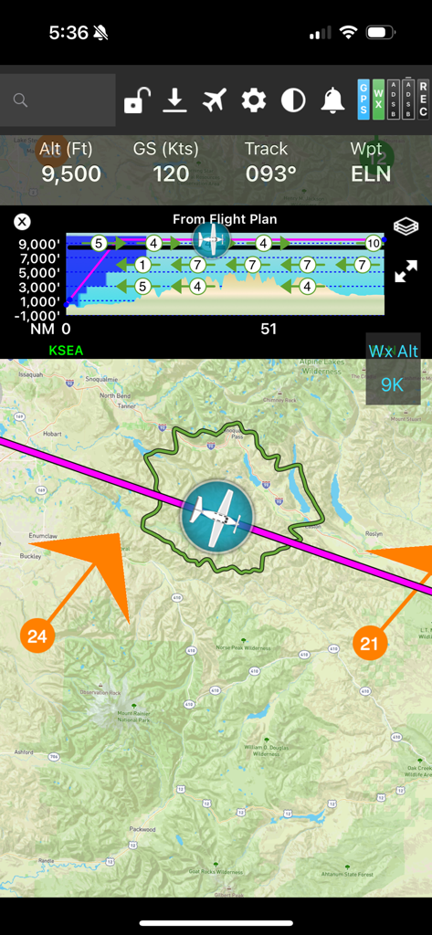
Tela de navegação de voo FlyQ plus EFB mostrando um mapa móvel com um anel de planeio e perfil vertical
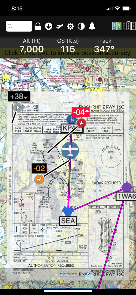
Interface do aplicativo FlyQ+ EFB mostrando uma placa de aproximação RNAV sobreposta a um mapa seccional digital com telemetria de voo
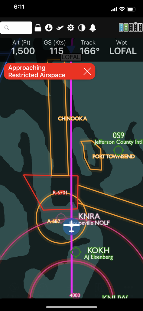
Interface do aplicativo FlyQ plus mostrando um aviso de espaço aéreo restrito em um mapa de voo digital.
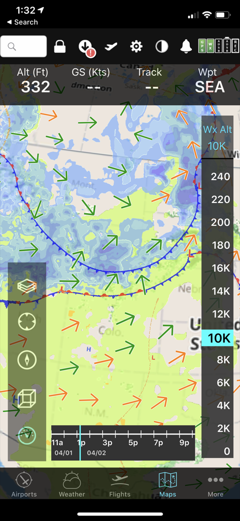
Interface móvel FlyQ+ EFB exibindo um mapa meteorológico preditivo com vetores de vento e controle deslizante de altitude para planejamento de voo.
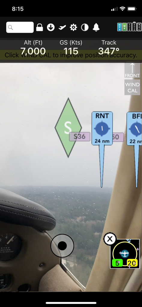
Exibição de navegação de realidade aumentada FlyQ Plus EFB mostrando altitude, velocidade em relação ao solo e marcadores de aeroporto sobre uma visão em tempo real do cockpit

Aplicativo FlyQ plus EFB mostrando estatísticas de voo do piloto e um mapa de voo cênico
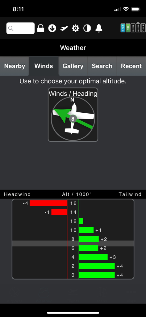
Otimizador gráfico FlyQ Plus EFB mostrando dados de vento de cauda e de proa por altitude
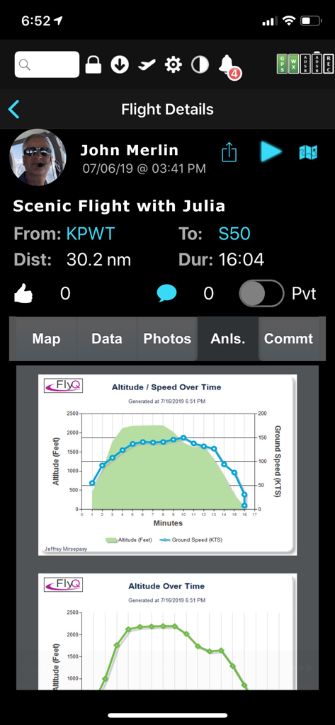
Tela de detalhes de voo FlyQ EFB exibindo gráficos de análise pós-voo para altitude e velocidade em relação ao solo
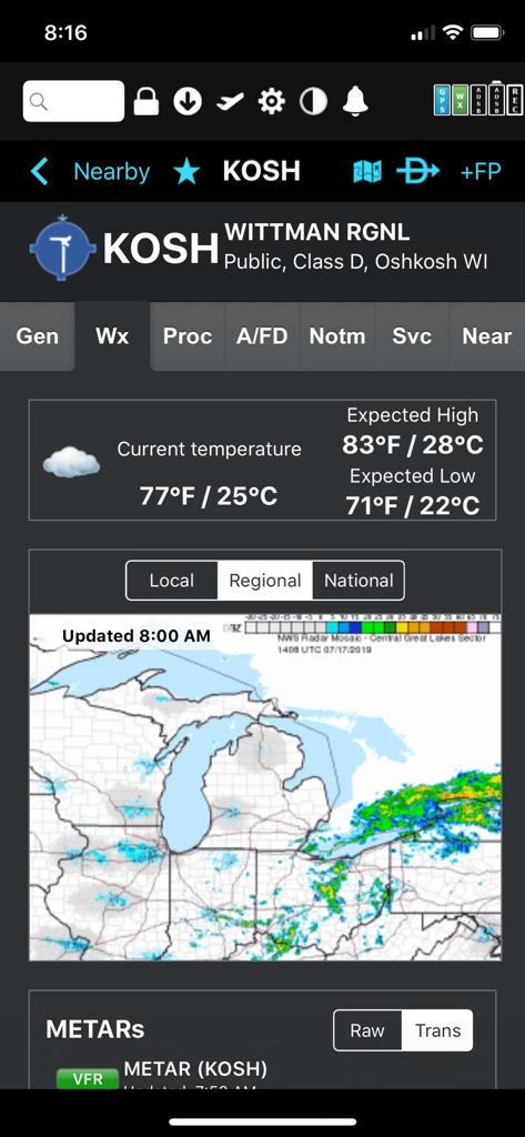
Exibição meteorológica para o Aeroporto Regional de Wittman com temperatura e radar regional no aplicativo FlyQ plus EFB
Descrição
Download
Apps Semelhantes
Apps com recursos e experiência semelhantes

Navigraph Charts
Navigraph KB

SkyDemon
Divelements Limited

Airports
Applicate Ltd

OzRunways EFB
OzRunways Pty. Ltd.

fDeck: flight instruments
Darren Yeates

Noisy Goose
Automata Solutions Ltd.

StationWeather - METAR and TAF
Oliver Puetz

Drone UAV Fly Forecast: AirMap
MONIQ TAP COMPANY LIMITED

Airmate
Myriel Aviation SA
Esta página não é uma página oficial do aplicativo ou de seu desenvolvedor, mas uma publicação editorial independente criada para fins informativos e de comentário. Salvo indicação expressa em contrário, nem o aplicativo nem seu desenvolvedor são afiliados, endossados, patrocinados, autorizados ou oficialmente conectados à MWM, Apple, Google Play, ao editor do aplicativo ou ao desenvolvedor do aplicativo, e nada nesta página implica que o aplicativo foi desenvolvido utilizando os serviços da MWM. Todas as marcas comerciais, logotipos, capturas de tela e outros conteúdos permanecem propriedade de seus respectivos proprietários.