Esta página não é uma página oficial do aplicativo ou de seu desenvolvedor, mas uma publicação editorial independente criada para fins informativos e de comentário. Salvo indicação expressa em contrário, nem o aplicativo nem seu desenvolvedor são afiliados, endossados, patrocinados, autorizados ou oficialmente conectados à MWM, Apple, Google Play, ao editor do aplicativo ou ao desenvolvedor do aplicativo, e nada nesta página implica que o aplicativo foi desenvolvido utilizando os serviços da MWM. Todas as marcas comerciais, logotipos, capturas de tela e outros conteúdos permanecem propriedade de seus respectivos proprietários.
Flyskyhy
Transforme seu dispositivo em um potente GPS-Vario com análise de vento em tempo real, painéis personalizáveis e rastreamento ao vivo. Voe mais longe, com mais segurança e inteligência com mapeamento térmico avançado e proteção de espaço aéreo.
Números Chave
Downloads
198K+
Avaliação
4.4/5
Total de avaliações
600
Editor
Rene Dekker
Categoria
Sports
Idiomas
8
Última versão
9.4
Tamanho
22.6 MB
Data de lançamento
17 de abr. de 2012
Recursos
Eleve a Inteligência do Seu Voo
O padrão ouro para pilotos de parapente e asa delta. Transforme seu iPhone em um cockpit digital de alta precisão projetado para segurança, desempenho e comunidade.
Dados Precisos de Voo
Acesse altitude, velocidade em relação ao solo e intensidade do vento em tempo real. Nosso mapa intuitivo ajuda você a encontrar as térmicas e verificar o alcance de planeio até as zonas de pouso.
Segurança de Espaço Aéreo & Waypoints
Voe com confiança usando dados de espaço aéreo de 30 países. Receba avisos visuais e sonoros para permanecer em conformidade e seguro perto de zonas restritas.
As capturas de tela e a descrição a seguir são provenientes diretamente da listagem oficial da loja do aplicativo e são propriedade do desenvolvedor.
App Store
Capturas
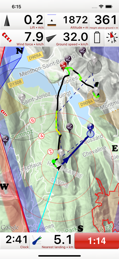
Interface do instrumento de voo do aplicativo Flyskyhy mostrando altitude, velocidade em relação ao solo e mapa em movimento para parapente
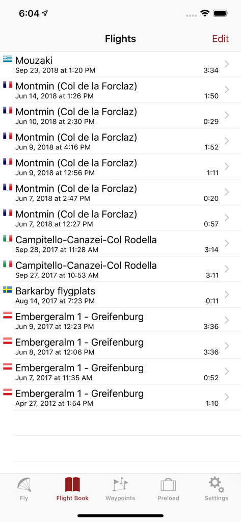
Uma lista de voos de parapente gravados mostrando localização, data e duração no aplicativo Flyskyhy
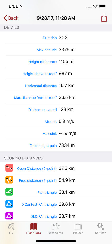
Estatísticas detalhadas do registro de voo e distâncias de pontuação para parapente mostradas no aplicativo Flyskyhy.
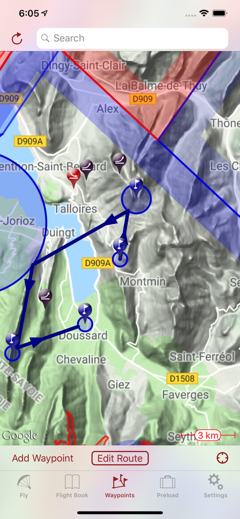
Mapa topográfico no aplicativo Flyskyhy exibindo uma rota de voo planejada com waypoints e espaços aéreos
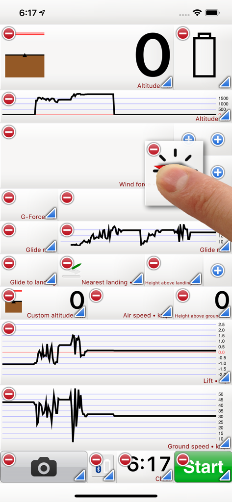
Interface do aplicativo Flyskyhy mostrando widgets e gráficos de dados de voo personalizáveis para pilotos
Descrição
Flyskyhy forms your flight instrument during flight and shows all information you need for that. You get the normal data like altitude, climb rate, ground speed, and glide angle. But it also calculates and shows the current wind direction and strength, very important for your safety.
A moving and rotating map shows your current flying position and flight trail. It indicates where you have gone up (in a thermal), and where you have had faster than normal decline. With that, you can easily find back that thermal that you lost. The map also shows the nearest known landing spots, and whether they are reachable by normal glide, given your current altitude and wind direction.
Integration with Bluetooth varios SensBox, FlyNet, GoFly iPico, XC-Tracer, BlueFlyVario, or SkyDrop gives accurate altitude and lift information. That turns your iPhone into an full-fletched GPS-vario, including vario tones.
The app makes a full log of your flight, that can be analyzed afterwards. Besides normal data like start and landing positions, duration of flight, and an altitude graph of the flight, Flyskyhy also calculates the scoring distances for you. So you can immediately see whether you have broken that FAI triangle record.
Your live location is reported on livetrack24.com or loctome.com if you desire, so anybody can follow your flight while it is happening. If you are flying together with friends, then their location is shown on your map during your flight. So you never have to wonder anymore whether they are in front of or behind you.
The flight display has multiple screens which are all fully configurable. You can move all elements to other spots, delete and add elements, and resize them.
Through in-app purchases, the app also supports airspaces and waypoints.
The app is optimised for paragliding and hang gliders, but can be used with all kinds of airsports.
Main features during the flight;
• Altitude, climb rate, ground speed, air speed, direction, glide angle and many more
• Wind strength and direction
• Moving map of the flying area
• Spots where you have had lift, great for thermal coring
• Shows whether you can still reach a landing spot with the current altitude and wind
• Live tracking of your flight on livetrack24.com or loctome.com
• Shows live location of your friends during flight
After the flight:
• Full logbook of all your flights
• Basic flight data like start/landing, duration, height difference, distance flown, and many more
• Calculation of 5-points, open triangle, and FAI triangle distances
• Graph of altitude and climb rate
• Signed IGC and KML log files of flights
• Transfer the log to iTunes or send by email
• Upload the flight directly to XContest, ParaglidingForum, DHV-XC, and other Leonardo servers
• Open flight in Google Earth on the iPhone
• Replay the flight and relive it!
By purchasing the Waypoints Extension you get access to:
• A fully zoomable and scrollable map with the waypoints and optimised route. The map also shows start and landing spots, as well as restricted airspaces (with the Airspace Extension)
• Enter new waypoints, either on the map or by specifying the parameters
• Full route support with start time, goal, entry/exit points, etc.
• Many instruments to guide you along the route
• Visible and audible indication when a waypoint has been reached
• Complete waypoints organiser
• Import and export of various waypoint file formats
By purchasing the Airspace Extension you get access to:
• Airspaces of 30 countries
• Display of airspaces on the map with configurable colors and formats
• Display of your vertical position w.r.t. airspaces
• Visible and audible warnings when approaching and entering an airspace
• Shows local airspaces by touching a spot on the map
Note: a live internet connection is required for live tracking of your and your friends locations
Note: continuous GPS and screen usage makes the battery drain faster than normal
Esta página não é uma página oficial do aplicativo ou de seu desenvolvedor, mas uma publicação editorial independente criada para fins informativos e de comentário. Salvo indicação expressa em contrário, nem o aplicativo nem seu desenvolvedor são afiliados, endossados, patrocinados, autorizados ou oficialmente conectados à MWM, Apple, Google Play, ao editor do aplicativo ou ao desenvolvedor do aplicativo, e nada nesta página implica que o aplicativo foi desenvolvido utilizando os serviços da MWM. Todas as marcas comerciais, logotipos, capturas de tela e outros conteúdos permanecem propriedade de seus respectivos proprietários.