Cette page n'est pas une page officielle de l'application ou de son développeur, mais une publication éditoriale indépendante créée à des fins d'information et de commentaire. Sauf indication expresse contraire, ni l'application ni son développeur ne sont affiliés, approuvés, sponsorisés, autorisés ou autrement officiellement liés à MWM, Apple, Google Play, à l'éditeur de l'application ou au développeur de l'application, et rien sur cette page n'implique que l'application a été développée en utilisant les services de MWM. Toutes les marques, logos, captures d'écran et autres contenus restent la propriété de leurs propriétaires respectifs.

Fulcrum GIS field data capture
Rationalisez les inspections, le suivi des actifs et les enquêtes avec des applications mobiles alimentées par l'IA. Capturez des données géospatiales précises n'importe où, même hors ligne, et synchronisez-les de manière transparente avec Esri ArcGIS.
Téléchargements
41K+Note
Nombre d'avis
100Éditeur
Catégorie
BusinessLangues
30Dernière version
2601.2.0Taille
162.7 MBDate de sortie
7 oct. 2011Données de terrain de précision, simplifiées
Donnez les moyens à votre équipe avec une solution mobile robuste pour les inspections numériques, le suivi des actifs en temps réel et la cartographie SIG de qualité professionnelle.
Capture fiable des données hors ligne
Ne laissez jamais une zone blanche arrêter votre progression. Capturez des données géolocalisées GPS dans des endroits éloignés et synchronisez-les automatiquement une fois de retour dans une zone couverte.
Saisie vocale mains libres par IA
Résolvez le problème des 'mains sales' avec Audio FastFill. Dictée instantanément les notes et observations du site tout en gardant un œil sur le travail.
Les captures d'écran et la description suivantes proviennent directement de la fiche officielle de l'application sur le store et sont la propriété du développeur.
App Store
Captures
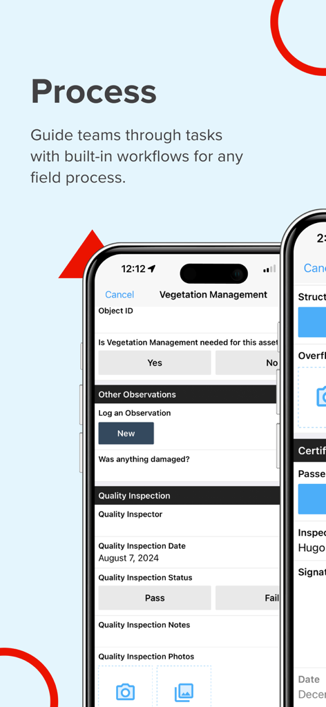
Interface de l'application mobile Fulcrum pour la gestion des flux de travail sur le terrain et des inspections de végétation
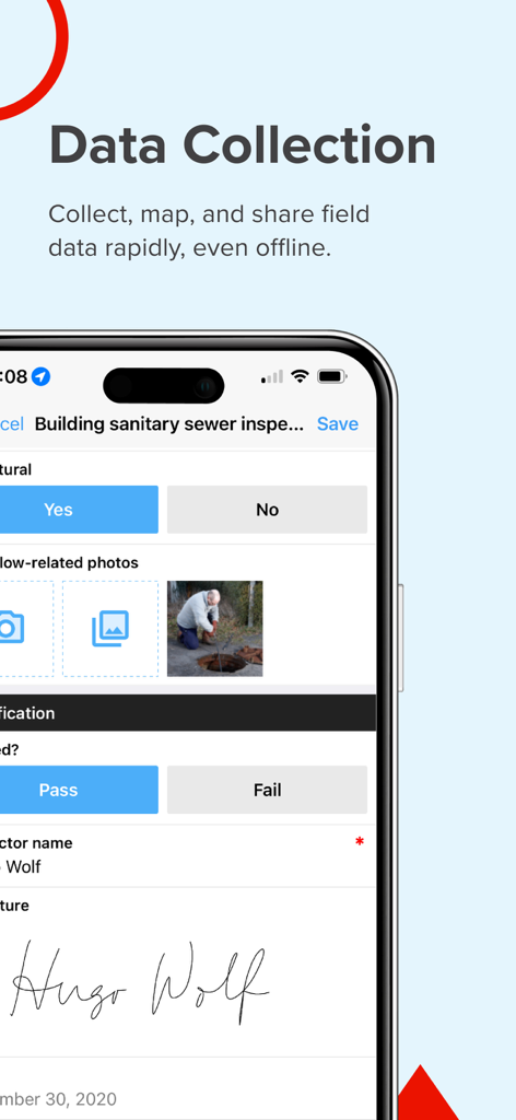
Une interface mobile de l'application Fulcrum montrant un formulaire d'inspection des égouts sanitaires avec une photo de l'ouvrier sur le terrain et une signature numérique.
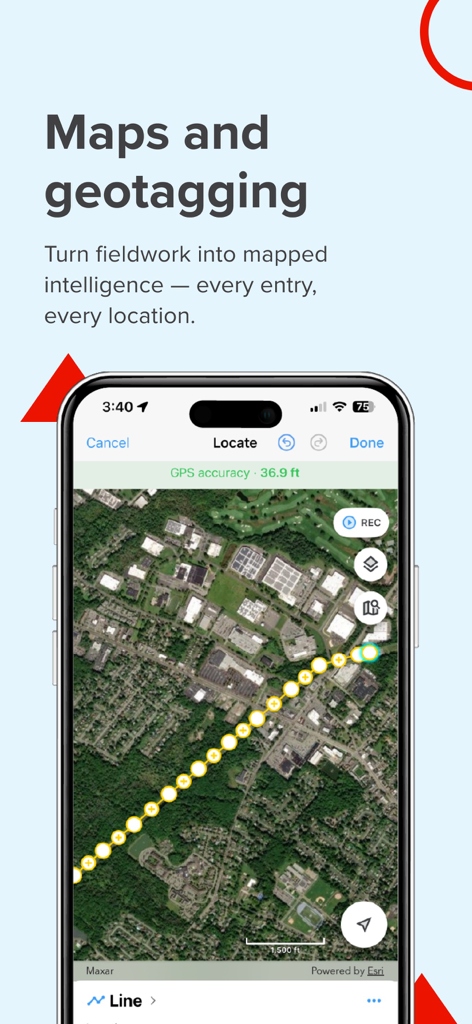
Écran de l'application Fulcrum démontrant la cartographie SIG et la collecte de données de terrain géolocalisées sur une vue satellite.
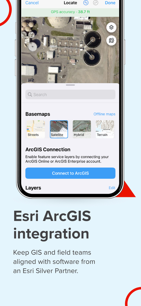
Application mobile Fulcrum montrant l'intégration Esri ArcGIS et les options de cartographie satellite pour les professionnels sur le terrain
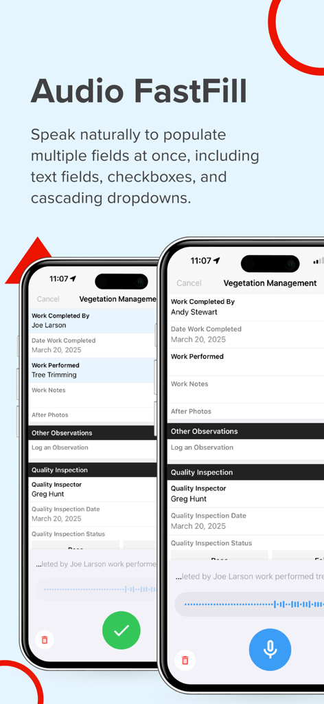
Capture d'écran de l'application Fulcrum présentant Audio FastFill pour la saisie de données vocales alimentée par IA dans les formulaires d'inspection sur le terrain.
Description
Download
Apps Similaires
Apps les mieux classées dans la même catégorie

Microsoft Teams
Microsoft Corporation

Zoom Workplace
Zoom Communications, Inc.

WhatsApp Business
WhatsApp Inc.

Indeed Job Search
Indeed Inc.

LinkedIn: Network & Job Finder
LinkedIn Corporation

Adobe Acrobat Reader: Sign PDF
Adobe Inc.

WeCom-Work Communication&Tools
Tencent Technology (Shenzhen) Company Limited

BOSS直聘-招聘求职找工作神器
Beijing China Product Bo Farce Network Technology Co., Ltd.

DingDing - Redefine Work in AI
DingTalk Technology Co., Ltd.
Cette page n'est pas une page officielle de l'application ou de son développeur, mais une publication éditoriale indépendante créée à des fins d'information et de commentaire. Sauf indication expresse contraire, ni l'application ni son développeur ne sont affiliés, approuvés, sponsorisés, autorisés ou autrement officiellement liés à MWM, Apple, Google Play, à l'éditeur de l'application ou au développeur de l'application, et rien sur cette page n'implique que l'application a été développée en utilisant les services de MWM. Toutes les marques, logos, captures d'écran et autres contenus restent la propriété de leurs propriétaires respectifs.