Diese Seite ist keine offizielle Seite der App oder ihres Entwicklers, sondern eine unabhängige redaktionelle Veröffentlichung, die zu Informations- und Kommentarzwecken erstellt wurde. Sofern nicht ausdrücklich anders angegeben, sind weder die App noch ihr Entwickler mit MWM, Apple, Google Play, dem App-Herausgeber oder dem Entwickler der App verbunden, von ihnen unterstützt, gesponsert, autorisiert oder anderweitig offiziell verbunden, und nichts auf dieser Seite impliziert, dass die App unter Verwendung der Dienste von MWM entwickelt wurde. Alle Marken, Logos, Screenshots und andere Inhalte bleiben Eigentum ihrer jeweiligen Inhaber.

Air Navigation Pro
Beherrschen Sie den Himmel mit professionellen aeronautischen Karten, Echtzeit-Verkehrswarnungen und fortschrittlichen Wetterebenen. Entwickelt für sicherheitsbewusste Piloten, die vom Start bis zur Landung vollständige Situationsübersicht verlangen.
Downloads
523K+Bewertung
Bewertungen gesamt
200Herausgeber
Kategorie
NavigationSprachen
10Neueste Version
8.4.150Größe
213.4 MBErstveröffentlichung
6. Jan. 2009Präzisionsflugwerkzeuge für den modernen Piloten
Verwandeln Sie Ihr iPad in ein professionelles Electronic Flight Bag mit Echtzeit-Situationsübersicht und weltweiten aeronautischen Daten.
3D-Synthetikvision & TAWS
Fliegen Sie mit Vertrauen in jedem Gelände mit hochauflösenden 3D-Ansichten und Terrain Awareness Warning Systems für ultimative Sicherheit.
Integrierter Live-Verkehr
Erhalten Sie Echtzeit-visuelle und akustische Warnungen durch native SafeSky-Integration, um jederzeit über nahegelegene Flugzeuge informiert zu sein.
Die folgenden Screenshots und die Beschreibung stammen direkt aus dem offiziellen Store-Eintrag der App und sind Eigentum des Entwicklers.
App Store
Screenshots
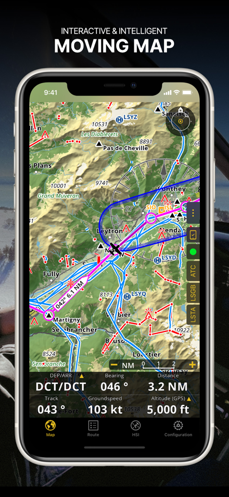
Screenshot der Air Navigation Pro App, der eine interaktive Bewegungskarte mit aeronautischen Karten und Echtzeit-Flugdaten zeigt
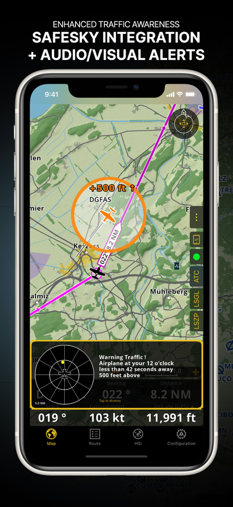
Air Navigation Pro-Oberfläche, die verbesserte Verkehrsüberwachung mit SafeSky-Integration und visuellen Warnungen zeigt
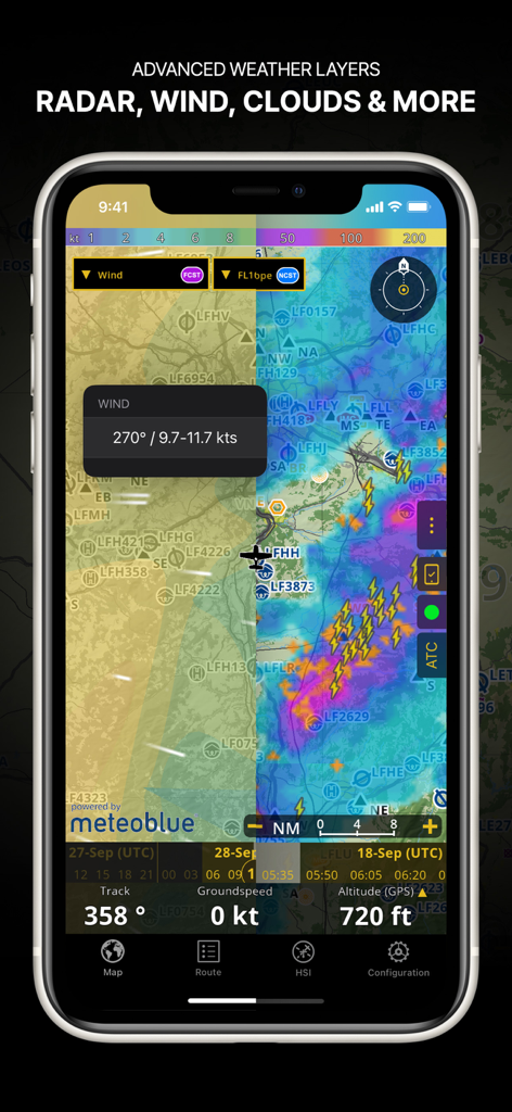
Screenshot der Air Navigation Pro App, der fortschrittliche Wetterebenen wie Radar, Wind und Wolkendecke auf einer Navigationskarte zeigt
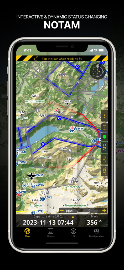
Air Navigation Pro-Oberfläche, die dynamische NOTAM-Informationen auf einer topografischen aeronautischen Karte anzeigt
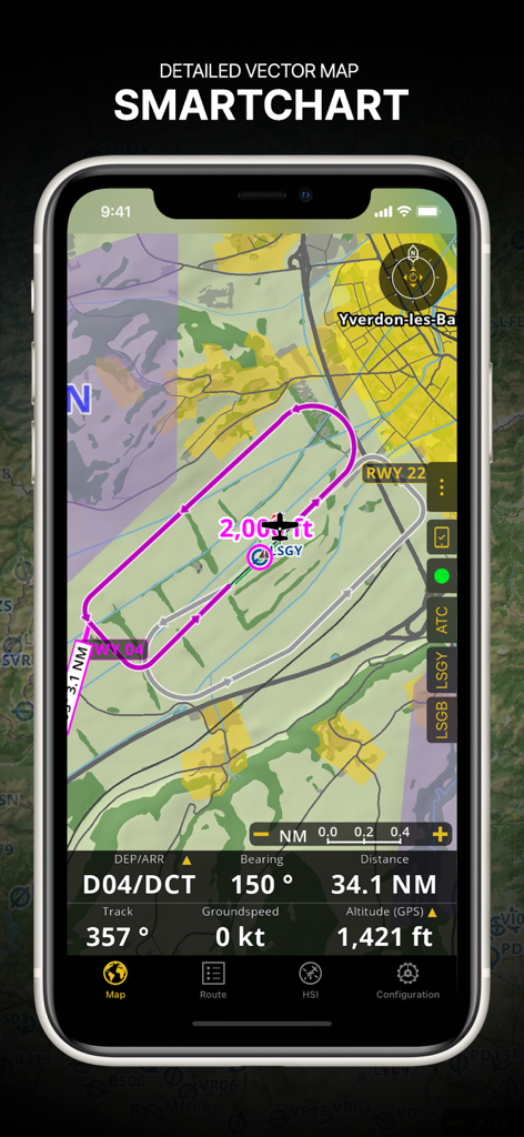
Air Navigation Pro-Oberfläche, die eine detaillierte Vektor-SmartChart mit einer Flugroute und Echtzeit-Navigationsdaten zeigt.
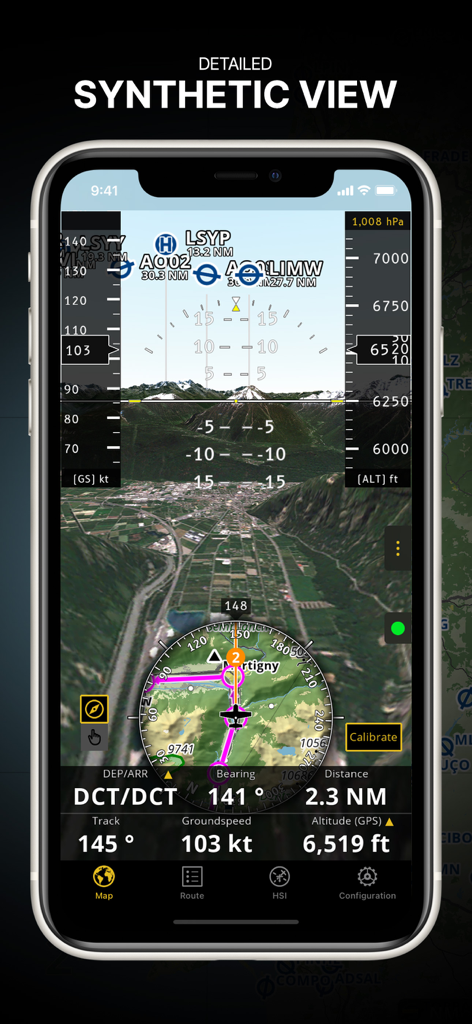
Air Navigation Pro App, die die detaillierte Synthetikansicht mit 3D-Gelände und integrierten Fluginstrumenten anzeigt
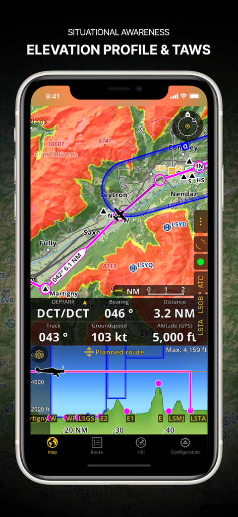
Air Navigation Pro-Screenshot, der das Höhenprofil und das Terrain Awareness Warning System zeigt.
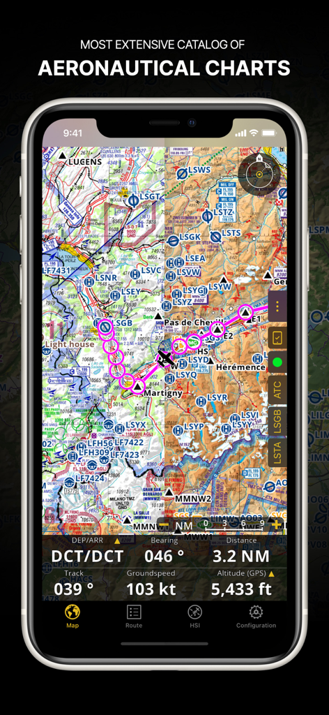
Air Navigation Pro App, die eine detaillierte aeronautische Karte mit Flugroute und Navigationsdaten auf dem Bildschirm eines Smartphones anzeigt
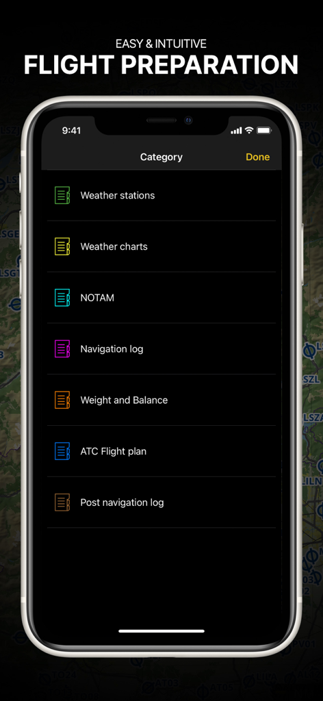
Air Navigation Pro App, die das Flugvorbereitungsmenü mit Briefing-Kategorien für Piloten anzeigt
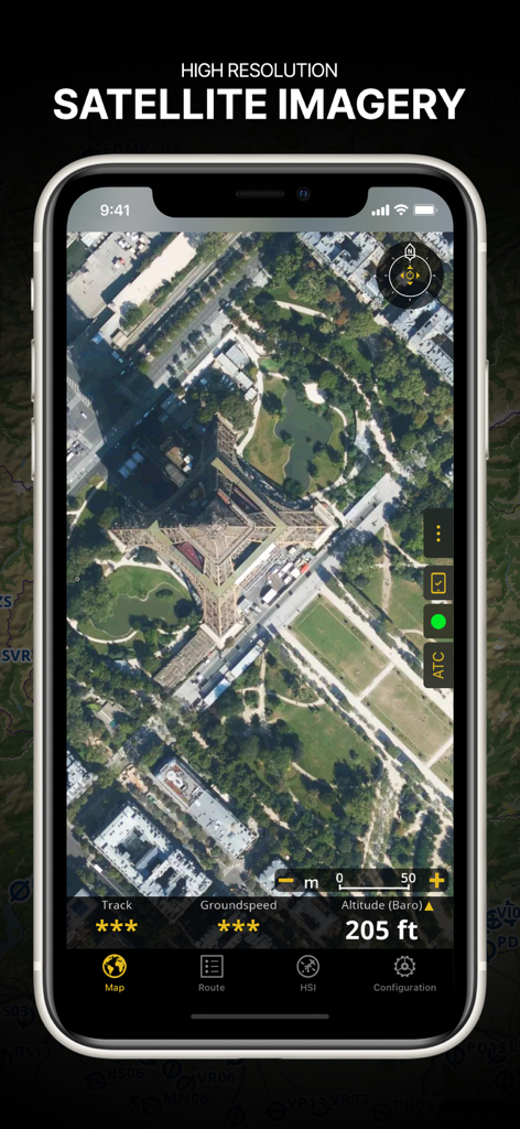
Screenshot der Air Navigation Pro App, die hochauflösende Satellitenbilder des Eiffelturms mit überlagerten Flugdaten zeigt
Beschreibung
Download
Ähnliche Apps
Apps mit ähnlichen Funktionen und Nutzererfahrung

Navigraph Charts
Navigraph KB

SkyDemon
Divelements Limited

Airports
Applicate Ltd

OzRunways EFB
OzRunways Pty. Ltd.

fDeck: flight instruments
Darren Yeates

Noisy Goose
Automata Solutions Ltd.

StationWeather - METAR and TAF
Oliver Puetz

Drone UAV Fly Forecast: AirMap
MONIQ TAP COMPANY LIMITED

Airmate
Myriel Aviation SA
Diese Seite ist keine offizielle Seite der App oder ihres Entwicklers, sondern eine unabhängige redaktionelle Veröffentlichung, die zu Informations- und Kommentarzwecken erstellt wurde. Sofern nicht ausdrücklich anders angegeben, sind weder die App noch ihr Entwickler mit MWM, Apple, Google Play, dem App-Herausgeber oder dem Entwickler der App verbunden, von ihnen unterstützt, gesponsert, autorisiert oder anderweitig offiziell verbunden, und nichts auf dieser Seite impliziert, dass die App unter Verwendung der Dienste von MWM entwickelt wurde. Alle Marken, Logos, Screenshots und andere Inhalte bleiben Eigentum ihrer jeweiligen Inhaber.