Diese Seite ist keine offizielle Seite der App oder ihres Entwicklers, sondern eine unabhängige redaktionelle Veröffentlichung, die zu Informations- und Kommentarzwecken erstellt wurde. Sofern nicht ausdrücklich anders angegeben, sind weder die App noch ihr Entwickler mit MWM, Apple, Google Play, dem App-Herausgeber oder dem Entwickler der App verbunden, von ihnen unterstützt, gesponsert, autorisiert oder anderweitig offiziell verbunden, und nichts auf dieser Seite impliziert, dass die App unter Verwendung der Dienste von MWM entwickelt wurde. Alle Marken, Logos, Screenshots und andere Inhalte bleiben Eigentum ihrer jeweiligen Inhaber.

Detector Maps
Entwickelt von Geologen, um Ihnen zu helfen, Gold zu finden. Greifen Sie auf Live-Schürfrechte, hochauflösendes LiDAR und Offline-GPS-Breadcrumb-Tracking in Australien, den USA und Neuseeland zu.
Downloads
14K+Bewertung
Bewertungen gesamt
0Herausgeber
Kategorie
NavigationSprachen
1Neueste Version
4.0.0Größe
99.5 MBErstveröffentlichung
21. Sept. 2025Gebaut für den modernen Goldgräber
Professionelle geologische Daten und Offline-GPS-Werkzeuge, die Ihnen helfen, Gold zu finden und sich mit absoluter Sicherheit in abgelegenes Gelände zu begeben.
Aktuelle Daten zu Schürfrechten
Schützen Sie Ihren Ruf und vermeiden Sie Geldstrafen mit täglichen Updates zu aktiven Schürflizenzen und Landgrenzen in den USA und Australien.
Präzises Breadcrumb-Tracking
Maximieren Sie Ihre Effizienz, indem Sie Ihren genauen Weg im Hintergrund protokollieren, damit Sie nie wieder Zeit damit verschwenden, Ihren Detektor über denselben Boden schwingen.
Die folgenden Screenshots und die Beschreibung stammen direkt aus dem offiziellen Store-Eintrag der App und sind Eigentum des Entwicklers.
App Store
Screenshots
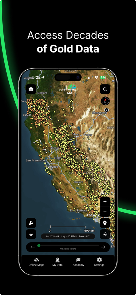
Detector Maps App-Oberfläche zeigt historische Golddatenpunkte auf einer Karte von Kalifornien
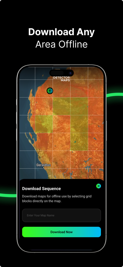
Oberfläche der Detector Maps App zeigt die Auswahl von Rasterblöcken für den Offline-Karten-Download
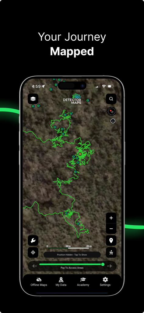
Smartphone-Bildschirm zeigt eine grüne Brotkrümelspur auf einer Karte innerhalb der Detector Maps Gold Prospecting App
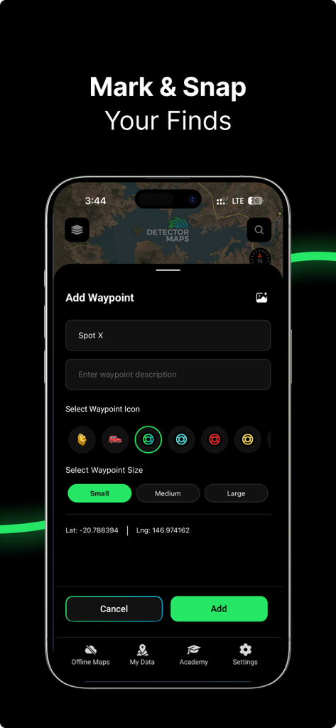
Detector Maps App-Bildschirm zeigt, wie ein Wegpunkt für einen Fund markiert und gespeichert wird.
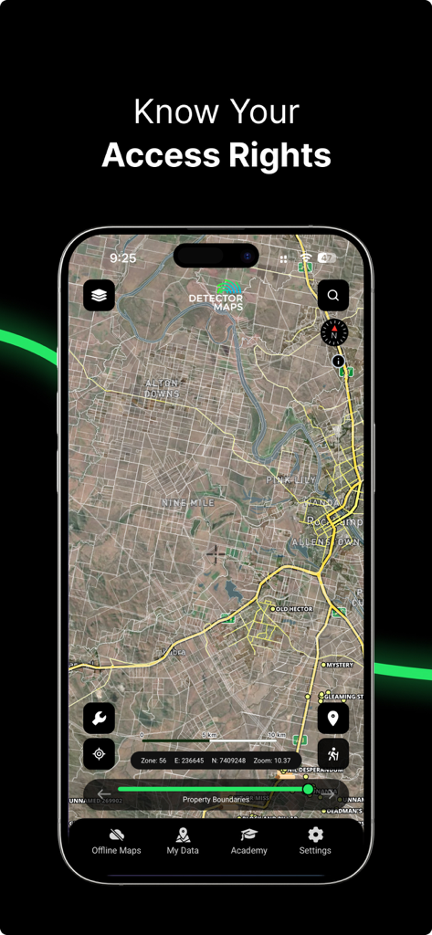
Ein Screenshot einer mobilen App, der Grundstücksgrenzen und Landzugangsrechte auf einer detaillierten Satellitenkarte für Gold Prospecting zeigt
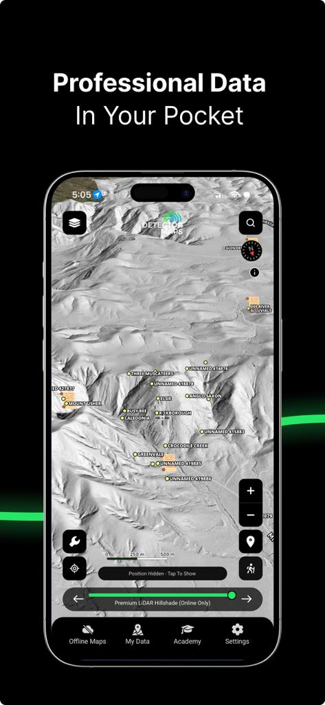
Detector Maps App-Oberfläche zeigt detaillierte LiDAR-Schummerung des Geländes und Standorte von Goldminen
Beschreibung
Download
Ähnliche Apps
Apps mit ähnlichen Funktionen und Nutzererfahrung

LandGlide: Find Property Lines
Real Estate Portal USA, LLC

Regrid Property App
Loveland Technologies, LLC

DealCheck: Analyze Real Estate
Fortnoff Financial LLC

Reventure App
Reventure App LLC

Land id®
MapRight, LLC

Acres: Land Data & Parcel Maps
AcreMaps, LLC

Tapusor
TUVIMER ARGE FAALIYETLERI VE TEKNOLOJI SISTEMLERITICARET ANONIM SIRKETI

Endeksa: Value & Sell Property
Endeksa Teknoloji Anonim Sirketi

Parceled Land Map
Uri Nemirovsky
Diese Seite ist keine offizielle Seite der App oder ihres Entwicklers, sondern eine unabhängige redaktionelle Veröffentlichung, die zu Informations- und Kommentarzwecken erstellt wurde. Sofern nicht ausdrücklich anders angegeben, sind weder die App noch ihr Entwickler mit MWM, Apple, Google Play, dem App-Herausgeber oder dem Entwickler der App verbunden, von ihnen unterstützt, gesponsert, autorisiert oder anderweitig offiziell verbunden, und nichts auf dieser Seite impliziert, dass die App unter Verwendung der Dienste von MWM entwickelt wurde. Alle Marken, Logos, Screenshots und andere Inhalte bleiben Eigentum ihrer jeweiligen Inhaber.