Diese Seite ist keine offizielle Seite der App oder ihres Entwicklers, sondern eine unabhängige redaktionelle Veröffentlichung, die zu Informations- und Kommentarzwecken erstellt wurde. Sofern nicht ausdrücklich anders angegeben, sind weder die App noch ihr Entwickler mit MWM, Apple, Google Play, dem App-Herausgeber oder dem Entwickler der App verbunden, von ihnen unterstützt, gesponsert, autorisiert oder anderweitig offiziell verbunden, und nichts auf dieser Seite impliziert, dass die App unter Verwendung der Dienste von MWM entwickelt wurde. Alle Marken, Logos, Screenshots und andere Inhalte bleiben Eigentum ihrer jeweiligen Inhaber.

Drone Assist - Flight Planning
Schließen Sie sich über 160.000 Piloten an, die die branchenweit vertrauenswürdigste Quelle für Echtzeit-Situationsbewusstsein, Flugverbotszonen-Warnungen und professionelle Flugberichte nutzen.
Downloads
163K+Bewertung
Bewertungen gesamt
1K+Herausgeber
Kategorie
NavigationSprachen
4Neueste Version
2.4.182332Größe
28.7 MBErstveröffentlichung
26. Juli 2017Intelligenter, sicherer und vollkommen konform fliegen
Schließen Sie sich über 160.000 Piloten an, die die vertrauenswürdigste Quelle für Luftraum-Lagebewusstsein in Echtzeit und Flugplanung nutzen.
Sofortige Luftraum-Informationen
Vermeiden Sie kostspielige FAA-Bußgelder und physische Gefahren mit Echtzeitzugriff auf Flugverbotszonen (NFZ), NOTAMs und Risiken am Boden.
Professionelle Missionsplanung
Erstellen, verwalten und übermitteln Sie Flugpläne, um andere Luftraumnutzer zu warnen, und erstellen Sie einen professionellen Nachweis für jede kommerzielle oder private Mission.
Die folgenden Screenshots und die Beschreibung stammen direkt aus dem offiziellen Store-Eintrag der App und sind Eigentum des Entwicklers.
App Store
Screenshots
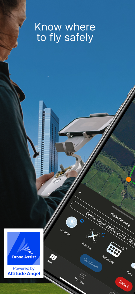
Ein Drohnenpilot verwendet die Drone Assist App für die Flugplanung und Luftraumsicherheitsinformationen auf einem Smartphone, das an einer Fernsteuerung befestigt ist.
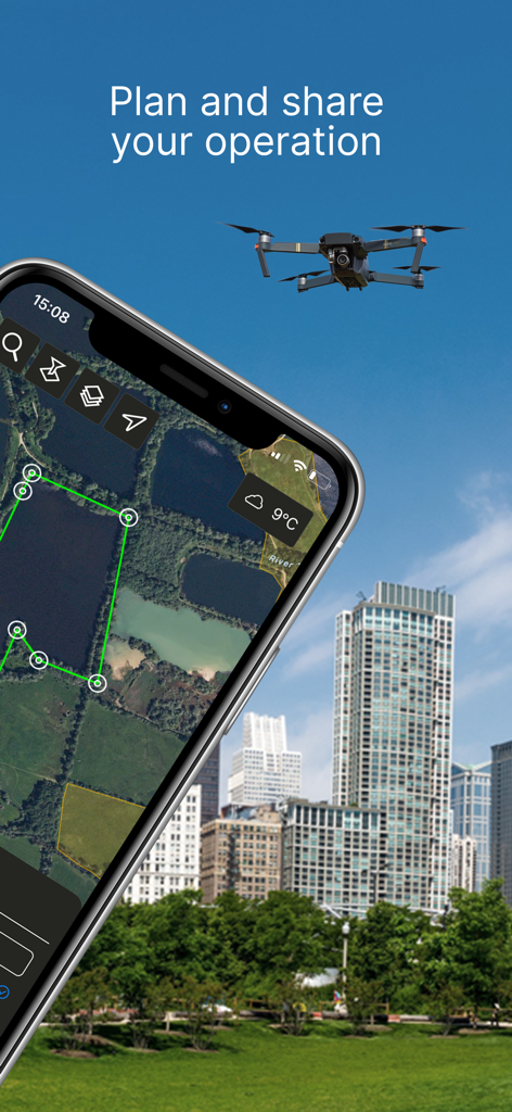
Smartphone zeigt die Benutzeroberfläche der Drone Assist App zur Planung von Drohnenflügen in städtischen Gebieten.
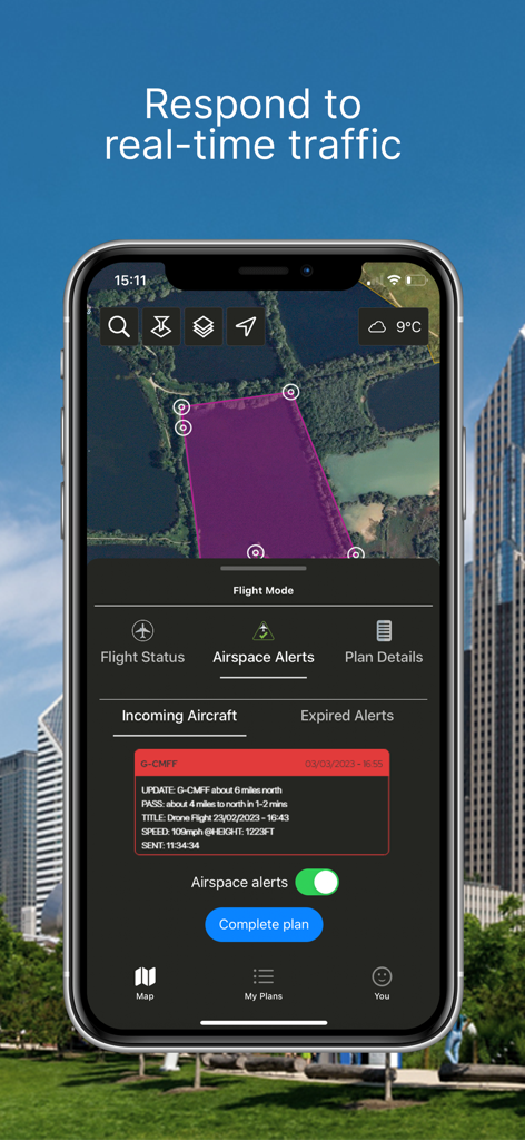
Benutzeroberfläche der Drone Assist App mit Echtzeit-Flugverkehrswarnungen und Fluggebietskarte
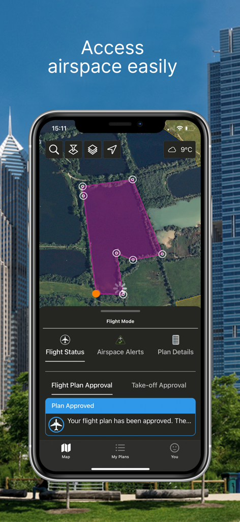
Ein Smartphone zeigt die Benutzeroberfläche der Drone Assist App mit einem violett schattierten Flugbereich auf einer Karte und einer Benachrichtigung, dass der Flugplan genehmigt wurde.
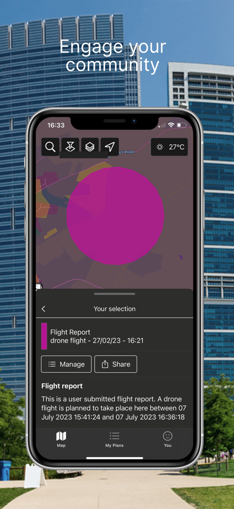
Mobile Drone Assist App mit Anzeige eines Flugberichts und Funktion zum Teilen von Karten
Beschreibung
Download
Ähnliche Apps
Top-gerankte Apps in derselben Kategorie

Google Maps
Google LLC

Waze Navigation & Live Traffic
waze

AMap Global
AutoNavi Information Technology Co. Ltd.

百度地图-路线规划,出行必备
Beijing Baidu Netcom Science & Technology Co.,Ltd

Moovit: Bus & Transit Tracker
Moovit App Global LTD

Transit • Subway & Bus Times
9280-0366 Quebec inc.

ParkMobile: Park. Pay. Go.
Parkmobile USA, Inc

腾讯地图-路线规划,导航地铁打车出行
Shenzhen Tencent Computer Systems Company Limited

Île-de-France Mobilités
Ile de France Mobilites
Diese Seite ist keine offizielle Seite der App oder ihres Entwicklers, sondern eine unabhängige redaktionelle Veröffentlichung, die zu Informations- und Kommentarzwecken erstellt wurde. Sofern nicht ausdrücklich anders angegeben, sind weder die App noch ihr Entwickler mit MWM, Apple, Google Play, dem App-Herausgeber oder dem Entwickler der App verbunden, von ihnen unterstützt, gesponsert, autorisiert oder anderweitig offiziell verbunden, und nichts auf dieser Seite impliziert, dass die App unter Verwendung der Dienste von MWM entwickelt wurde. Alle Marken, Logos, Screenshots und andere Inhalte bleiben Eigentum ihrer jeweiligen Inhaber.