Diese Seite ist keine offizielle Seite der App oder ihres Entwicklers, sondern eine unabhängige redaktionelle Veröffentlichung, die zu Informations- und Kommentarzwecken erstellt wurde. Sofern nicht ausdrücklich anders angegeben, sind weder die App noch ihr Entwickler mit MWM, Apple, Google Play, dem App-Herausgeber oder dem Entwickler der App verbunden, von ihnen unterstützt, gesponsert, autorisiert oder anderweitig offiziell verbunden, und nichts auf dieser Seite impliziert, dass die App unter Verwendung der Dienste von MWM entwickelt wurde. Alle Marken, Logos, Screenshots und andere Inhalte bleiben Eigentum ihrer jeweiligen Inhaber.
Flyskyhy
Verwandeln Sie Ihr Gerät in ein leistungsstarkes GPS-Vario mit Echtzeit-Windanalyse, anpassbaren Cockpit-Anzeigen und Live-Tracking. Fliegen Sie weiter, sicherer und intelligenter mit fortschrittlicher Thermen-Kartierung und Luftraumschutz.
Kennzahlen
Downloads
198K+
Bewertung
4.4/5
Bewertungen gesamt
600
Herausgeber
Rene Dekker
Kategorie
Sports
Sprachen
8
Neueste Version
9.4
Größe
22.6 MB
Erstveröffentlichung
17. Apr. 2012
Funktionen
Steigern Sie Ihre Flugintelligenz
Der Goldstandard für Gleitschirm- und Hängegleiterpiloten. Verwandeln Sie Ihr iPhone in ein hochpräzises digitales Cockpit, das auf Sicherheit, Leistung und Gemeinschaft ausgelegt ist.
Präzise Flugdaten
Zugriff auf Echtzeit-Höhenmesser, Bodengeschwindigkeit und Windstärke. Unsere intuitive Karte hilft Ihnen, Thermiken zu zentrieren und die Gleitleistung zu Landezonen zu überprüfen.
Luftraumsicherheit & Wegpunkte
Fliegen Sie mit Zuversicht mit Luftraumdaten aus 30 Ländern. Erhalten Sie visuelle und akustische Warnungen, um in der Nähe von Sperrzonen konform und sicher zu bleiben.
Die folgenden Screenshots und die Beschreibung stammen direkt aus dem offiziellen Store-Eintrag der App und sind Eigentum des Entwicklers.
App Store
Screenshots
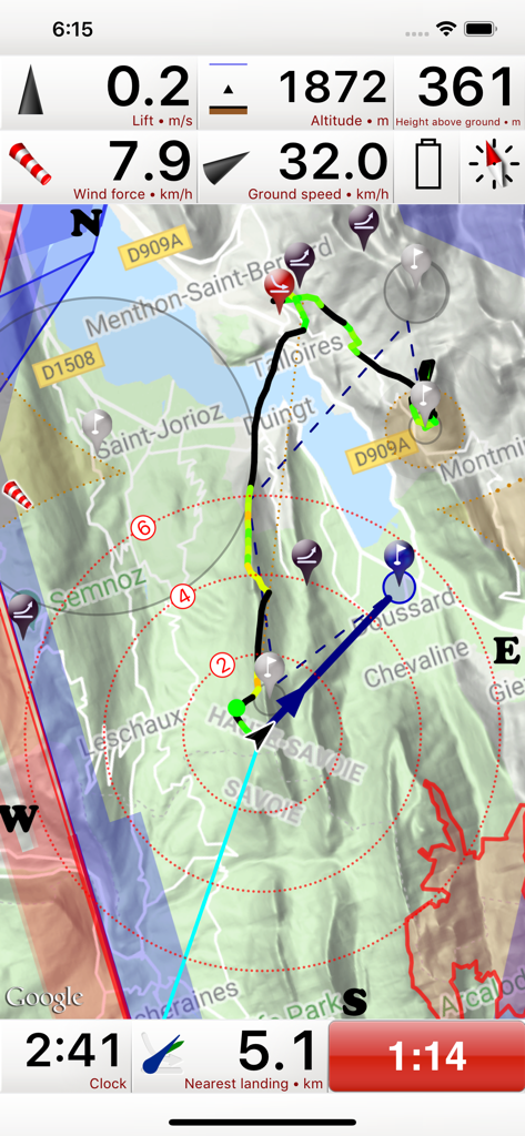
Flyskyhy App Fluginstrumenten-Oberfläche mit Höhenmesser, Bodengeschwindigkeit und bewegter Karte für Gleitschirmfliegen
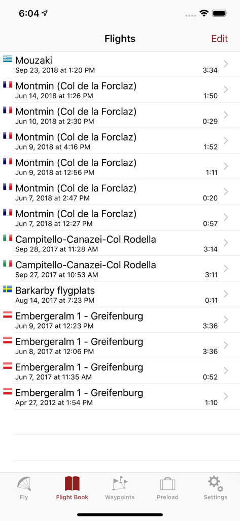
Eine Liste aufgezeichneter Gleitschirmflüge mit Ort, Datum und Dauer in der Flyskyhy App
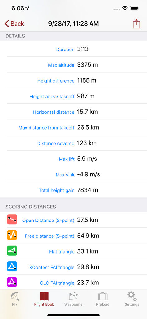
Detaillierte Flugprotokollstatistiken und Bewertung von Distanzen für Gleitschirmfliegen, angezeigt in der Flyskyhy App.
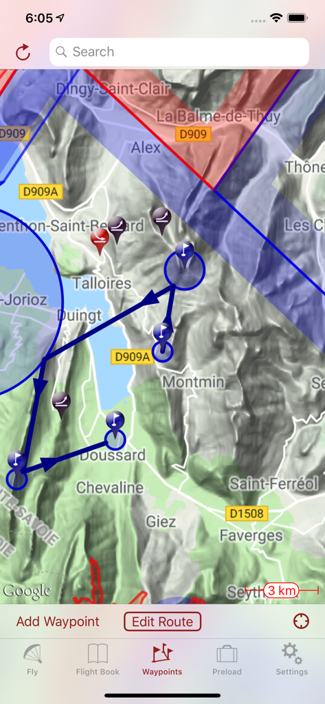
Topografische Karte in der Flyskyhy App, die eine geplante Flugroute mit Wegpunkten und Lufträumen anzeigt
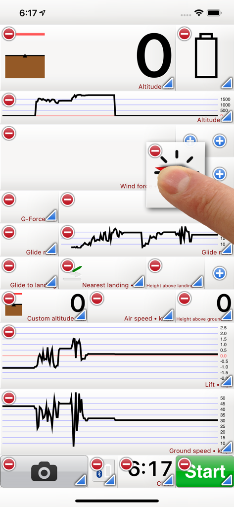
Flyskyhy App-Oberfläche mit anpassbaren Flugdaten-Widgets und Diagrammen für Piloten
Beschreibung
Flyskyhy forms your flight instrument during flight and shows all information you need for that. You get the normal data like altitude, climb rate, ground speed, and glide angle. But it also calculates and shows the current wind direction and strength, very important for your safety.
A moving and rotating map shows your current flying position and flight trail. It indicates where you have gone up (in a thermal), and where you have had faster than normal decline. With that, you can easily find back that thermal that you lost. The map also shows the nearest known landing spots, and whether they are reachable by normal glide, given your current altitude and wind direction.
Integration with Bluetooth varios SensBox, FlyNet, GoFly iPico, XC-Tracer, BlueFlyVario, or SkyDrop gives accurate altitude and lift information. That turns your iPhone into an full-fletched GPS-vario, including vario tones.
The app makes a full log of your flight, that can be analyzed afterwards. Besides normal data like start and landing positions, duration of flight, and an altitude graph of the flight, Flyskyhy also calculates the scoring distances for you. So you can immediately see whether you have broken that FAI triangle record.
Your live location is reported on livetrack24.com or loctome.com if you desire, so anybody can follow your flight while it is happening. If you are flying together with friends, then their location is shown on your map during your flight. So you never have to wonder anymore whether they are in front of or behind you.
The flight display has multiple screens which are all fully configurable. You can move all elements to other spots, delete and add elements, and resize them.
Through in-app purchases, the app also supports airspaces and waypoints.
The app is optimised for paragliding and hang gliders, but can be used with all kinds of airsports.
Main features during the flight;
• Altitude, climb rate, ground speed, air speed, direction, glide angle and many more
• Wind strength and direction
• Moving map of the flying area
• Spots where you have had lift, great for thermal coring
• Shows whether you can still reach a landing spot with the current altitude and wind
• Live tracking of your flight on livetrack24.com or loctome.com
• Shows live location of your friends during flight
After the flight:
• Full logbook of all your flights
• Basic flight data like start/landing, duration, height difference, distance flown, and many more
• Calculation of 5-points, open triangle, and FAI triangle distances
• Graph of altitude and climb rate
• Signed IGC and KML log files of flights
• Transfer the log to iTunes or send by email
• Upload the flight directly to XContest, ParaglidingForum, DHV-XC, and other Leonardo servers
• Open flight in Google Earth on the iPhone
• Replay the flight and relive it!
By purchasing the Waypoints Extension you get access to:
• A fully zoomable and scrollable map with the waypoints and optimised route. The map also shows start and landing spots, as well as restricted airspaces (with the Airspace Extension)
• Enter new waypoints, either on the map or by specifying the parameters
• Full route support with start time, goal, entry/exit points, etc.
• Many instruments to guide you along the route
• Visible and audible indication when a waypoint has been reached
• Complete waypoints organiser
• Import and export of various waypoint file formats
By purchasing the Airspace Extension you get access to:
• Airspaces of 30 countries
• Display of airspaces on the map with configurable colors and formats
• Display of your vertical position w.r.t. airspaces
• Visible and audible warnings when approaching and entering an airspace
• Shows local airspaces by touching a spot on the map
Note: a live internet connection is required for live tracking of your and your friends locations
Note: continuous GPS and screen usage makes the battery drain faster than normal
Diese Seite ist keine offizielle Seite der App oder ihres Entwicklers, sondern eine unabhängige redaktionelle Veröffentlichung, die zu Informations- und Kommentarzwecken erstellt wurde. Sofern nicht ausdrücklich anders angegeben, sind weder die App noch ihr Entwickler mit MWM, Apple, Google Play, dem App-Herausgeber oder dem Entwickler der App verbunden, von ihnen unterstützt, gesponsert, autorisiert oder anderweitig offiziell verbunden, und nichts auf dieser Seite impliziert, dass die App unter Verwendung der Dienste von MWM entwickelt wurde. Alle Marken, Logos, Screenshots und andere Inhalte bleiben Eigentum ihrer jeweiligen Inhaber.