Diese Seite ist keine offizielle Seite der App oder ihres Entwicklers, sondern eine unabhängige redaktionelle Veröffentlichung, die zu Informations- und Kommentarzwecken erstellt wurde. Sofern nicht ausdrücklich anders angegeben, sind weder die App noch ihr Entwickler mit MWM, Apple, Google Play, dem App-Herausgeber oder dem Entwickler der App verbunden, von ihnen unterstützt, gesponsert, autorisiert oder anderweitig offiziell verbunden, und nichts auf dieser Seite impliziert, dass die App unter Verwendung der Dienste von MWM entwickelt wurde. Alle Marken, Logos, Screenshots und andere Inhalte bleiben Eigentum ihrer jeweiligen Inhaber.

Fulcrum GIS field data capture
Optimieren Sie Inspektionen, Anlagenverfolgung und Erhebungen mit KI-gestützten mobilen Apps. Erfassen Sie präzise Geodaten überall – auch offline – und synchronisieren Sie nahtlos mit Esri ArcGIS.
Downloads
41K+Bewertung
Bewertungen gesamt
100Herausgeber
Kategorie
BusinessSprachen
30Neueste Version
2601.2.0Größe
162.7 MBErstveröffentlichung
7. Okt. 2011Präzise Felddaten, vereinfacht
Rüsten Sie Ihre Crew mit einer robusten mobilen Lösung für digitale Inspektionen, Echtzeit-Anlagenverfolgung und professionelle GIS-Kartierung aus.
Zuverlässige Offline-Datenerfassung
Lassen Sie niemals einen Funkloch Ihren Fortschritt stoppen. Erfassen Sie GPS-getaggte Daten an abgelegenen Orten und synchronisieren Sie sie automatisch, sobald Sie wieder Empfang haben.
Freihändige KI-Spracheingabe
Lösen Sie das Problem der 'schmutzigen Hände' mit Audio FastFill. Diktieren Sie Standortnotizen und Beobachtungen sofort, während Sie sich auf die Arbeit konzentrieren.
Die folgenden Screenshots und die Beschreibung stammen direkt aus dem offiziellen Store-Eintrag der App und sind Eigentum des Entwicklers.
App Store
Screenshots
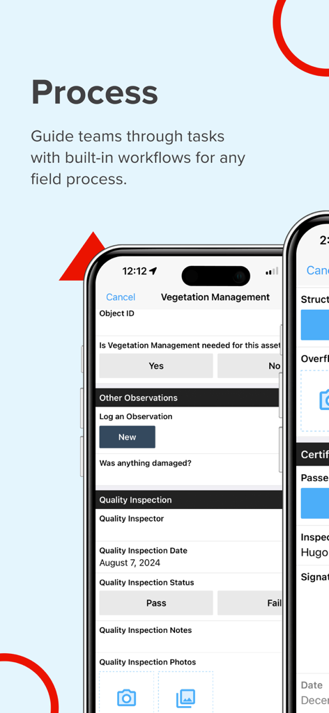
Fulcrum mobile app interface for managing field workflows and vegetation inspections
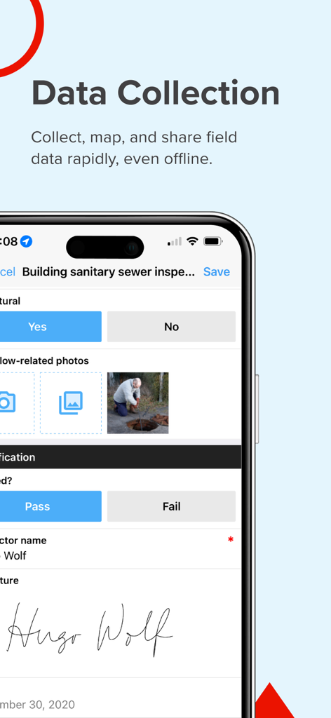
Eine mobile Oberfläche der Fulcrum App, die ein Inspektionsformular für sanitäre Kanäle mit einem Foto des Arbeiters und einer digitalen Unterschrift zeigt.
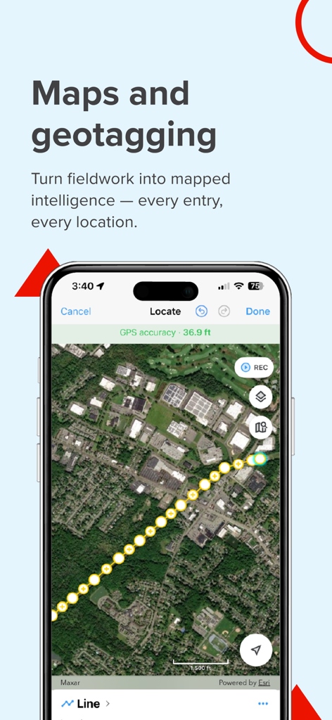
Fulcrum App-Bildschirm, der GIS-Kartierung und Geotagging-Datenerfassung im Feld auf einer Satellitenansicht demonstriert.
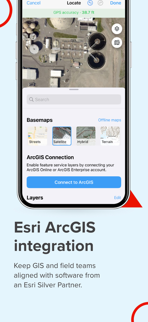
Fulcrum mobile App, die Esri ArcGIS-Integration und Satellitenkartenoptionen für Fachleute im Außendienst anzeigt
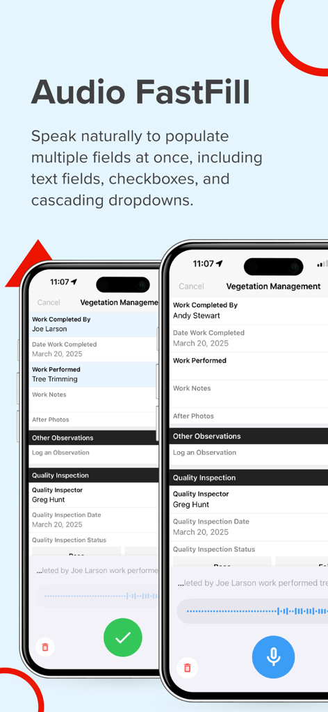
Screenshot der Fulcrum App, die Audio FastFill für KI-gestützte Spracheingabe in Feldinspektionsformularen zeigt.
Beschreibung
Download
Ähnliche Apps
Top-gerankte Apps in derselben Kategorie

Microsoft Teams
Microsoft Corporation

Zoom Workplace
Zoom Communications, Inc.

WhatsApp Business
WhatsApp Inc.

Indeed Job Search
Indeed Inc.

LinkedIn: Network & Job Finder
LinkedIn Corporation

Adobe Acrobat Reader: Sign PDF
Adobe Inc.

WeCom-Work Communication&Tools
Tencent Technology (Shenzhen) Company Limited

BOSS直聘-招聘求职找工作神器
Beijing China Product Bo Farce Network Technology Co., Ltd.

DingDing - Redefine Work in AI
DingTalk Technology Co., Ltd.
Diese Seite ist keine offizielle Seite der App oder ihres Entwicklers, sondern eine unabhängige redaktionelle Veröffentlichung, die zu Informations- und Kommentarzwecken erstellt wurde. Sofern nicht ausdrücklich anders angegeben, sind weder die App noch ihr Entwickler mit MWM, Apple, Google Play, dem App-Herausgeber oder dem Entwickler der App verbunden, von ihnen unterstützt, gesponsert, autorisiert oder anderweitig offiziell verbunden, und nichts auf dieser Seite impliziert, dass die App unter Verwendung der Dienste von MWM entwickelt wurde. Alle Marken, Logos, Screenshots und andere Inhalte bleiben Eigentum ihrer jeweiligen Inhaber.