Diese Seite ist keine offizielle Seite der App oder ihres Entwicklers, sondern eine unabhängige redaktionelle Veröffentlichung, die zu Informations- und Kommentarzwecken erstellt wurde. Sofern nicht ausdrücklich anders angegeben, sind weder die App noch ihr Entwickler mit MWM, Apple, Google Play, dem App-Herausgeber oder dem Entwickler der App verbunden, von ihnen unterstützt, gesponsert, autorisiert oder anderweitig offiziell verbunden, und nichts auf dieser Seite impliziert, dass die App unter Verwendung der Dienste von MWM entwickelt wurde. Alle Marken, Logos, Screenshots und andere Inhalte bleiben Eigentum ihrer jeweiligen Inhaber.

Geo Timestamp : GPS Map Camera
Das ultimative Dokumentationswerkzeug für Inspektionen vor Ort, Immobilien und professionelle Berichterstattung. Betten Sie automatisch präzise GPS-Koordinaten, Kartenüberlagerungen und Zeitstempel ein, um sofort überprüfbare Aufzeichnungen zu erstellen – auch an Orten ohne Internetverbindung.
Downloads
8K+Bewertung
Bewertungen gesamt
0Herausgeber
Kategorie
NavigationSprachen
1Neueste Version
1.6Größe
47.2 MBErstveröffentlichung
1. Sept. 2025Präzise Dokumentation bei jedem Klick
Verwandeln Sie Ihre Fotos mit automatischem GPS, Kartenüberlagerungen und Zeitstempeldaten in überprüfbare Aufzeichnungen, die für Fachleute und Abenteurer gleichermaßen konzipiert sind.
Automatisierte professionelle Stempelung
Betten Sie sofort GPS-Koordinaten, genaue Adressen und zeitgenaue Stempel ein, um unbestreitbare Arbeitsnachweise für Inspektionen oder Reiseberichte zu liefern.
Integrierte Kartenüberlagerungen
Visualisieren Sie Ihren genauen Standort mit Satelliten- oder Standardkartenansichten, die direkt auf Ihr Bild gebrannt sind, und bieten Sie so sofortigen geografischen Kontext für jede Aufnahme.
Häufig gestellte Fragen
Alles, was Sie über wissen müssen Geo Timestamp : GPS Map Camera
Was ist Geo Timestamp: GPS Map Camera?
Geo Timestamp: GPS Map Camera ist eine Kamera-App, die automatisch GPS-Koordinaten, Kartenansicht sowie Datums- und Zeitstempel direkt auf Fotos hinzufügt. Sie erfasst, wo und wann jedes Foto aufgenommen wurde.
Fügt Geo Timestamp: GPS Map Camera automatisch GPS-Standorte zu Fotos hinzu?
Ja, Geo Timestamp: GPS Map Camera fügt automatisch aktuelle GPS-Koordinaten und Adressdetails zu jedem aufgenommenen Foto hinzu. Es unterstützt auch die automatische GPS-Erkennung.
Kann Geo Timestamp: GPS Map Camera Datums- und Zeitstempel zu Fotos hinzufügen?
Ja, die App fügt automatisch das genaue Datum und die Uhrzeit zu jedem Foto hinzu, um Aufzeichnungen zu führen und die Überprüfung zu ermöglichen. Dies ist ein Kernmerkmal der Geo Timestamp-App.
Bietet Geo Timestamp: GPS Map Camera Karten-Overlays auf Fotos?
Ja, Geo Timestamp: GPS Map Camera zeigt den Fotostandort direkt auf einer Karte mit Satelliten-, Hybrid- oder Standard-Kartenstilen als Overlay auf Ihren Bildern an.
Kann Geo Timestamp: GPS Map Camera ohne Internet- oder GPS-Signal verwendet werden?
Ja, Geo Timestamp: GPS Map Camera unterstützt einen Offline-Modus. Benutzer können Fotos aufnehmen und speichern, auch wenn das Internet- oder GPS-Signal schwach ist.
Ist es möglich, den Standort in Geo Timestamp: GPS Map Camera manuell anzupassen?
Ja, die Geo Timestamp-App bietet eine manuelle Standortoption. Benutzer können einen bestimmten Kartenpunkt anpassen oder auswählen, wenn die automatische GPS-Erkennung nicht verfügbar ist.
Wie kann ich Fotos von Geo Timestamp: GPS Map Camera teilen?
Geo Timestamp: GPS Map Camera ermöglicht einfaches Teilen. Benutzer können ihre Geo-Tagged und zeitgestempelten Fotos sofort per E-Mail, Chat oder über soziale Medien teilen.
Wer profitiert von der Verwendung von Geo Timestamp: GPS Map Camera?
Die Geo Timestamp: GPS Map Camera-App ist ideal für Reisende, Ingenieure, Vermesser, Immobilienprofis und Außendienstmitarbeiter, die eine Fototimestamping mit Kartenstandort und überprüfbaren Daten benötigen.
Bietet Geo Timestamp: GPS Map Camera vordefinierte Vorlagen für Standortinformationen?
Ja, die App bietet professionelle Vorlagenstile für Reiseberichte, Arbeitsberichte und Feldinspektionen. Sie enthält Optionen wie Navigationskompass und klassische Vorlagen.
Welche Informationen bettet Geo Timestamp: GPS Map Camera in Fotos ein?
Die Geo Timestamp: GPS Map Camera-App stempelt Fotos automatisch mit Längen- und Breitengrad, Adresse und Kartenansicht, Datum und Uhrzeit, Kompassrichtung und Höhe (falls aktiviert).
Die folgenden Screenshots und die Beschreibung stammen direkt aus dem offiziellen Store-Eintrag der App und sind Eigentum des Entwicklers.
App Store
Screenshots
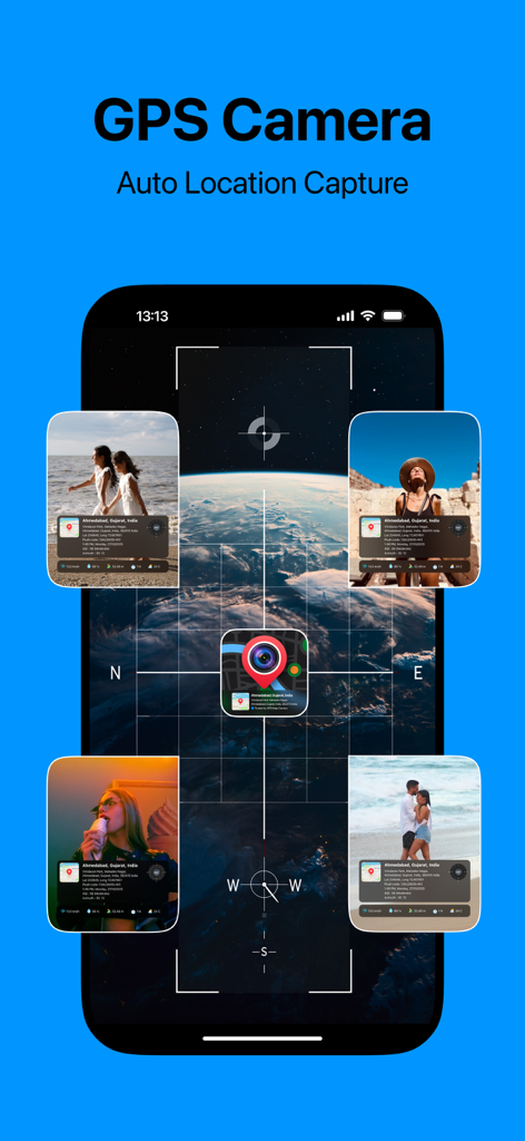
Oberfläche der GPS Map Camera App, die die automatische Standortaufnahme und Fotostempel mit Kartenüberlagerungen anzeigt
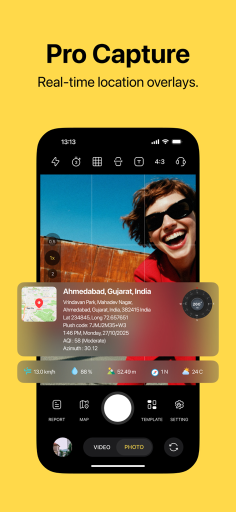
Mobile App-Oberfläche, die ein Foto mit Echtzeit-GPS-Standortdaten und Kartenüberlagerung zeigt
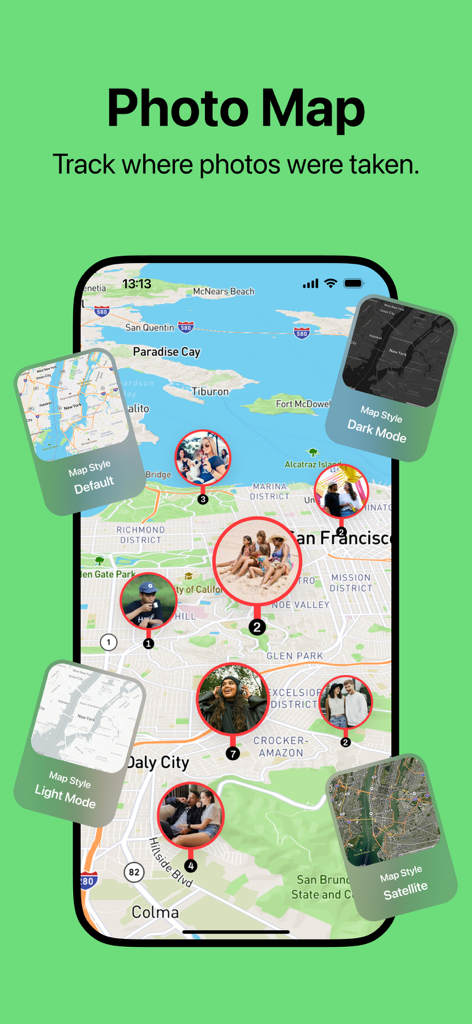
Foto-Kartenfunktion, die Fotostandorte auf einer Karte mit verschiedenen Kartenstiloptionen anzeigt
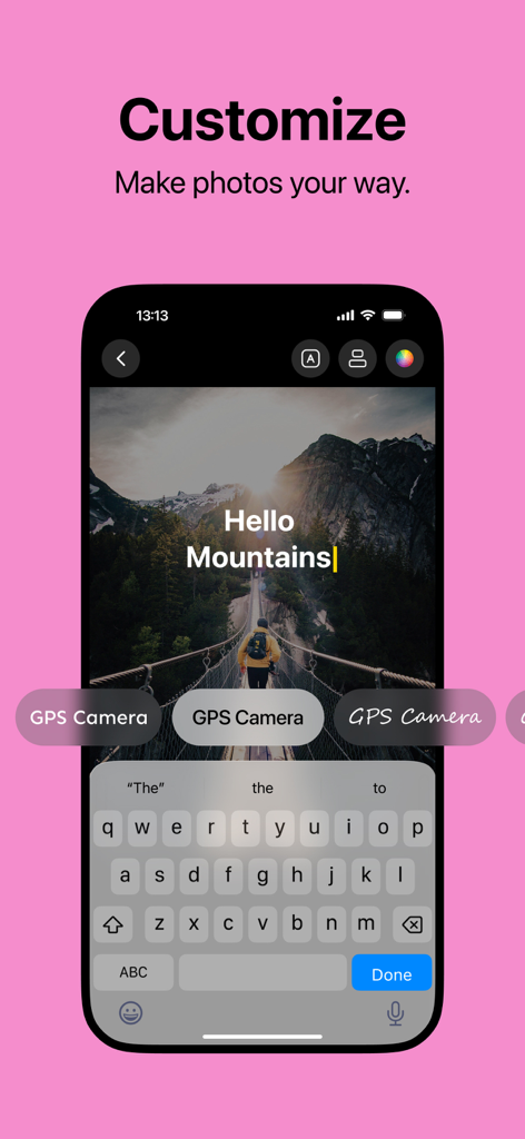
Smartphone-Oberfläche, die Schriftart- und Textanpassungsoptionen auf einem GPS-getaggten Foto von Bergen zeigt
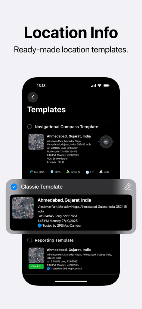
Mobile App-Oberfläche, die vorgefertigte Standortinformationsvorlagen für die GPS-Fotostempelung anzeigt
Beschreibung
Download
Ähnliche Apps
Top-gerankte Apps in derselben Kategorie

Google Maps
Google LLC

Waze Navigation & Live Traffic
waze

AMap Global
AutoNavi Information Technology Co. Ltd.

百度地图-路线规划,出行必备
Beijing Baidu Netcom Science & Technology Co.,Ltd

Moovit: Bus & Transit Tracker
Moovit App Global LTD

Transit • Subway & Bus Times
9280-0366 Quebec inc.

ParkMobile: Park. Pay. Go.
Parkmobile USA, Inc

腾讯地图-路线规划,导航地铁打车出行
Shenzhen Tencent Computer Systems Company Limited

Île-de-France Mobilités
Ile de France Mobilites
Diese Seite ist keine offizielle Seite der App oder ihres Entwicklers, sondern eine unabhängige redaktionelle Veröffentlichung, die zu Informations- und Kommentarzwecken erstellt wurde. Sofern nicht ausdrücklich anders angegeben, sind weder die App noch ihr Entwickler mit MWM, Apple, Google Play, dem App-Herausgeber oder dem Entwickler der App verbunden, von ihnen unterstützt, gesponsert, autorisiert oder anderweitig offiziell verbunden, und nichts auf dieser Seite impliziert, dass die App unter Verwendung der Dienste von MWM entwickelt wurde. Alle Marken, Logos, Screenshots und andere Inhalte bleiben Eigentum ihrer jeweiligen Inhaber.