Diese Seite ist keine offizielle Seite der App oder ihres Entwicklers, sondern eine unabhängige redaktionelle Veröffentlichung, die zu Informations- und Kommentarzwecken erstellt wurde. Sofern nicht ausdrücklich anders angegeben, sind weder die App noch ihr Entwickler mit MWM, Apple, Google Play, dem App-Herausgeber oder dem Entwickler der App verbunden, von ihnen unterstützt, gesponsert, autorisiert oder anderweitig offiziell verbunden, und nichts auf dieser Seite impliziert, dass die App unter Verwendung der Dienste von MWM entwickelt wurde. Alle Marken, Logos, Screenshots und andere Inhalte bleiben Eigentum ihrer jeweiligen Inhaber.

GPS Land Measurement & Survey
Das unverzichtbare Werkzeug für Bauunternehmer, Landwirte und Grundstückseigentümer. Messen Sie Flächen, kartieren Sie Grundstücksgrenzen und berechnen Sie Entfernungen mit GPS-Genauigkeit – auch offline und an abgelegensten Orten.
Downloads
561K+Bewertung
Bewertungen gesamt
6K+Herausgeber
Kategorie
UtilitiesSprachen
1Neueste Version
10.3.3Größe
58.3 MBErstveröffentlichung
25. Jan. 2013Professionelle Feldwerkzeuge für jeden Hektar
Verwandeln Sie Ihr Mobilgerät in eine hochpräzise Vermessungssoftware. Mapulator liefert die Genauigkeit und Datenintegrität, die Bauunternehmer, Landwirte und Grundstückseigentümer benötigen, um Grundstücke souverän zu verwalten.
Präzisionsflächen- & Umfangsvermessung
Berechnen Sie exakte Quadratfuß- oder Hektarflächen für jedes Gelände. Wechseln Sie sofort zwischen metrischen und imperialen Einheiten, um Ihren professionellen Standards und Projektanforderungen zu entsprechen.
Live-GPS-Tracking & Offline-Unterstützung
Gehen Sie Ihre Grundstücksgrenzen ab, um Grenzen in Echtzeit zu messen. Zuverlässige Offline-Karten stellen sicher, dass Sie bei der Arbeit in abgelegenen ländlichen Gebieten oder auf neuen Baustellen keinen Fortschritt verlieren.
Die folgenden Screenshots und die Beschreibung stammen direkt aus dem offiziellen Store-Eintrag der App und sind Eigentum des Entwicklers.
App Store
Screenshots
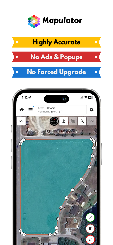
Mapulator App-Oberfläche, die eine Landfläche von fünf Hektar auf einer Satellitenkarte misst
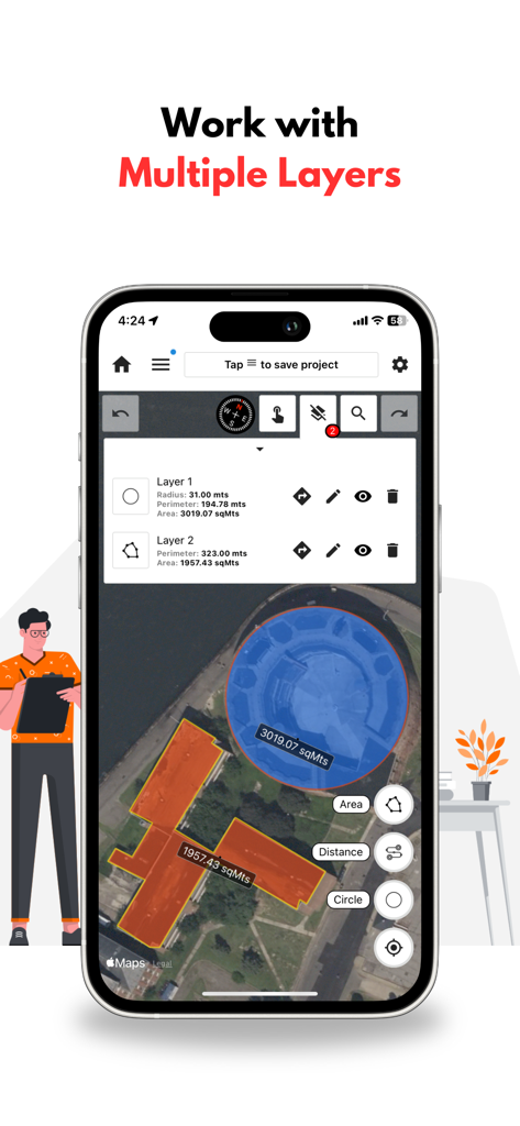
GPS-Landvermessungs-App-Oberfläche, die mehrere Ebenen für eine kreisförmige und eine polygonale Flächenmessung auf einer Karte zeigt.
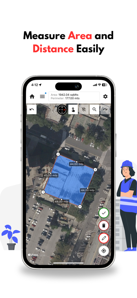
Mapulator App-Oberfläche, die Flächen- und Umfangsvermessung auf einer Satellitenkarte anzeigt
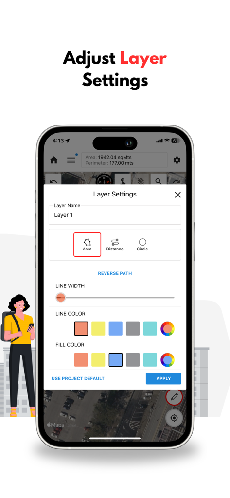
Smartphone-Bildschirm, der das Ebenen-Einstellungen-Menü der Mapulator-App zur Anpassung von Kartenfarben und -stilen zeigt
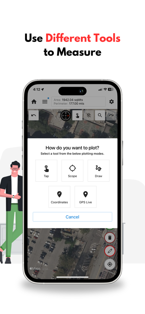
Oberfläche der Mapulator-App, die verschiedene Zeichenwerkzeuge wie Tippen, Bereich, Zeichnen und GPS Live über einer Satellitenkarte zur Landvermessung zeigt.
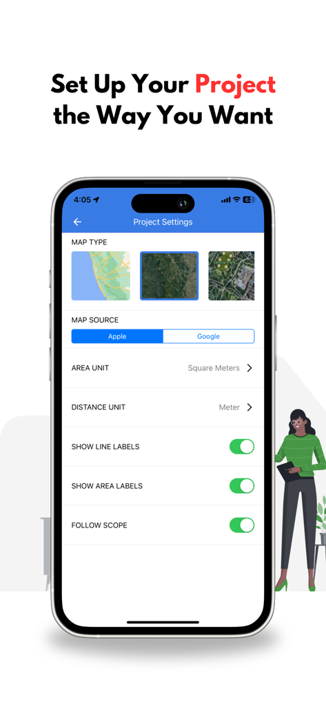
Oberfläche mit Projekteinstellungen in der Mapulator-App mit Optionen für Kartentypen und Maßeinheiten
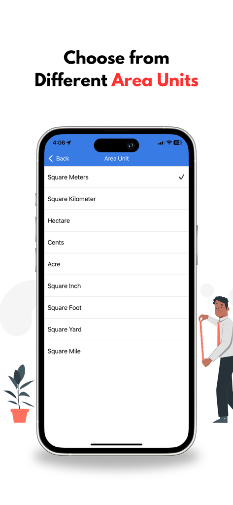
Ein Smartphone-Bildschirm, der eine Liste verschiedener Flächenmaßeinheiten wie Hektar, Ar und Quadratfuß in der Mapulator-App anzeigt
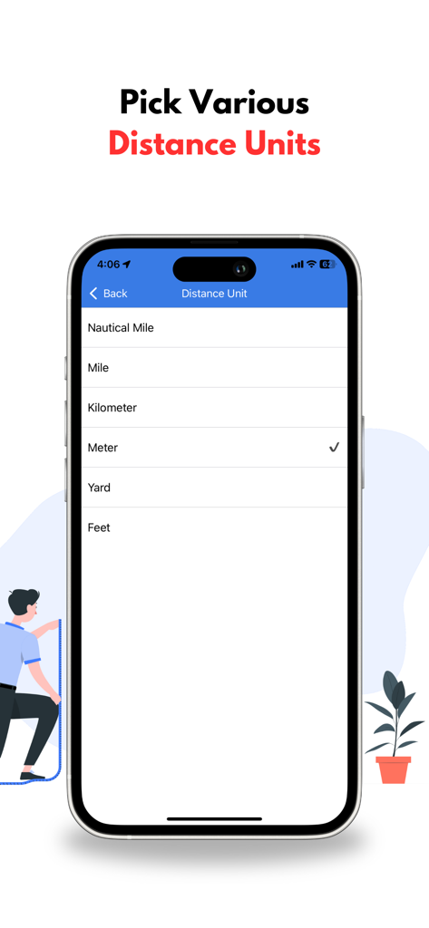
Oberfläche, die eine Auswahl von Längeneinheiten einschließlich Meilen, Kilometern und Metern anzeigt
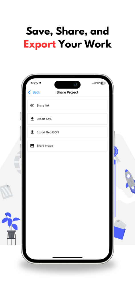
Mapulator App-Bildschirm mit Projektfreigabe- und Exportoptionen für KML- und GeoJSON-Dateien
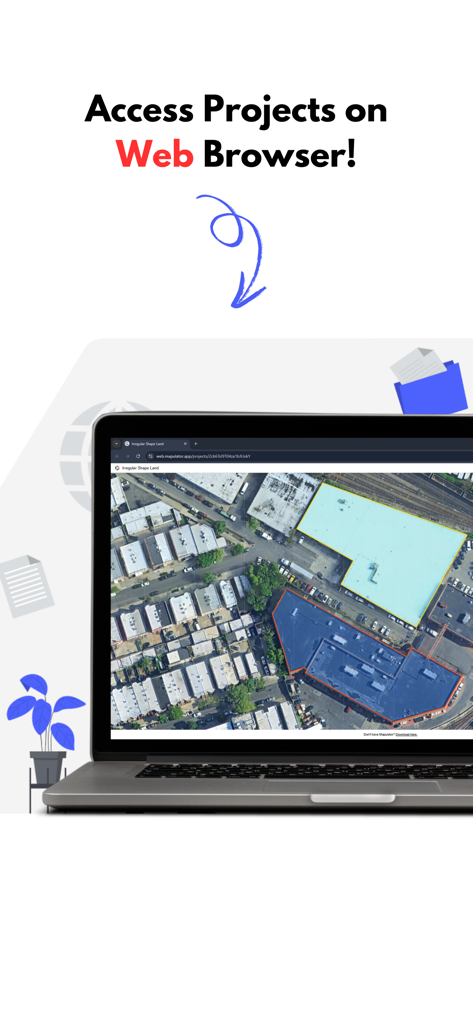
Ein Laptop-Bildschirm, der die Mapulator-Weboberfläche mit farbkodierten Landvermessungen auf einer Satellitenkarte anzeigt.
Beschreibung
Download
Ähnliche Apps
Top-gerankte Apps in derselben Kategorie

Google LLC

Google Chrome
Google LLC

中国移动(手机营业厅)
China Mobile Online Services Co., Ltd.

Google Authenticator
Google LLC

CNH do Brasil
Servicos e Informacoes do Brasil

Cleanup: Phone Storage Cleaner
DEEP FLOW SOFTWARE SERVICES - FZCO

gov.br
Servicos e Informacoes do Brasil

中国电信-全国统一官方服务平台
CHINA TELECOM Corporation Ltd.

Microsoft Edge: AI Browser
Microsoft Corporation
Diese Seite ist keine offizielle Seite der App oder ihres Entwicklers, sondern eine unabhängige redaktionelle Veröffentlichung, die zu Informations- und Kommentarzwecken erstellt wurde. Sofern nicht ausdrücklich anders angegeben, sind weder die App noch ihr Entwickler mit MWM, Apple, Google Play, dem App-Herausgeber oder dem Entwickler der App verbunden, von ihnen unterstützt, gesponsert, autorisiert oder anderweitig offiziell verbunden, und nichts auf dieser Seite impliziert, dass die App unter Verwendung der Dienste von MWM entwickelt wurde. Alle Marken, Logos, Screenshots und andere Inhalte bleiben Eigentum ihrer jeweiligen Inhaber.