Diese Seite ist keine offizielle Seite der App oder ihres Entwicklers, sondern eine unabhängige redaktionelle Veröffentlichung, die zu Informations- und Kommentarzwecken erstellt wurde. Sofern nicht ausdrücklich anders angegeben, sind weder die App noch ihr Entwickler mit MWM, Apple, Google Play, dem App-Herausgeber oder dem Entwickler der App verbunden, von ihnen unterstützt, gesponsert, autorisiert oder anderweitig offiziell verbunden, und nichts auf dieser Seite impliziert, dass die App unter Verwendung der Dienste von MWM entwickelt wurde. Alle Marken, Logos, Screenshots und andere Inhalte bleiben Eigentum ihrer jeweiligen Inhaber.

Hunting Points: GPS & Hunt App
Navigieren Sie mit Zuversicht im Hinterland mit Offline-Karten, identifizieren Sie Landgrenzen sofort und meistern Sie Ihre Jagd mit Echtzeit-Wind- und Hirschaktivitätsvorhersagen.
Downloads
371K+Bewertung
Bewertungen gesamt
5K+Herausgeber
Kategorie
NavigationSprachen
1Neueste Version
1.8.9Größe
148.1 MBErstveröffentlichung
31. Aug. 2018Der ultimative taktische Vorteil für jeden Jäger
Von detaillierten Grundstücksgrenzen bis hin zu Echtzeit-Windmustern – erhalten Sie die hochpräzisen Werkzeuge, die Sie zum Scouten, Navigieren und Erfolgreichsein in der Wildnis benötigen.
Beherrschen Sie die Grundstücksgrenzen
Identifizieren Sie sofort öffentliche und private Grundstücksgrenzen mit Namen von Landbesitzern und Flurstücksdaten, um mit Zuversicht zu jagen und legal zu bleiben.
Navigation abseits des Netzes
Verlieren Sie das Signal, aber nicht den Weg. Greifen Sie auf Offline-3D-Geländekarten und GPS-Tracking zu, um sicher zurück zum Basislager im tiefsten Hinterland zu navigieren.
Die folgenden Screenshots und die Beschreibung stammen direkt aus dem offiziellen Store-Eintrag der App und sind Eigentum des Entwicklers.
App Store
Screenshots
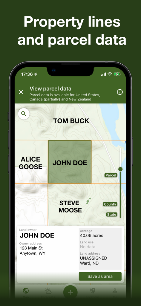
Smartphone-Bildschirm mit Grundstücksgrenzen und Landbesitzer-Flurstücksdaten auf einer Jagdkarte
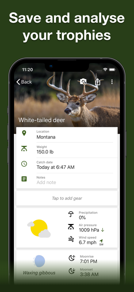
Hunting Points App Trophäenraum-Bildschirm mit einem Weißwedelhirsch-Fangbericht mit Wetter- und Solunar-Daten
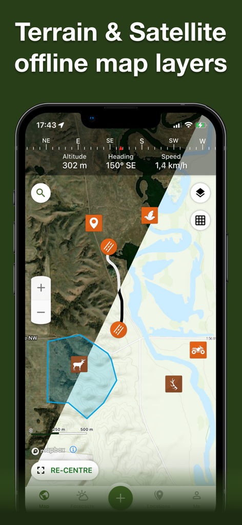
Hunting Points App zeigt eine geteilte Ansicht von Gelände- und Satelliten-Offline-Kartenebenen mit Jagdsymbolen und GPS-Daten
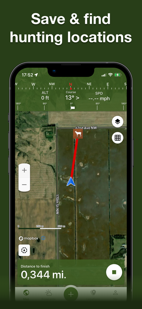
Screenshot der Hunting Points App zeigt eine Satellitenkarte mit einem Navigationspfad zu einem Hirsch-Wegpunkt
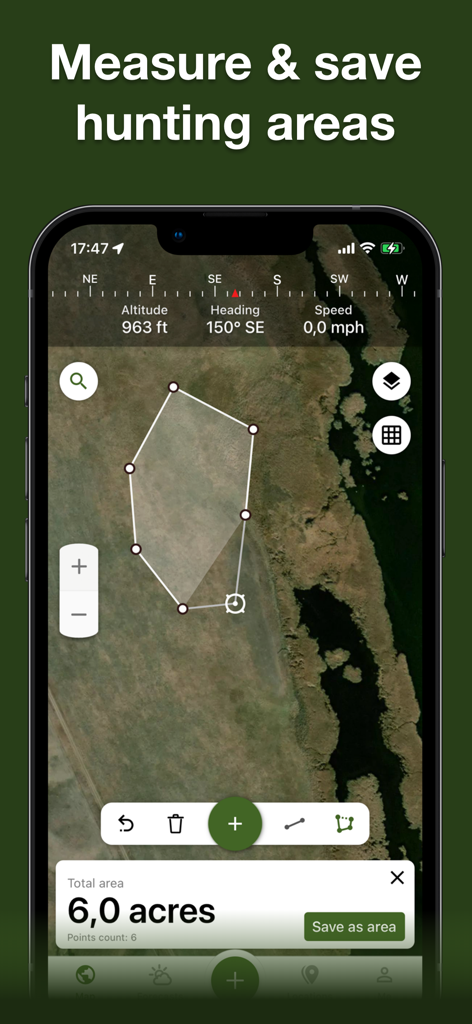
Eine Smartphone-Oberfläche zeigt eine Satellitenkarte mit einem gezeichneten Polygon zur Messung eines sechs Hektar großen Jagdgebiets.
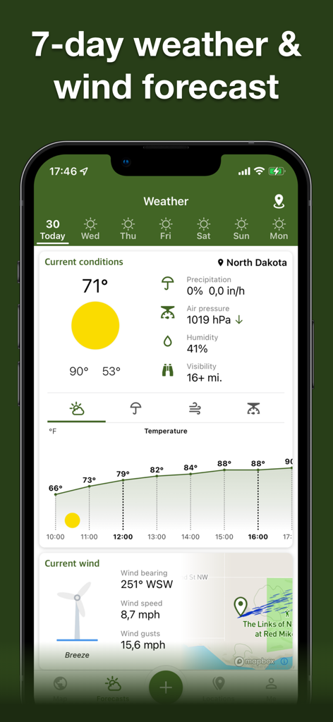
Wetter- und Windvorhersage-Bildschirm in der Hunting Points App
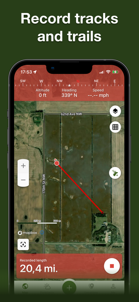
GPS-Track- und Trail-Aufnahme auf einer Satellitenkarte in der Hunting Points App
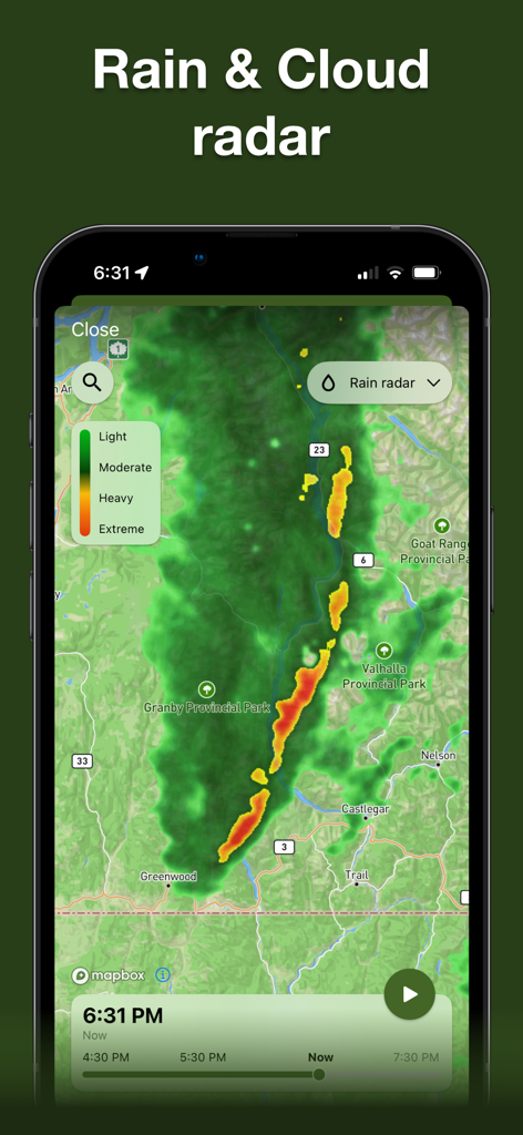
Regen- und Wolkenradar-Karte, die die Niederschlagsintensität für die Jagdplanung zeigt.
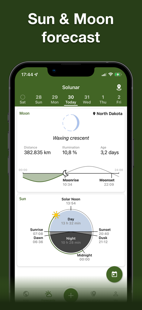
Detaillierte Solunar-Daten und Sonnen- und Mondvorhersage in der Hunting Points App
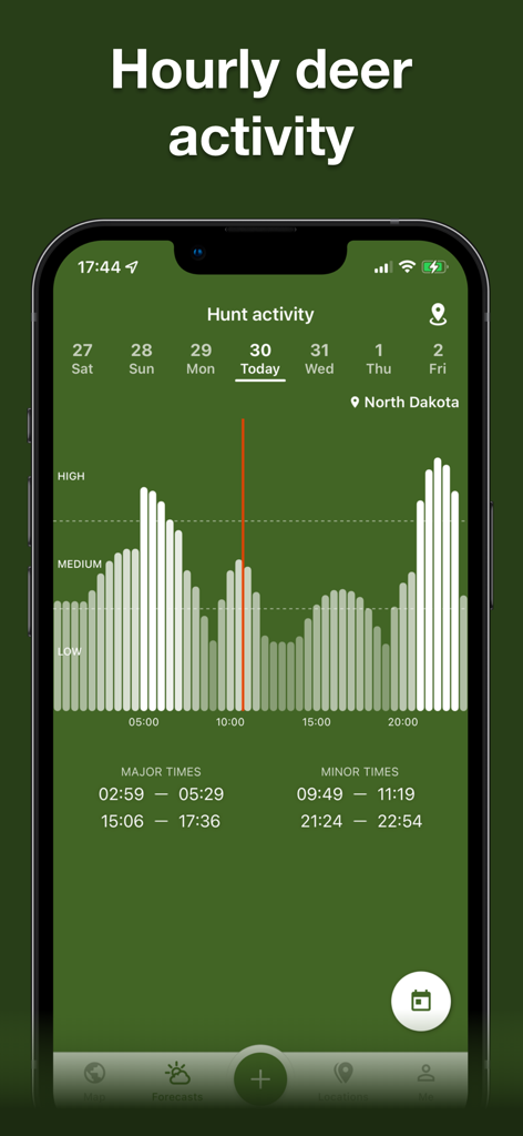
Ein mobiler App-Bildschirm zeigt eine Grafik der stündlichen Hirschaktivitätsniveaus und Fütterungszeiten für die Jagd in North Dakota.
Beschreibung
Download
Ähnliche Apps
Apps mit ähnlichen Funktionen und Nutzererfahrung

onX Hunt: GPS Hunting Maps
onXmaps, Inc.

GOHUNT: Research & Maps
GOHUNT, LLC

HuntWise: A Better Hunting App
Sportsman Tracker, Inc

HuntStand: GPS Maps & Tools
Good Sportsman Marketing, LLC

MyHunt: US Best Hunting App
Hunter & Companion Gesellschaft mit beschrankter Haftung

WeHunt
Natlink AB

DeerCast-Prep. Predict. Pursue
Good Sportsman Marketing, LLC

BaseMap: Hunting GPS Maps
BaseMap Inc

iHunter
Inside Outside Studios Inc.
Diese Seite ist keine offizielle Seite der App oder ihres Entwicklers, sondern eine unabhängige redaktionelle Veröffentlichung, die zu Informations- und Kommentarzwecken erstellt wurde. Sofern nicht ausdrücklich anders angegeben, sind weder die App noch ihr Entwickler mit MWM, Apple, Google Play, dem App-Herausgeber oder dem Entwickler der App verbunden, von ihnen unterstützt, gesponsert, autorisiert oder anderweitig offiziell verbunden, und nichts auf dieser Seite impliziert, dass die App unter Verwendung der Dienste von MWM entwickelt wurde. Alle Marken, Logos, Screenshots und andere Inhalte bleiben Eigentum ihrer jeweiligen Inhaber.