Diese Seite ist keine offizielle Seite der App oder ihres Entwicklers, sondern eine unabhängige redaktionelle Veröffentlichung, die zu Informations- und Kommentarzwecken erstellt wurde. Sofern nicht ausdrücklich anders angegeben, sind weder die App noch ihr Entwickler mit MWM, Apple, Google Play, dem App-Herausgeber oder dem Entwickler der App verbunden, von ihnen unterstützt, gesponsert, autorisiert oder anderweitig offiziell verbunden, und nichts auf dieser Seite impliziert, dass die App unter Verwendung der Dienste von MWM entwickelt wurde. Alle Marken, Logos, Screenshots und andere Inhalte bleiben Eigentum ihrer jeweiligen Inhaber.

Live Earth Map & GPS Map
Das All-in-One-Toolkit für hochauflösende Satellitenansichten, professionelle Flächenvermessung und stressfreie Navigation.
Downloads
10K+Bewertung
Bewertungen gesamt
200Herausgeber
Kategorie
NavigationSprachen
1Neueste Version
1.7.0Größe
80.3 MBErstveröffentlichung
20. Juli 2024Navigieren und messen Sie Ihre Welt mit absoluter Präzision
Ein All-in-One-Toolkit für Hausbesitzer, Bauunternehmer und Entdecker, um jeden Standort zu visualisieren und Entfernungen mit Leichtigkeit zu berechnen.
Professionelle Flächenvermessung
Berechnen Sie sofort Landflächen, Feldabmessungen oder Grundstücksgrenzen mit hochpräzisen GPS-Werkzeugen, die für Heimwerker und Immobilienprofis entwickelt wurden.
Live-Satelliten- und Straßen-Erkundung
Gewinnen Sie visuelle Sicherheit mit hochauflösenden Erdansichten. Begehen Sie Ihre Route vorab oder erkunden Sie weltberühmte Ziele von Ihrer Handfläche aus.
Die folgenden Screenshots und die Beschreibung stammen direkt aus dem offiziellen Store-Eintrag der App und sind Eigentum des Entwicklers.
App Store
Screenshots
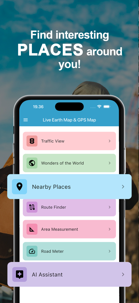
Hauptmenü der Live Earth Map und GPS Map App, das Navigations- und Flächenmessfunktionen anzeigt

Ein Smartphone-Bildschirm, der einen KI-Assistenten zeigt, der Filmtheaterempfehlungen in einer Reise-App gibt
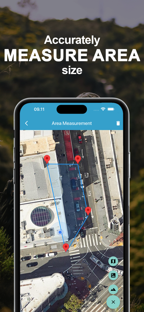
Satellitenkarten-Oberfläche, die die Flächenvermessung mit Pin-Markierungen zeigt
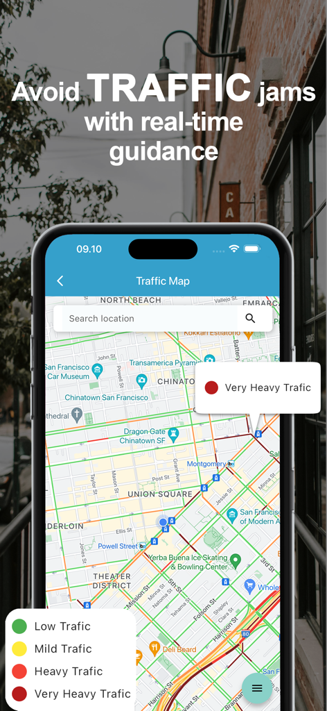
Eine mobile App-Oberfläche, die eine Echtzeit-Verkehrskarte mit farbcodierter Verkehrsdichte und einer Suchleiste zeigt
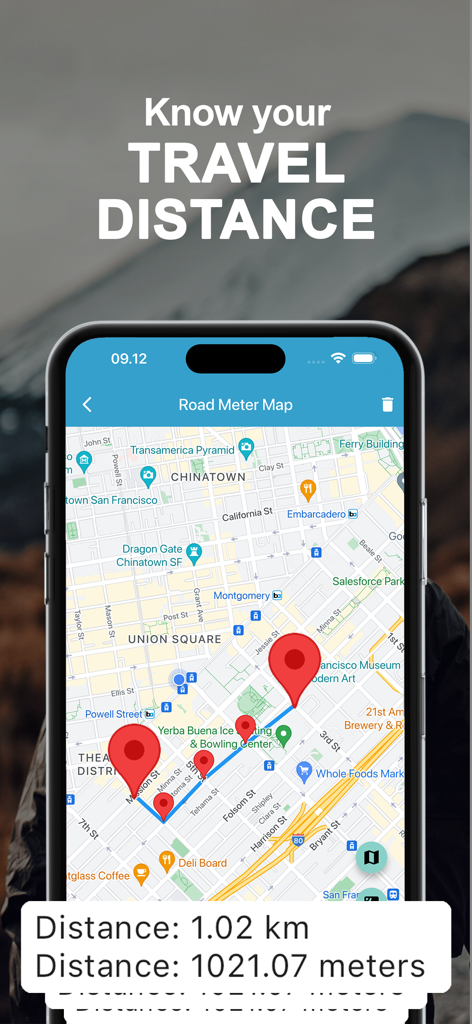
Ein Smartphone, das ein Reiseentfernungsmesswerkzeug mit mehreren Pins auf einer Stadtkarte zeigt und die Gesamtdistanz in Kilometern berechnet.
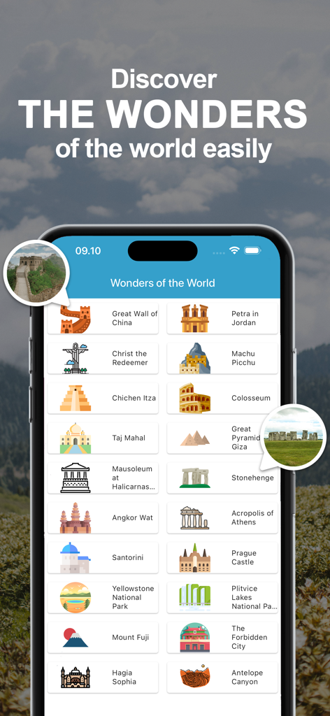
Mobile App-Oberfläche, die eine Liste berühmter globaler Sehenswürdigkeiten und Touristenziele wie die Chinesische Mauer und Machu Picchu anzeigt
Beschreibung
Download
Ähnliche Apps
Top-gerankte Apps in derselben Kategorie

Google Maps
Google LLC

Waze Navigation & Live Traffic
waze

AMap Global
AutoNavi Information Technology Co. Ltd.

百度地图-路线规划,出行必备
Beijing Baidu Netcom Science & Technology Co.,Ltd

Moovit: Bus & Transit Tracker
Moovit App Global LTD

Transit • Subway & Bus Times
9280-0366 Quebec inc.

ParkMobile: Park. Pay. Go.
Parkmobile USA, Inc

腾讯地图-路线规划,导航地铁打车出行
Shenzhen Tencent Computer Systems Company Limited

Île-de-France Mobilités
Ile de France Mobilites
Diese Seite ist keine offizielle Seite der App oder ihres Entwicklers, sondern eine unabhängige redaktionelle Veröffentlichung, die zu Informations- und Kommentarzwecken erstellt wurde. Sofern nicht ausdrücklich anders angegeben, sind weder die App noch ihr Entwickler mit MWM, Apple, Google Play, dem App-Herausgeber oder dem Entwickler der App verbunden, von ihnen unterstützt, gesponsert, autorisiert oder anderweitig offiziell verbunden, und nichts auf dieser Seite impliziert, dass die App unter Verwendung der Dienste von MWM entwickelt wurde. Alle Marken, Logos, Screenshots und andere Inhalte bleiben Eigentum ihrer jeweiligen Inhaber.