Diese Seite ist keine offizielle Seite der App oder ihres Entwicklers, sondern eine unabhängige redaktionelle Veröffentlichung, die zu Informations- und Kommentarzwecken erstellt wurde. Sofern nicht ausdrücklich anders angegeben, sind weder die App noch ihr Entwickler mit MWM, Apple, Google Play, dem App-Herausgeber oder dem Entwickler der App verbunden, von ihnen unterstützt, gesponsert, autorisiert oder anderweitig offiziell verbunden, und nichts auf dieser Seite impliziert, dass die App unter Verwendung der Dienste von MWM entwickelt wurde. Alle Marken, Logos, Screenshots und andere Inhalte bleiben Eigentum ihrer jeweiligen Inhaber.

MapCam - GPS Map Camera
Überlagern Sie sofort GPS-Koordinaten, Zeitstempel und professionelle Metadaten auf Ihren Fotos. Das All-in-One-Dokumentationswerkzeug für Fachleute im Außendienst und Entdecker – entwickelt mit 100 % Datenschutz im Hinterkopf.
Downloads
2K+Bewertung
Bewertungen gesamt
0Herausgeber
Kategorie
NavigationSprachen
12Neueste Version
1.5Größe
37.4 MBErstveröffentlichung
15. Juni 2025Professionelle Präzision in jedem Bild
Das ultimative Geotagging-Tool für Außendienstmitarbeiter und Abenteurer. Erfassen Sie Fotos mit automatischem GPS, Zeitstempeln und Umgebungsdaten, um Ihre Arbeit und Ihre Welt mit absoluter Genauigkeit zu dokumentieren.
Sofortiges Geotagging & Nachweis
Stempeln Sie Fotos automatisch mit Längen- und Breitengrad sowie Zeitstempeln, um stichhaltige Nachweise für Inspektionen, Immobilien oder Reisetagebücher zu liefern.
Umfangreiche Metadaten-Overlays
Gehen Sie über den Standort hinaus mit Höhe, Wetterbedingungen, Luftfeuchtigkeit und Kompassrichtung, die direkt in Ihre hochauflösenden Bilder integriert sind, um den vollständigen Kontext zu erhalten.
Die folgenden Screenshots und die Beschreibung stammen direkt aus dem offiziellen Store-Eintrag der App und sind Eigentum des Entwicklers.
App Store
Screenshots
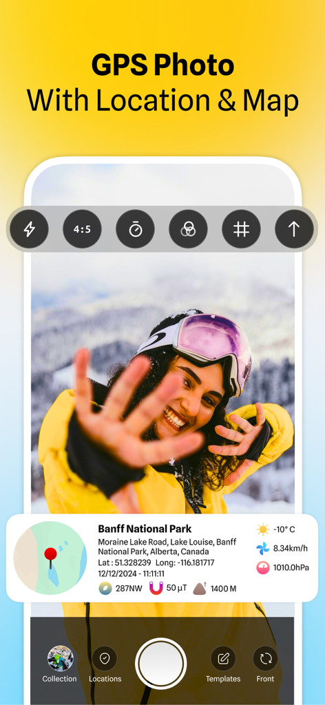
MapCam-Oberfläche zeigt ein Foto mit GPS-Koordinatenkarte und Wetterdaten
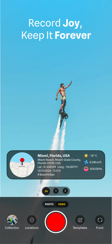
MapCam-App-Oberfläche zeigt einen Flyboarder mit GPS-Standort- und Wetterstempeln
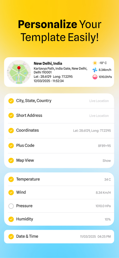
Oberfläche der MapCam-App mit Optionen zur Anpassung von Fotostempeln mit GPS-Koordinaten, Adresse und Wetterdaten
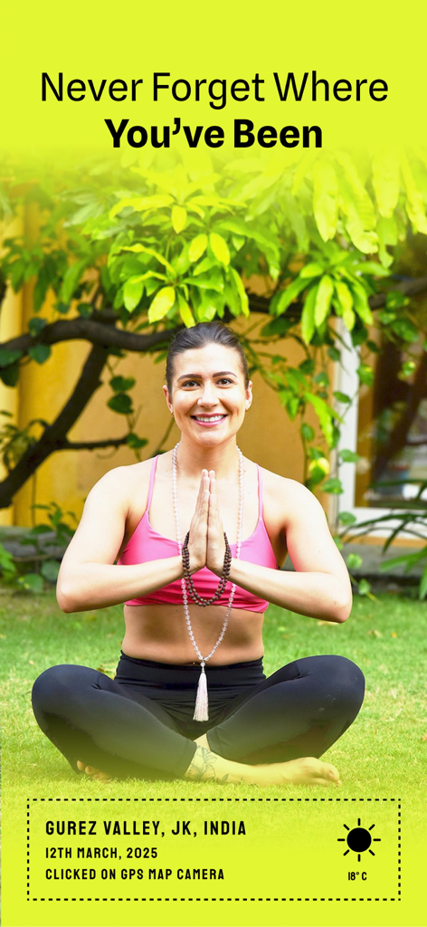
Frau praktiziert Yoga mit einem GPS-Standort- und Datumsstempel-Overlay
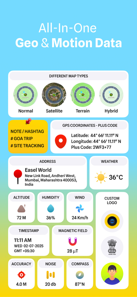
Oberfläche zeigt GPS-Koordinaten, Wetter, Höhe und Kartentypen für Fotos und Videos.
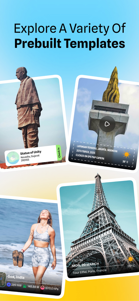
Präsentation verschiedener vordefinierter Vorlagen für das Geotagging von Fotos mit GPS-Standort und Zeitstempeln
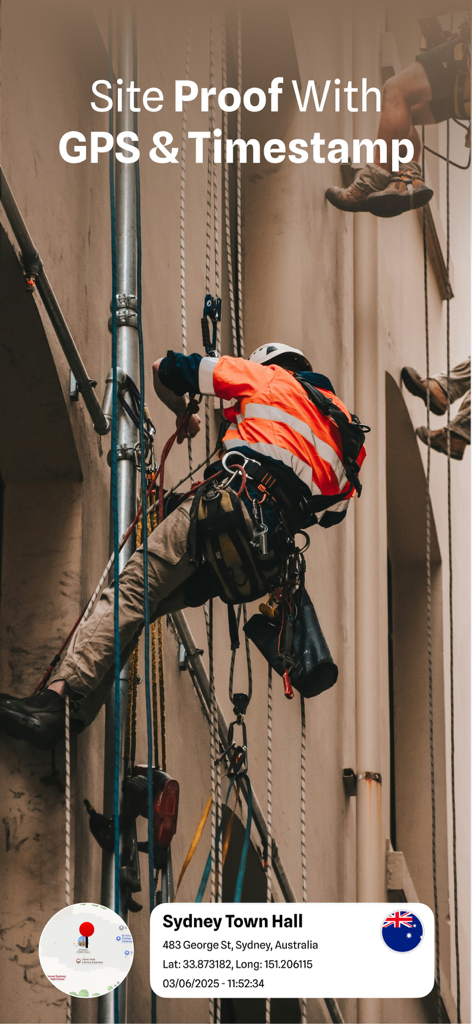
Bauarbeiter dokumentiert den Baustellenfortschritt mit GPS-Koordinaten und Zeitstempel-Overlay
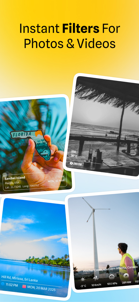
Beispiele für Fotos mit GPS-Standortstempeln und visuellen Filtern aus der MapCam-App
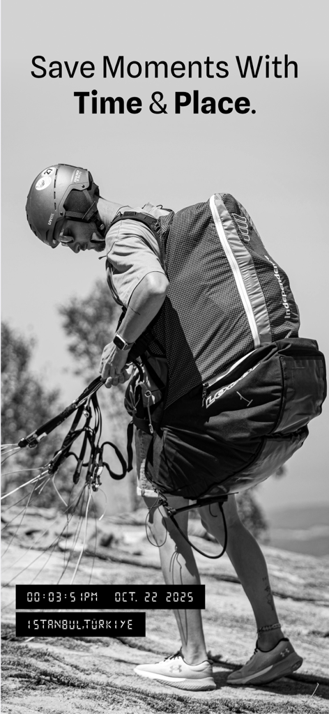
MapCam-App zeigt ein Foto eines Gleitschirmfliegers mit GPS- und Zeitstempel-Tags
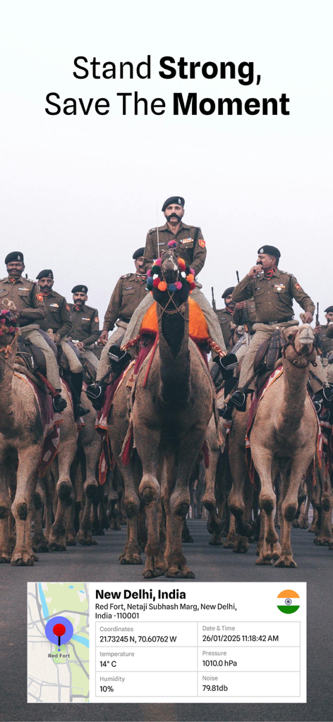
Geotagtes Foto einer Kamelparade in Neu-Delhi mit GPS-Standort und Umweltdaten
Beschreibung
Download
Ähnliche Apps
Top-gerankte Apps in derselben Kategorie

Google Maps
Google LLC

Waze Navigation & Live Traffic
waze

AMap Global
AutoNavi Information Technology Co. Ltd.

百度地图-路线规划,出行必备
Beijing Baidu Netcom Science & Technology Co.,Ltd

Moovit: Bus & Transit Tracker
Moovit App Global LTD

Transit • Subway & Bus Times
9280-0366 Quebec inc.

ParkMobile: Park. Pay. Go.
Parkmobile USA, Inc

腾讯地图-路线规划,导航地铁打车出行
Shenzhen Tencent Computer Systems Company Limited

Île-de-France Mobilités
Ile de France Mobilites
Diese Seite ist keine offizielle Seite der App oder ihres Entwicklers, sondern eine unabhängige redaktionelle Veröffentlichung, die zu Informations- und Kommentarzwecken erstellt wurde. Sofern nicht ausdrücklich anders angegeben, sind weder die App noch ihr Entwickler mit MWM, Apple, Google Play, dem App-Herausgeber oder dem Entwickler der App verbunden, von ihnen unterstützt, gesponsert, autorisiert oder anderweitig offiziell verbunden, und nichts auf dieser Seite impliziert, dass die App unter Verwendung der Dienste von MWM entwickelt wurde. Alle Marken, Logos, Screenshots und andere Inhalte bleiben Eigentum ihrer jeweiligen Inhaber.