Diese Seite ist keine offizielle Seite der App oder ihres Entwicklers, sondern eine unabhängige redaktionelle Veröffentlichung, die zu Informations- und Kommentarzwecken erstellt wurde. Sofern nicht ausdrücklich anders angegeben, sind weder die App noch ihr Entwickler mit MWM, Apple, Google Play, dem App-Herausgeber oder dem Entwickler der App verbunden, von ihnen unterstützt, gesponsert, autorisiert oder anderweitig offiziell verbunden, und nichts auf dieser Seite impliziert, dass die App unter Verwendung der Dienste von MWM entwickelt wurde. Alle Marken, Logos, Screenshots und andere Inhalte bleiben Eigentum ihrer jeweiligen Inhaber.

Measure Map Pro
Das ultimative Kartierungswerkzeug für Ingenieure, Bauunternehmer und Landbesitzer. Berechnen Sie komplexe Umfänge und Flächen mit Erdkrümmungsgenauigkeit und exportieren Sie sofort in AutoCAD-, KML- und GIS-Formate.
Downloads
99K+Bewertung
Bewertungen gesamt
2K+Herausgeber
Kategorie
UtilitiesSprachen
10Neueste Version
13.10.5Größe
239.0 MBErstveröffentlichung
22. Juni 2011Professionelle Kartierung in Ihrer Handfläche
Ersetzen Sie Ihr Maßband durch hochauflösende Satellitentechnologie. Sparen Sie Stunden bei Baustellenbesuchen, indem Sie genaue Flächen, Umfänge und Entfernungen direkt von Ihrem Mobilgerät aus berechnen.
Lasergenaue präzise Messungen
Berücksichtigen Sie die Krümmung der Erde bei der Messung von kleinen Gebäudegrundrissen bis hin zu riesigen tausend Hektar großen Ranches mit einer Genauigkeit von unter einem Meter.
Branchenübliche Exporte
Exportieren Sie Ihre Daten sofort in AutoCAD (DXF), Shapefiles (SHP), KML oder CSV, um Feldmessungen nahtlos in Ihren professionellen CAD- oder GIS-Workflow zu integrieren.
Die folgenden Screenshots und die Beschreibung stammen direkt aus dem offiziellen Store-Eintrag der App und sind Eigentum des Entwicklers.
App Store
Screenshots
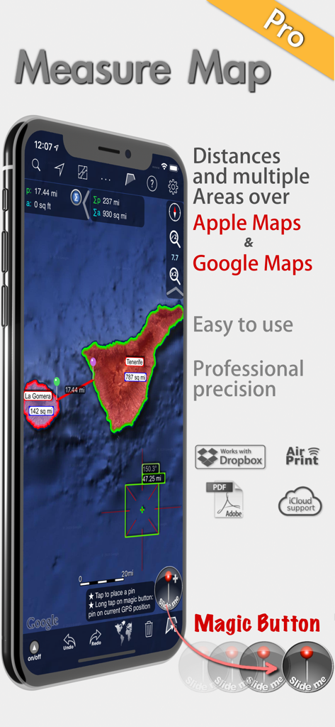
Measure Map Pro App zeigt professionelle Flächen- und Entfernungsmessungen auf Satellitenkarten an
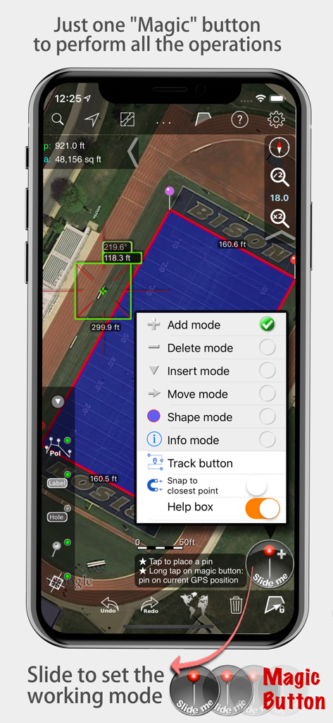
Measure Map Pro App zeigt Flächen- und Entfernungsmessungen auf einer Satellitenkarte mit geöffnetem Magic-Button-Menü an
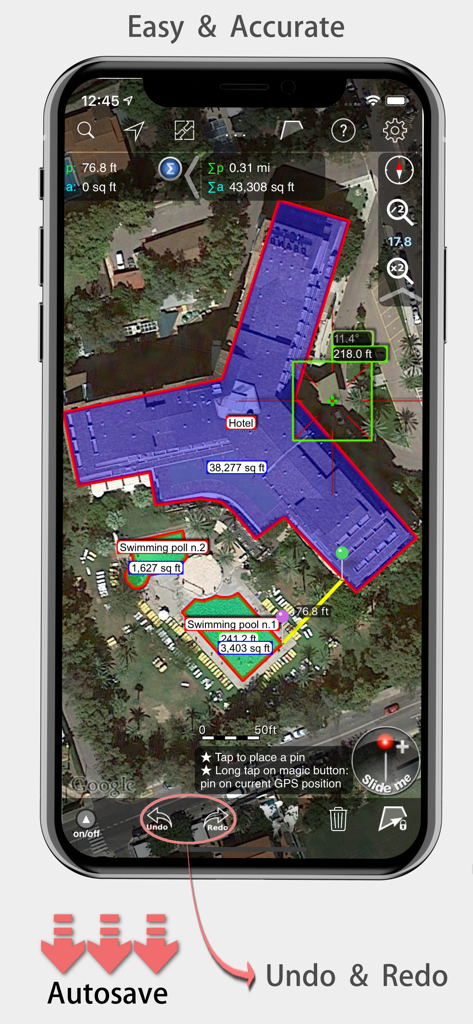
Measure Map Pro mobile App zeigt genaue Flächen- und Entfernungsmessungen eines Hotelgebäudes auf einer Satellitenkarte an.
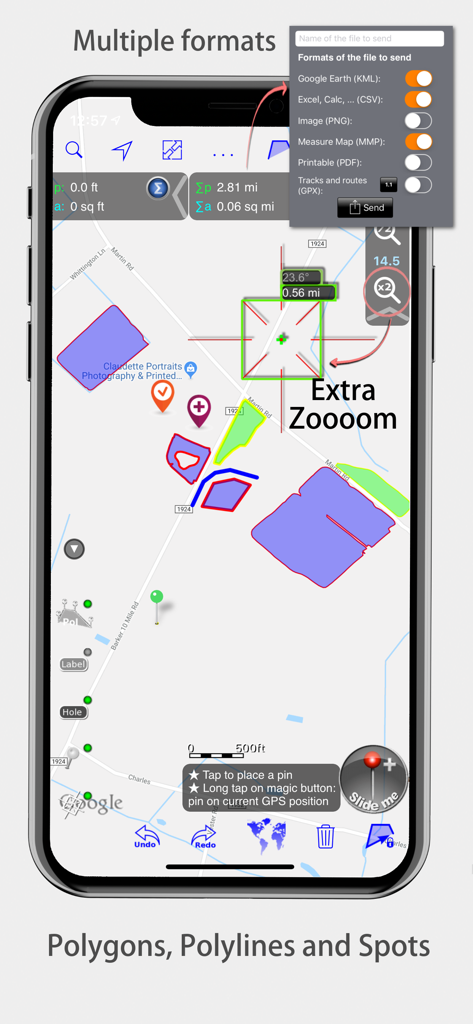
Measure Map Pro-Oberfläche mit Kartenpolygonen und Exportformaten
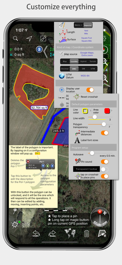
Measure Map Pro mobile App-Oberfläche mit verschiedenen Anpassungsmenüs für Messungen und Kartenstile
Beschreibung
Download
Ähnliche Apps
Apps mit ähnlichen Funktionen und Nutzererfahrung

Field MapS - Measure Land GPS
Aleksei Metelkin

Field Area MeasureーLand Parcel
Irina Metelkina

FieldCalc - GPS Area Measure
Pravin Gondaliya

GPS Fields Area Measure Map
Rento UAB

Geo Field Area - GPS Measure
STOMBERG s.r.o

GLand: GPS Field Area Measure
Authai Yaprasat

Distance - Find My Distance
Mapnitude Company Limited

Area & Distance - Map Measure
Mapnitude Company Limited

Measure Map
Xuan Luong Do
Diese Seite ist keine offizielle Seite der App oder ihres Entwicklers, sondern eine unabhängige redaktionelle Veröffentlichung, die zu Informations- und Kommentarzwecken erstellt wurde. Sofern nicht ausdrücklich anders angegeben, sind weder die App noch ihr Entwickler mit MWM, Apple, Google Play, dem App-Herausgeber oder dem Entwickler der App verbunden, von ihnen unterstützt, gesponsert, autorisiert oder anderweitig offiziell verbunden, und nichts auf dieser Seite impliziert, dass die App unter Verwendung der Dienste von MWM entwickelt wurde. Alle Marken, Logos, Screenshots und andere Inhalte bleiben Eigentum ihrer jeweiligen Inhaber.