Diese Seite ist keine offizielle Seite der App oder ihres Entwicklers, sondern eine unabhängige redaktionelle Veröffentlichung, die zu Informations- und Kommentarzwecken erstellt wurde. Sofern nicht ausdrücklich anders angegeben, sind weder die App noch ihr Entwickler mit MWM, Apple, Google Play, dem App-Herausgeber oder dem Entwickler der App verbunden, von ihnen unterstützt, gesponsert, autorisiert oder anderweitig offiziell verbunden, und nichts auf dieser Seite impliziert, dass die App unter Verwendung der Dienste von MWM entwickelt wurde. Alle Marken, Logos, Screenshots und andere Inhalte bleiben Eigentum ihrer jeweiligen Inhaber.

ok2fly
Beherrschen Sie den australischen Luftraum mit Echtzeit-CASA-Sicherheitsregeln, 4D-NOTAMs und präziser zeitlicher Planung, entwickelt für ernsthafte Hobbyisten und ReOC-Inhaber.
Downloads
43K+Bewertung
Bewertungen gesamt
0Herausgeber
Kategorie
NavigationSprachen
1Neueste Version
1.6.0Größe
75.6 MBErstveröffentlichung
12. Jan. 2022Planen Sie Ihre Mission mit absoluter Zuversicht
Das ultimative Sicherheitstool für professionelle und Freizeit-Drohnenpiloten, das CASA-konforme Daten mit hochpräziser 4D-Situationswahrnehmung kombiniert, um Ihre Ausrüstung und Ihre Lizenz zu schützen.
Offizielle CASA-integrierte Compliance
Fliegen Sie mit völliger Sorgenfreiheit mit einem Tool, das vollständig in die CASA RPAS-Plattform integriert ist. Bleiben Sie konform mit den aktuellen Sicherheitsregeln und greifen Sie direkt auf offizielle Autorisierungsversuche von Airservices Australia zu.
Hyperlokale Situationswahrnehmung
Erhalten Sie mehr als nur ein 'grünes Licht'. Visualisieren Sie 4D-beschränkte Lufträume, Flughafenumgebungen und Echtzeit-NOTAMs sowie lokale Wahrzeichen wie Schulen, Gefängnisse und Parks, um Rechtsstreitigkeiten zu vermeiden.
Häufig gestellte Fragen
Alles, was Sie über wissen müssen ok2fly
Was ist ok2fly?
ok2fly ist ein Werkzeug zur Drohnensicherheit, das Piloten bei der Missionsplanung, der Visualisierung des Luftraums und der Einhaltung von Vorschriften hilft. Es bietet detaillierte Karten und eine Echtzeitanalyse der Betriebsumgebung.
Zeigt ok2fly Drohnen-No-Fly-Zonen an?
Ja, ok2fly bietet eine detaillierte Visualisierung von Landebahnverlängerungen, Flughafenumgebungen und visualisiert automatisch eingeschränkte und gefährliche Bereiche. Es identifiziert No-Fly-Zonen basierend auf aktiven Flugverkehrskontrolltürmen.
Wie hilft ok2fly bei der Flugplanung?
ok2fly untersucht das unmittelbare Drohnenfluggebiet mit einem konfigurierbaren Radius, liefert detaillierte Standortberichte und passt die Karteninformationen an, um die Aktivität zur geplanten Flugzeit widerzuspiegeln.
Ist ok2fly konform mit den CASA-Vorschriften für Drohnenflüge?
Ja, ok2fly entspricht vollständig den CASA RPAS Safety Rules und integriert sich in die CASA RPAS Platform. Es war Teil des CASA / Airservices Australia Airspace Authorisation Trials.
Kann ok2fly einen detaillierten Flugbericht erstellen?
Ja, ok2fly analysiert den Luftraum rund um Ihren Standort und liefert einen detaillierten Standortbericht. Dieser Bericht enthält alle bekannten Landmarken, die im operativen Luftraum erfasst wurden.
Zeigt ok2fly an, ob ich meine Drohne fliegen darf?
Ja, ok2fly liefert klare Anzeigen wie "OK 2 Fly", "Kann nicht fliegen" oder "Kann fliegen – mit Bedingungen" basierend auf der Analyse des geplanten Fluggebiets und der ausgewählten Pilotenqualifikationen.
Welche Kartendaten liefert ok2fly für Australien?
ok2fly bietet eine Vektorkarte auf Straßenebene für ganz Australien. Sie enthält Standardstraßeninformationen, Luftfahrtdetails wie Hindernisse, niedrigfliegende Luftaktivitäten und Erholungsgebiete.
Kann ich in ok2fly Overlays zur Karte hinzufügen?
Ja, ok2fly unterstützt zusätzliche Karten-Overlays, einschließlich dynamischer Optionen wie Flugverkehr, Wetter und Blitze. Statische Overlays wie FIA-Frequenzgrenzen und kontrollierter Luftraum sind ebenfalls verfügbar.
Zeigt ok2fly Echtzeit-NOTAMs für Drohnenoperationen an?
Ja, ok2fly visualisiert automatisch NOTAM-Aktivitäten, die Drohnenoperationen beeinträchtigen. Es bietet auch kontinuierlich aktualisierte NAIPS NOTAM-Informationen für eingeschränkte und gefährliche Lufträume mit einem kostenpflichtigen Abonnement.
Kann ich ok2fly für meine spezifischen Drohnenpilotenqualifikationen konfigurieren?
Ja, ok2fly unterstützt vier CASA-Pilottypen: Micro, Recreational, Commercial Excluded und ReOC. Benutzer können ihren Pilotentyp über die Einstellungsfunktion festlegen, um ihren Qualifikationen zu entsprechen.
Benötigt ok2fly ein kostenpflichtiges Abonnement für alle Funktionen?
Nein, einige erweiterte Funktionen in ok2fly erfordern ein kostenpflichtiges Abonnement. Dazu gehören die Pilotentypen Commercial Excluded und ReOC, die Option Layers, die NAIPS NOTAM-Inspektion und Funkfrequenzdaten.
Was ist in einem kostenpflichtigen ok2fly-Abonnement enthalten?
Ein kostenpflichtiges ok2fly-Abonnement beinhaltet den Zugriff auf Funktionen wie Commercial Excluded/ReOC-Pilotentypen, erweiterte Karten-Layer, NAIPS NOTAM-Inspektion, Funkfrequenzdaten und AvPlan-EFB Standard Plus-Zugang.
Bietet ok2fly verschiedene Anzeigemodi?
Ja, ok2fly bietet sowohl helle als auch dunkle Anzeigemodi für die Benutzerpräferenz. Benutzer können zwischen diesen Modi wechseln, um die Sichtbarkeit bei unterschiedlichen Lichtverhältnissen zu optimieren.
Ist AvSoft Australia, der Anbieter von ok2fly, ein zertifizierter Datenanbieter?
Ja, AvSoft Australia, der Entwickler von ok2fly, ist ein von CASA Part 175 zugelassener Datenanbieter. Dies gewährleistet, dass die Daten der App maßgeblich und konform mit den Luftfahrtstandards sind.
Die folgenden Screenshots und die Beschreibung stammen direkt aus dem offiziellen Store-Eintrag der App und sind Eigentum des Entwicklers.
App Store
Screenshots
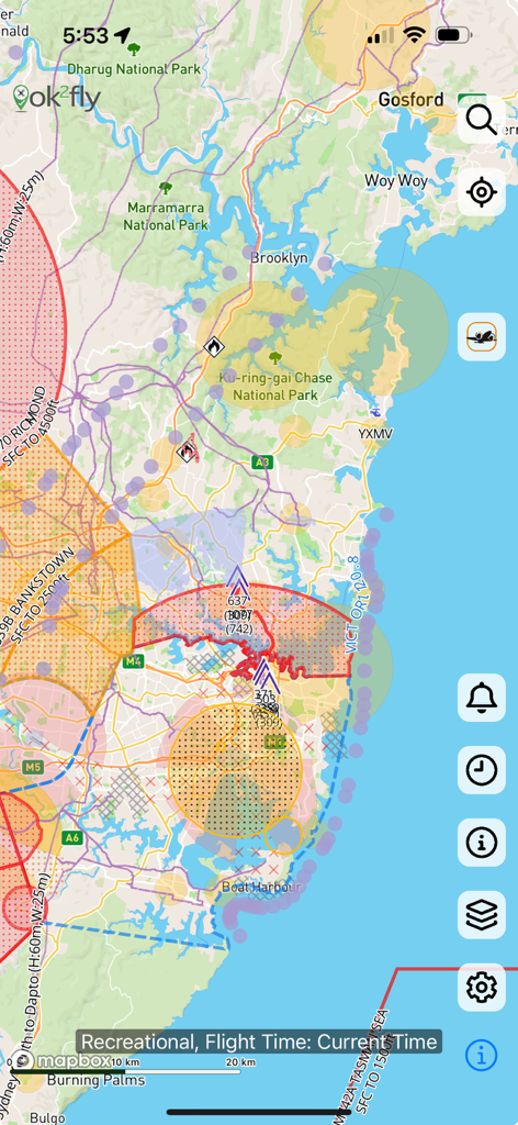
Eine detaillierte Drohnen-Luftraumkarte, die eingeschränkte Flugzonen und Sicherheitsinformationen in der ok2fly-App anzeigt
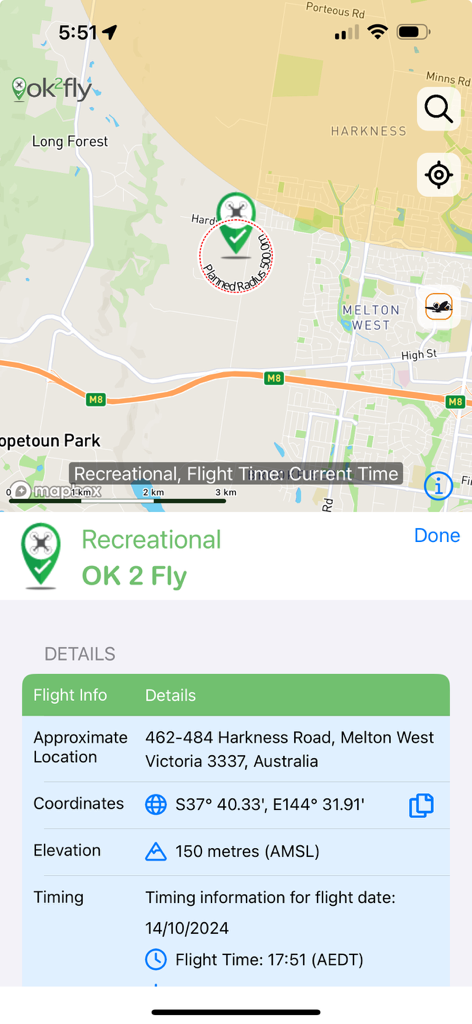
Ein Screenshot der ok2fly-App, der eine Karte und Details zur Planung von Freizeitdrohnenflügen zeigt.
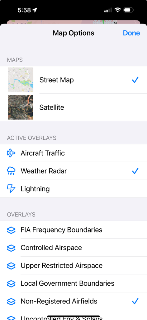
Einstellungsbildschirm der Karte in der ok2fly-App, der Optionen für Straßenkarten, Satellitenansichten und Luftfahrt-Overlays wie Wetterradar und kontrollierte Lufträume anzeigt
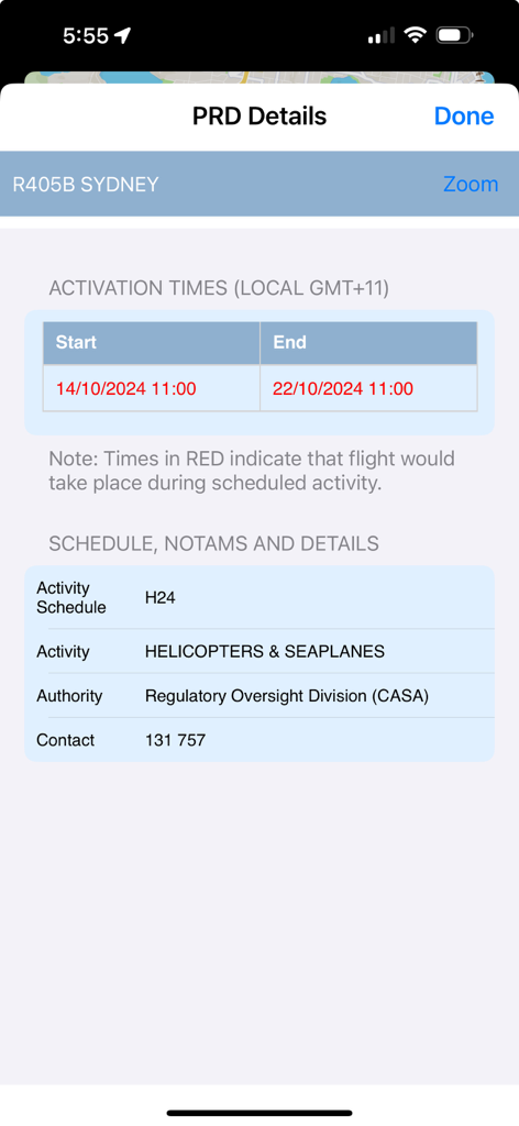
Die ok2fly-App zeigt PRD-Details für Sydney an, einschließlich Aktivierungszeiten und Zeitpläne für Hubschrauberaktivitäten
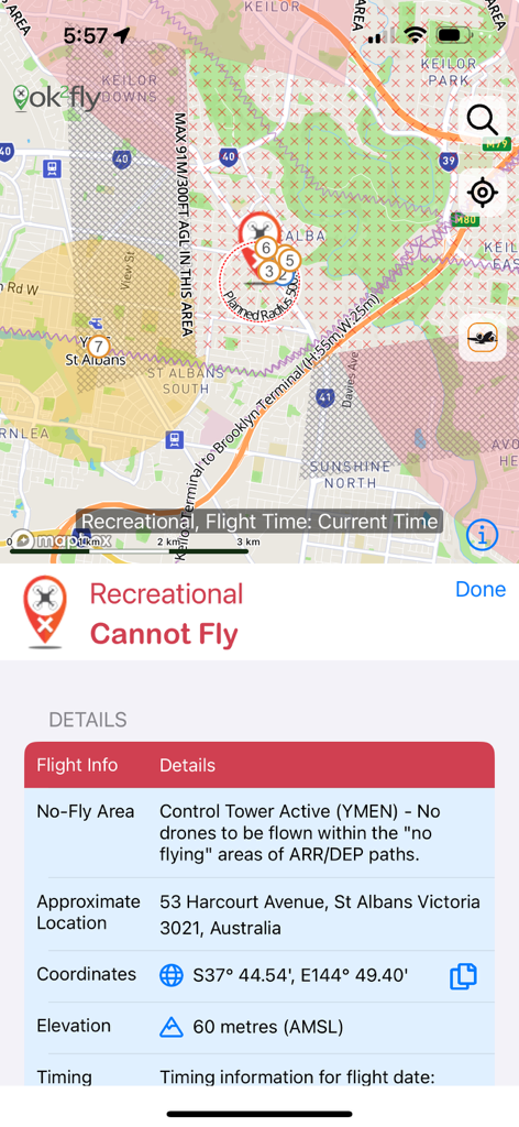
Screenshot der ok2fly-App, der eine Drohnen-No-Fly-Zone aufgrund eines aktiven Kontrollturms in Australien zeigt
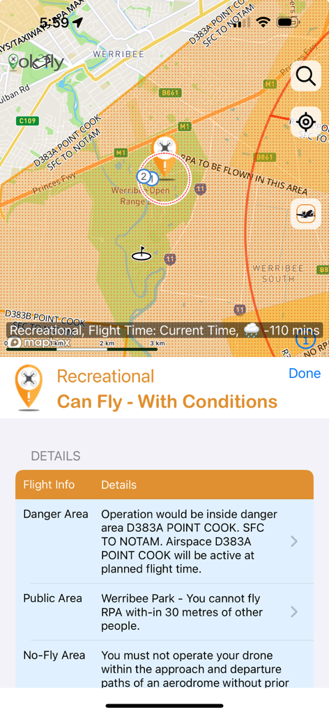
Screenshot der ok2fly-App, der Drohnenflug-Sicherheitsbedingungen und eine Karte für Freizeitpiloten anzeigt
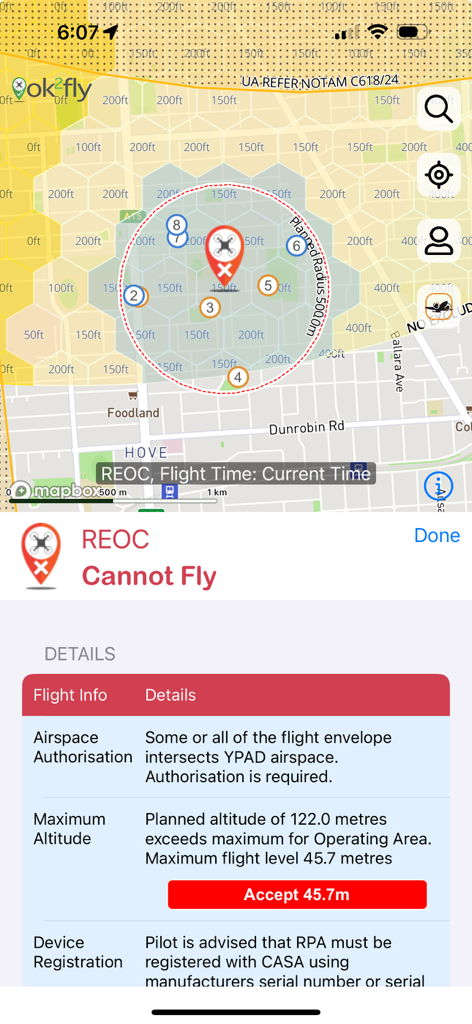
Screenshot der ok2fly-App, der eine Karte mit eingeschränkten Drohnenflugzonen und detaillierte Sicherheitshinweise für REOC-Piloten anzeigt.
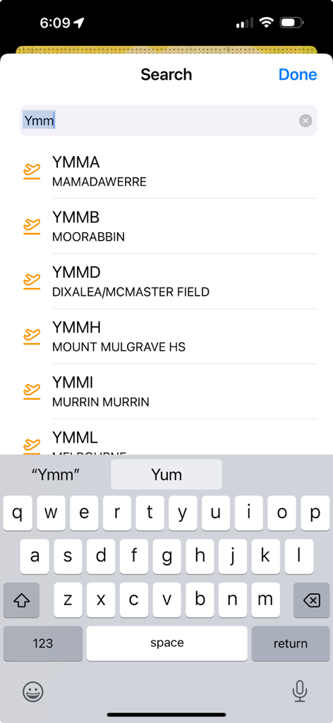
Der Suchbildschirm der ok2fly-App zeigt eine Liste von australischen Flughafencodes und -namen an
Beschreibung
Download
Ähnliche Apps
Top-gerankte Apps in derselben Kategorie

Google Maps
Google LLC

Waze Navigation & Live Traffic
waze

AMap Global
AutoNavi Information Technology Co. Ltd.

百度地图-路线规划,出行必备
Beijing Baidu Netcom Science & Technology Co.,Ltd

Moovit: Bus & Transit Tracker
Moovit App Global LTD

Transit • Subway & Bus Times
9280-0366 Quebec inc.

ParkMobile: Park. Pay. Go.
Parkmobile USA, Inc

腾讯地图-路线规划,导航地铁打车出行
Shenzhen Tencent Computer Systems Company Limited

Île-de-France Mobilités
Ile de France Mobilites
Diese Seite ist keine offizielle Seite der App oder ihres Entwicklers, sondern eine unabhängige redaktionelle Veröffentlichung, die zu Informations- und Kommentarzwecken erstellt wurde. Sofern nicht ausdrücklich anders angegeben, sind weder die App noch ihr Entwickler mit MWM, Apple, Google Play, dem App-Herausgeber oder dem Entwickler der App verbunden, von ihnen unterstützt, gesponsert, autorisiert oder anderweitig offiziell verbunden, und nichts auf dieser Seite impliziert, dass die App unter Verwendung der Dienste von MWM entwickelt wurde. Alle Marken, Logos, Screenshots und andere Inhalte bleiben Eigentum ihrer jeweiligen Inhaber.