Diese Seite ist keine offizielle Seite der App oder ihres Entwicklers, sondern eine unabhängige redaktionelle Veröffentlichung, die zu Informations- und Kommentarzwecken erstellt wurde. Sofern nicht ausdrücklich anders angegeben, sind weder die App noch ihr Entwickler mit MWM, Apple, Google Play, dem App-Herausgeber oder dem Entwickler der App verbunden, von ihnen unterstützt, gesponsert, autorisiert oder anderweitig offiziell verbunden, und nichts auf dieser Seite impliziert, dass die App unter Verwendung der Dienste von MWM entwickelt wurde. Alle Marken, Logos, Screenshots und andere Inhalte bleiben Eigentum ihrer jeweiligen Inhaber.

RadarScope
Erleben Sie rohe NEXRAD Level II-Daten und native Radarprodukte mit null Latenz. Verfolgen Sie Tornados, Hurrikans und schwere Stürme mit denselben hochauflösenden Werkzeugen, denen Meteorologen und Ersthelfer vertrauen.
Downloads
408K+Bewertung
Bewertungen gesamt
5K+Herausgeber
Kategorie
WeatherSprachen
4Neueste Version
5.5.2Größe
288.4 MBErstveröffentlichung
12. Feb. 2019Professionelle Radarvisualisierung
Greifen Sie auf rohe, hochauflösende Radardaten und fortschrittliche Sturmverfolgungswerkzeuge zu, die für Profis und Enthusiasten entwickelt wurden, die Genauigkeit über Ästhetik stellen.
Rohe NEXRAD Level II-Daten
Sehen Sie Radardaten in ihrem ursprünglichen radialen Format ohne Glättung, sodass Sie Geschwindigkeits-Kopplungen und Trümmerbälle mit null Latenz identifizieren können.
Echtzeit-Schwerwarnungen
Überwachen Sie vom NWS generierte Warnungen für Tornados, Sturzfluten und schwere Gewitter mit integrierten Sturmbahnen und Hagelattributen.
Die folgenden Screenshots und die Beschreibung stammen direkt aus dem offiziellen Store-Eintrag der App und sind Eigentum des Entwicklers.
App Store
Screenshots
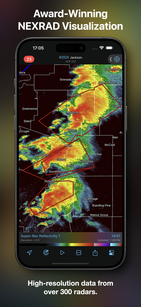
RadarScope App zeigt hochauflösende NEXRAD-Radardaten auf einem mobilen Gerät.
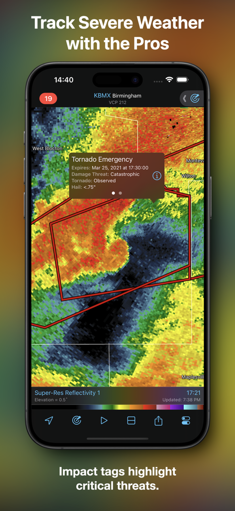
RadarScope App zeigt eine Tornado-Notfall-Impact-Markierung auf einer Wetterradarkarte.
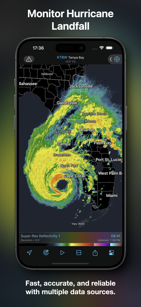
RadarScope App-Oberfläche zeigt eine hochauflösende Hurrikan-Radar-Schleife über Florida.
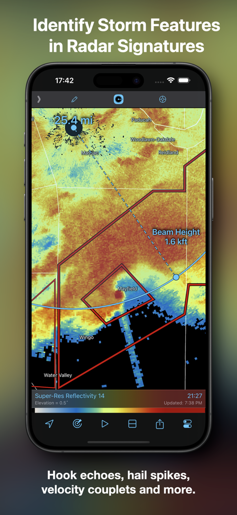
RadarScope App-Screenshot zeigt eine Radarkarte mit Entfernungs- und Strahlhöhenmarkierungen zur Identifizierung von Sturmmerkmalen.
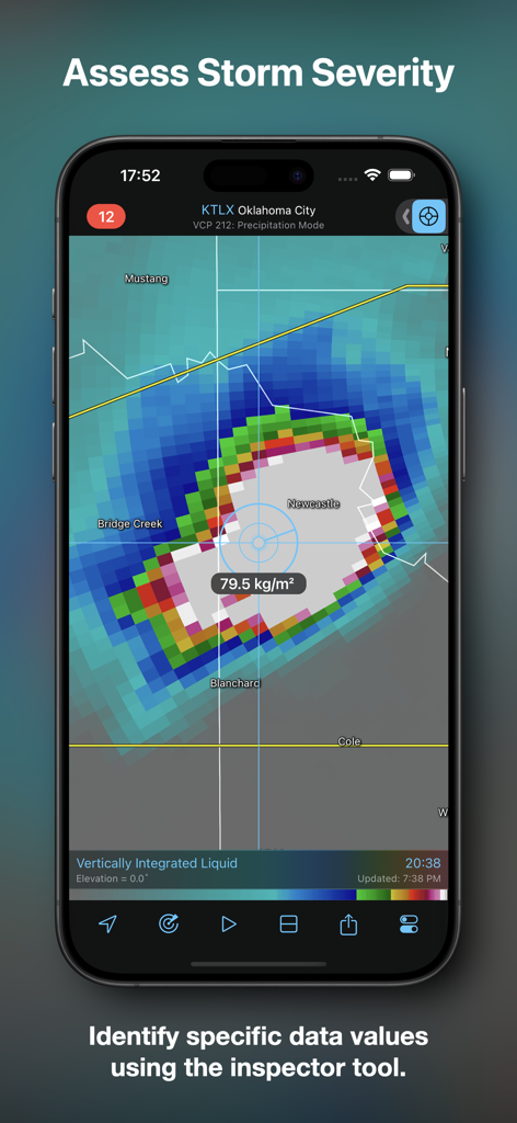
RadarScope App-Oberfläche zeigt die Bewertung der Sturmintensität mit dem Inspektor-Tool.
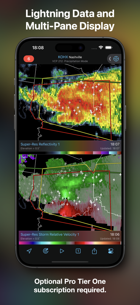
Screenshot der RadarScope App, der eine geteilte Ansicht mit Super-Res-Reflektivität und sturmrelativer Geschwindigkeit einschließlich Blitzdaten zeigt.
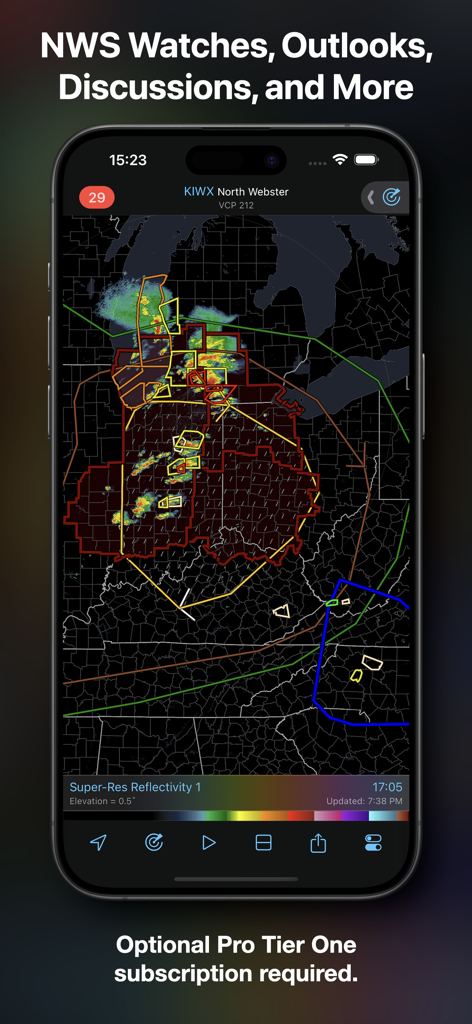
RadarScope App-Oberfläche zeigt National Weather Service Watch- und Outlook-Informationen auf einer hochauflösenden Radarkarte
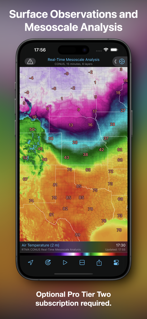
RadarScope App zeigt Echtzeit-Mesoskalenanalysen und Bodenoberflächentemperaturbeobachtungen
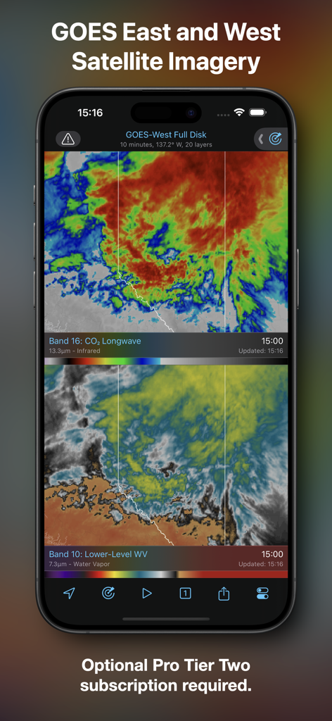
RadarScope mobile App zeigt GOES Ost- und West-Satellitenbilder mit Infrarot- und Wasserdampfschichten
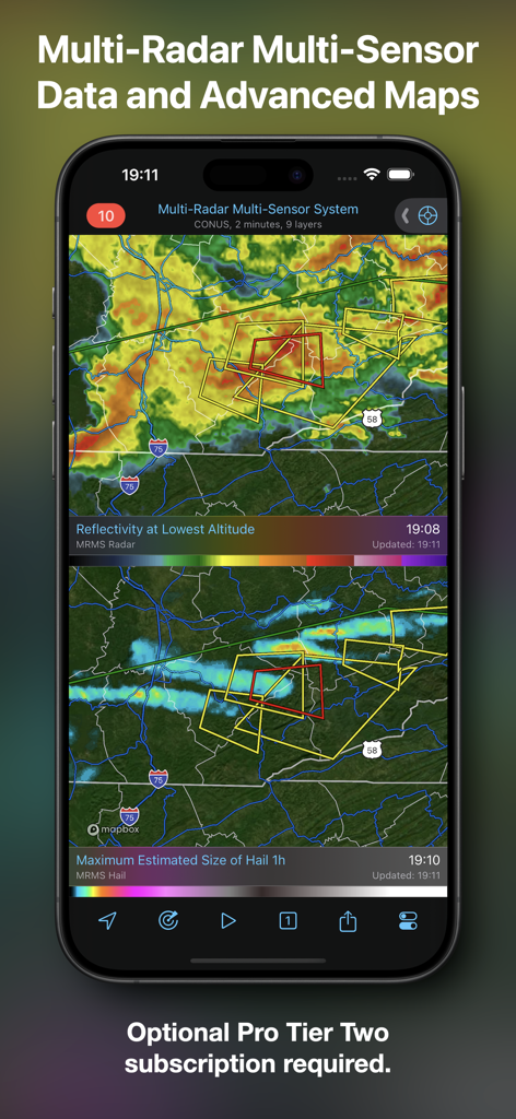
RadarScope App-Oberfläche zeigt fortschrittliche Wetterkarten mit Reflektivitäts- und Hagelgrößen-Daten.
Beschreibung
Download
Ähnliche Apps
Apps mit ähnlichen Funktionen und Nutzererfahrung

墨迹天气-MojiWeather
Beijing MojiFengyun Technology Co.,Ltd.

Windy.com
Windyty, SE

天气通
Weibo Internet Technology (China) Co.Ltd.

Zoom Earth - Weather Forecast
Neave Interactive Limited

实时天气-40日精准天气实时预报
犇 牛

MyRadar Accurate Weather Radar
Aviation Data Systems, Inc

Ventusky: Weather & Live Radar
Ventusky s.r.o.

FOX Weather: Daily Forecasts
Fox News Network, LLC

2345天气王-天气和空气质量查询小组件
Shanghai 2345 Network Technology Co., Ltd.
Diese Seite ist keine offizielle Seite der App oder ihres Entwicklers, sondern eine unabhängige redaktionelle Veröffentlichung, die zu Informations- und Kommentarzwecken erstellt wurde. Sofern nicht ausdrücklich anders angegeben, sind weder die App noch ihr Entwickler mit MWM, Apple, Google Play, dem App-Herausgeber oder dem Entwickler der App verbunden, von ihnen unterstützt, gesponsert, autorisiert oder anderweitig offiziell verbunden, und nichts auf dieser Seite impliziert, dass die App unter Verwendung der Dienste von MWM entwickelt wurde. Alle Marken, Logos, Screenshots und andere Inhalte bleiben Eigentum ihrer jeweiligen Inhaber.