Diese Seite ist keine offizielle Seite der App oder ihres Entwicklers, sondern eine unabhängige redaktionelle Veröffentlichung, die zu Informations- und Kommentarzwecken erstellt wurde. Sofern nicht ausdrücklich anders angegeben, sind weder die App noch ihr Entwickler mit MWM, Apple, Google Play, dem App-Herausgeber oder dem Entwickler der App verbunden, von ihnen unterstützt, gesponsert, autorisiert oder anderweitig offiziell verbunden, und nichts auf dieser Seite impliziert, dass die App unter Verwendung der Dienste von MWM entwickelt wurde. Alle Marken, Logos, Screenshots und andere Inhalte bleiben Eigentum ihrer jeweiligen Inhaber.

Route Planner - GPS MGRS UTM
Beherrschen Sie das Gelände mit militärischen MGRS-Gittern, fortschrittlicher Koordinatenprojektion und Offline-Topografiekarten, die für taktische Experten und Outdoor-Profis entwickelt wurden.
Downloads
5K+Bewertung
Bewertungen gesamt
0Herausgeber
Kategorie
NavigationSprachen
4Neueste Version
2.0.2Größe
83.1 MBErstveröffentlichung
14. Apr. 2025Präzisionswerkzeuge für taktische und Feldeinsätze
Schließen Sie die Lücke zwischen Verbrauchernavigation und professionellem GIS. Unsere Suite hochpräziser Werkzeuge ist für Militärpersonal, Feldforscher und Backcountry-Profis konzipiert, die Zuverlässigkeit in den abgelegensten Umgebungen benötigen.
Militärische Koordinatenpräzision
Wechseln Sie sofort zwischen MGRS, UTM und Längen-/Breitengraden. Führen Sie taktische Koordinatenprojektionen basierend auf Peilung und Entfernung für punktgenaue Genauigkeit im Feld durch.
Nahtlose GIS-Datenintegration
Standardisieren Sie Ihren Workflow durch Import und Export von KML-, GPX- und GeoJSON-Dateien. Verwalten Sie komplexe räumliche Daten mit benutzerdefinierten Ebenen, Polygonen und professionellen Kartenannotationen.
Die folgenden Screenshots und die Beschreibung stammen direkt aus dem offiziellen Store-Eintrag der App und sind Eigentum des Entwicklers.
App Store
Screenshots
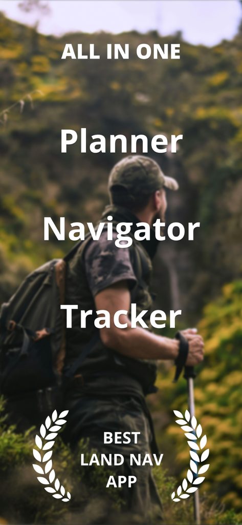
Ein Wanderer in taktischer Ausrüstung in der Wildnis mit Text, der die App als All-in-One-Planer, Navigator und Tracker beschreibt
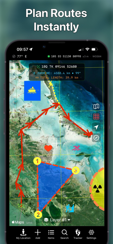
Smartphone zeigt die Routenplaner-App mit taktischer Kartenroutenzeichnung und MGRS-Koordinaten an
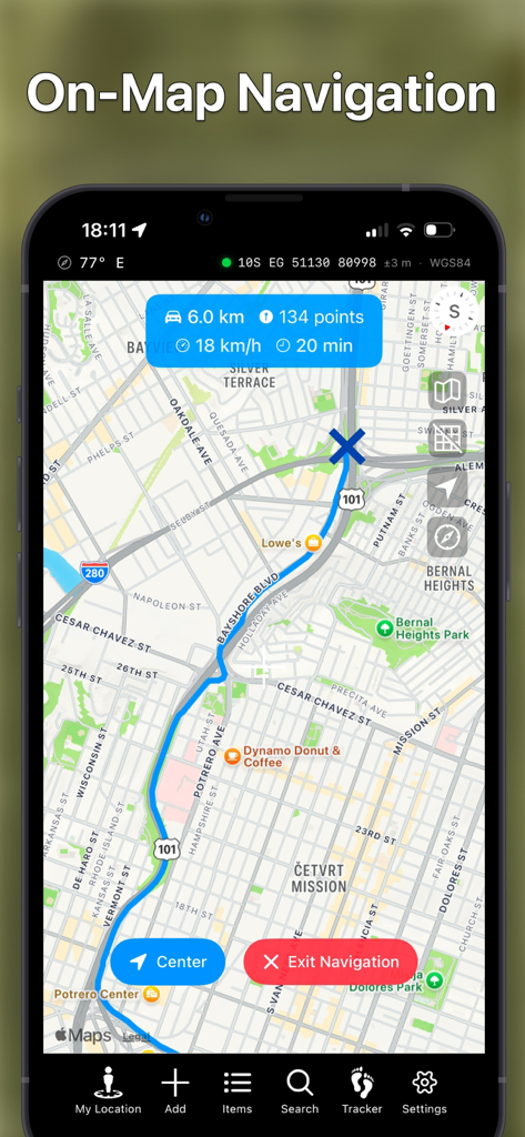
Screenshot der mobilen App, der die Navigation auf der Karte mit einer blauen Route und MGRS-Koordinaten zeigt
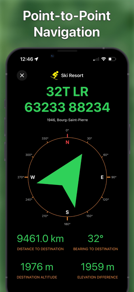
Taktische Punkt-zu-Punkt-Navigationsschnittstelle mit MGRS-Koordinaten und Kompasspeilung
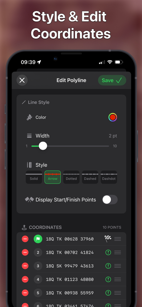
Schnittstelle zum Stylen von Kartenrouten und Verwalten von MGRS-Koordinatenpunkten
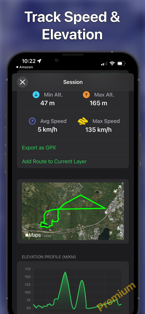
App-Oberfläche zeigt Geschwindigkeits- und Höhenverfolgungsstatistiken mit einer Routenkarte und einem Höhenprofil an
Beschreibung
Download
Ähnliche Apps
Top-gerankte Apps in derselben Kategorie

Google Maps
Google LLC

Waze Navigation & Live Traffic
waze

AMap Global
AutoNavi Information Technology Co. Ltd.

百度地图-路线规划,出行必备
Beijing Baidu Netcom Science & Technology Co.,Ltd

Moovit: Bus & Transit Tracker
Moovit App Global LTD

Transit • Subway & Bus Times
9280-0366 Quebec inc.

ParkMobile: Park. Pay. Go.
Parkmobile USA, Inc

腾讯地图-路线规划,导航地铁打车出行
Shenzhen Tencent Computer Systems Company Limited

Île-de-France Mobilités
Ile de France Mobilites
Diese Seite ist keine offizielle Seite der App oder ihres Entwicklers, sondern eine unabhängige redaktionelle Veröffentlichung, die zu Informations- und Kommentarzwecken erstellt wurde. Sofern nicht ausdrücklich anders angegeben, sind weder die App noch ihr Entwickler mit MWM, Apple, Google Play, dem App-Herausgeber oder dem Entwickler der App verbunden, von ihnen unterstützt, gesponsert, autorisiert oder anderweitig offiziell verbunden, und nichts auf dieser Seite impliziert, dass die App unter Verwendung der Dienste von MWM entwickelt wurde. Alle Marken, Logos, Screenshots und andere Inhalte bleiben Eigentum ihrer jeweiligen Inhaber.