Diese Seite ist keine offizielle Seite der App oder ihres Entwicklers, sondern eine unabhängige redaktionelle Veröffentlichung, die zu Informations- und Kommentarzwecken erstellt wurde. Sofern nicht ausdrücklich anders angegeben, sind weder die App noch ihr Entwickler mit MWM, Apple, Google Play, dem App-Herausgeber oder dem Entwickler der App verbunden, von ihnen unterstützt, gesponsert, autorisiert oder anderweitig offiziell verbunden, und nichts auf dieser Seite impliziert, dass die App unter Verwendung der Dienste von MWM entwickelt wurde. Alle Marken, Logos, Screenshots und andere Inhalte bleiben Eigentum ihrer jeweiligen Inhaber.

Hiking Maps - PeakVisor
Das ultimative visuelle Toolkit für Entdecker. Bestimme über eine Million Gipfel, navigiere mit modernster 3D-Geländemodellierung und tracke deine Wander- oder Skiabenteuer mit professionellem GPS – alles offline verfügbar.
Downloads
2M+Bewertung
Bewertungen gesamt
62K+Herausgeber
Kategorie
TravelSprachen
14Neueste Version
5.73Größe
150.6 MBErstveröffentlichung
21. Dez. 2016Meistere jeden Gipfel mit modernsten Tools
PeakVisor verwandelt dein Smartphone in ein hochpräzises Navigationssystem und kombiniert Augmented Reality mit 3D-Geländemodellierung, um jedes Bergabenteuer zu bereichern.
Sofortige Gipfelbestimmung
Richte deine Kamera aus, um über eine Million Gipfel sofort zu identifizieren. Erhalte Namen, Höhen und detaillierte Geländedaten, selbst ohne Mobilfunkempfang.
Hochpräzise 3D-Karten
Navigiere sicher mit Topo-Karten der nächsten Generation. Visualisiere Wegsteilheit und Geländenuancen in einer immersiven 3D-Welt.
Häufig gestellte Fragen
Alles, was Sie über wissen müssen Hiking Maps - PeakVisor
Was ist PeakVisor?
PeakVisor ist eine Bergnavigations-App, die hochmoderne Gipfelerkennung, 3D-Karten, Wanderwege und GPS-Tracking im Freien bietet. Sie ist für Aktivitäten wie Wandern, Skifahren und Klettern konzipiert und bietet ein detailliertes 3D-Berg-Erlebnis.
Verwendet PeakVisor Augmented Reality zur Gipfelerkennung?
Ja, PeakVisor verwendet Augmented-Reality-Technologie (AR). Es überlagert Namen und Höhen von nahegelegenen Gipfeln direkt auf die Kameraansicht Ihres iPhones zur Echtzeit-Identifizierung.
Wie viele Berge kann PeakVisor identifizieren?
PeakVisor kann weltweit über eine Million Berge, Hügel, Buttes und Nadeln identifizieren. Es bietet detaillierte Profile, einschließlich Höhe, topografische Prominenz, Gebirge und zusätzliche Wikipedia-Artikel.
Kann ich Wanderrouten mit PeakVisor planen?
Ja, PeakVisor ermöglicht die Planung von Wanderrouten mit seinen 3D-Karten und seinem riesigen Wegenetz. Es hilft bei der Bewertung der erwarteten Distanz, Höhenprofile und geschätzten Abschlusszeiten für Ihr Abenteuer.
Welche Skifunktionen bietet PeakVisor?
PeakVisor bietet topografische 3D-Karten zum Skifahren, die Berglifte, Skipisten und backcountry-Routen detailliert darstellen. Es enthält auch einen Wintermodus und eine Überlagerung der Hangneigung zur Identifizierung von Lawinengelände.
Zeigt PeakVisor Informationen zu Seilbahnen und Berghütten an?
Ja, die 3D-Karten von PeakVisor umfassen Seilbahnen und Berghütten mit ihren Fahrplänen. Diese Funktion unterstützt die Planung von Bergzielen, insbesondere in europäischen Regionen.
Kann PeakVisor meine Outdoor-Aktivitäten verfolgen?
Ja, PeakVisor bietet GPS-Tracking für Outdoor-Abenteuer wie Wandern, Skifahren und Mountainbiken. Sie können Ihre Route in 3D visualisieren, Statistiken wie Distanz und Höhengewinn anzeigen und GPX-Dateien exportieren.
Ist PeakVisor auch ohne Internetverbindung funktionsfähig?
Ja, alle Funktionen von PeakVisor funktionieren offline. Benutzer können topografische Kartendaten für Regionen wie die Alpen herunterladen, um die volle Funktionalität ohne Internetverbindung zu gewährleisten.
Wie kann ich alle PeakVisor-Funktionen uneingeschränkt nutzen?
Benutzer können alle PeakVisor-Funktionen uneingeschränkt nutzen, indem sie PeakVisor PRO abonnieren. Dieses Premium-Abonnement ist monatlich oder jährlich verfügbar.
Zeigt die PeakVisor-App Werbung an?
Nein, die PeakVisor-App zeigt keine Werbung an. Alle Einnahmen der App stammen aus Benutzerabonnements für PeakVisor PRO.
Kann ich Berge in meinen Fotos mit PeakVisor markieren?
Ja, PeakVisor ermöglicht es Ihnen, Berge in Ihren Fotos mit seiner AR-Technologie zu markieren. Sie können Gipfelnamen und Höhen auf Ihre Bilder überlagern und diese speichern.
Bietet PeakVisor animierte Überflug-Videos von Routen an?
Ja, PeakVisor bietet die Funktion „Animiertes Überflug-Video“. Benutzer können eine visuell beeindruckende Animation ihrer Route starten, um sie mit anderen zu teilen oder Erinnerungen wieder aufleben zu lassen.
Die folgenden Screenshots und die Beschreibung stammen direkt aus dem offiziellen Store-Eintrag der App und sind Eigentum des Entwicklers.
App Store
Screenshots
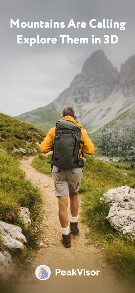
Ein Wanderer auf einem Bergpfad mit dem Text Die Berge rufen – Entdecke sie in 3D
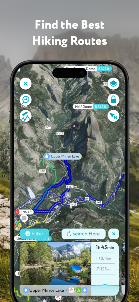
Mobile PeakVisor-App, die 3D-Wanderrouten und Weginformationen für den Half Dome anzeigt
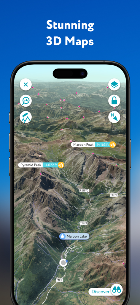
PeakVisor-App mit einer hochpräzisen topografischen 3D-Karte mit beschrifteten Berggipfeln und Wanderwegen
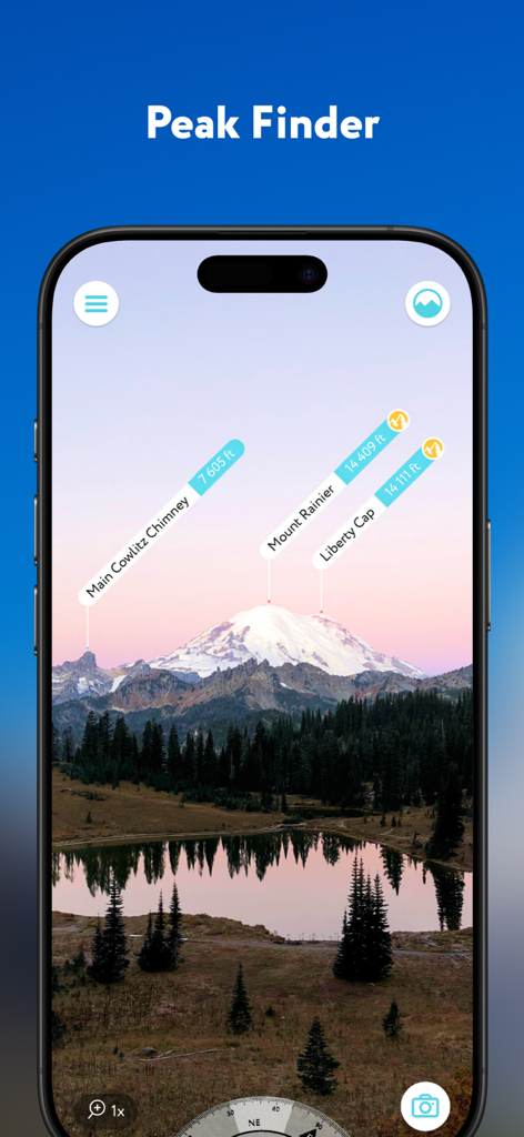
Augmented-Reality-Schnittstelle der PeakVisor-App, die Berggipfel wie den Mount Rainier mit Höhenangaben identifiziert.
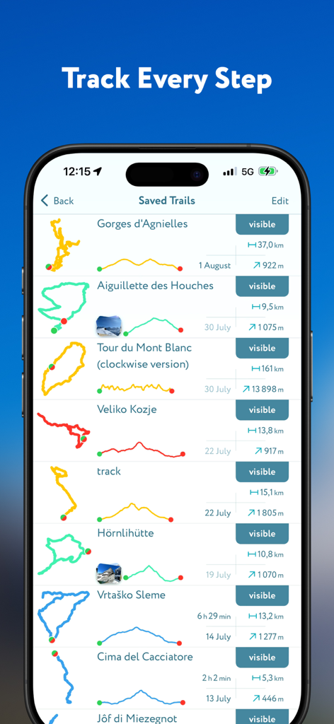
PeakVisor-App-Bildschirm mit einer Liste gespeicherter Wanderwege mit detaillierten Routenkarten und Höhenprofilen
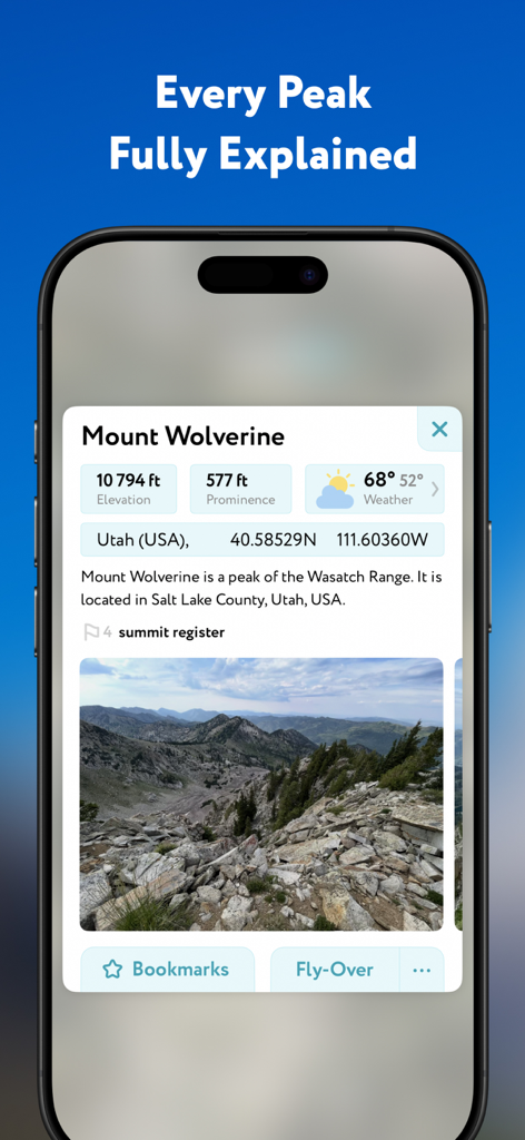
Ein detailliertes Profil des Mount Wolverine in der PeakVisor-App mit Angaben zu Höhe, Prominenz und Wetterdaten.
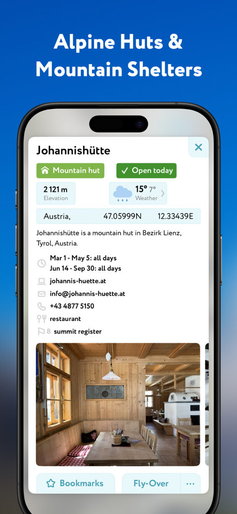
PeakVisor-App-Bildschirm mit Details zur Johannishütte in Österreich mit Höhen- und Wetterinformationen.
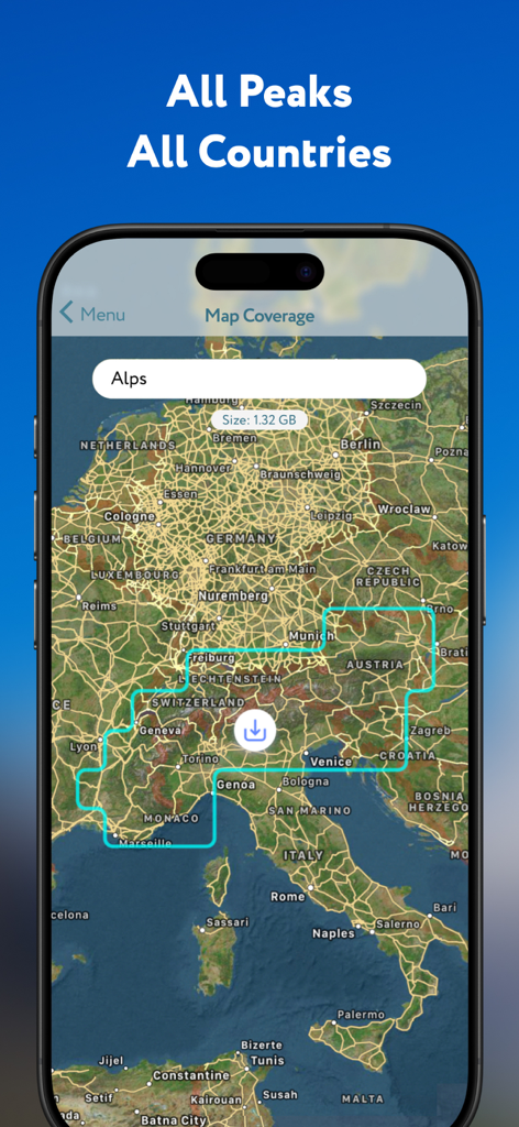
PeakVisor-App-Bildschirm mit einer Karte der Alpen und einer Download-Option für Offline-Bergdaten.
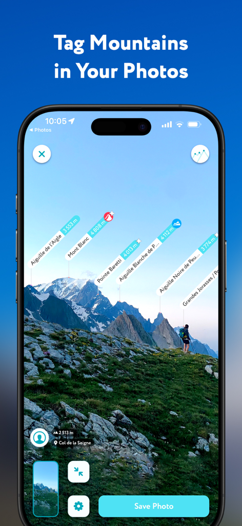
PeakVisor-App-Schnittstelle, die identifizierte Berggipfel mit Namen und Höhenangaben in einem Landschaftsfoto anzeigt.
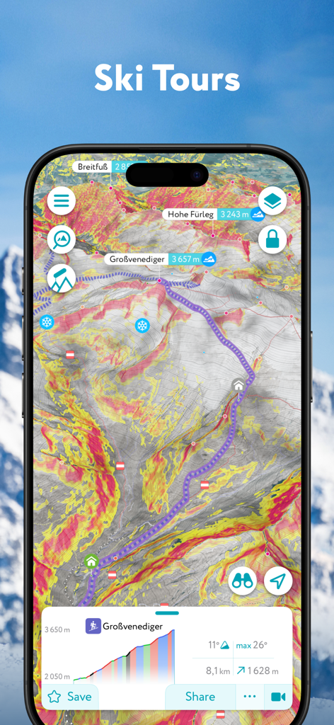
Eine topografische 3D-Karte in der PeakVisor-App, die eine Skitourenroute mit Sicherheits-Overlays zur Hangneigung anzeigt
Beschreibung
Download
Ähnliche Apps
Apps mit ähnlichen Funktionen und Nutzererfahrung


Diese Seite ist keine offizielle Seite der App oder ihres Entwicklers, sondern eine unabhängige redaktionelle Veröffentlichung, die zu Informations- und Kommentarzwecken erstellt wurde. Sofern nicht ausdrücklich anders angegeben, sind weder die App noch ihr Entwickler mit MWM, Apple, Google Play, dem App-Herausgeber oder dem Entwickler der App verbunden, von ihnen unterstützt, gesponsert, autorisiert oder anderweitig offiziell verbunden, und nichts auf dieser Seite impliziert, dass die App unter Verwendung der Dienste von MWM entwickelt wurde. Alle Marken, Logos, Screenshots und andere Inhalte bleiben Eigentum ihrer jeweiligen Inhaber.