Diese Seite ist keine offizielle Seite der App oder ihres Entwicklers, sondern eine unabhängige redaktionelle Veröffentlichung, die zu Informations- und Kommentarzwecken erstellt wurde. Sofern nicht ausdrücklich anders angegeben, sind weder die App noch ihr Entwickler mit MWM, Apple, Google Play, dem App-Herausgeber oder dem Entwickler der App verbunden, von ihnen unterstützt, gesponsert, autorisiert oder anderweitig offiziell verbunden, und nichts auf dieser Seite impliziert, dass die App unter Verwendung der Dienste von MWM entwickelt wurde. Alle Marken, Logos, Screenshots und andere Inhalte bleiben Eigentum ihrer jeweiligen Inhaber.

Trail Explorer
Beherrschen Sie das Gelände mit 3D-Weg-Überflügen, Echtzeit-Wetter-Dashboards und KI-gestützter Erkundung. Entwickelt für den zukunftsorientierten Entdecker, der präzise Planung für Wandern, Klettern und alle Outdoor-Aktivitäten dazwischen verlangt.
Downloads
200Bewertung
Bewertungen gesamt
0Herausgeber
Kategorie
NavigationSprachen
1Neueste Version
2.0.2Größe
67.3 MBErstveröffentlichung
28. Sept. 2022Meistern Sie jedes Gelände
Von 3D-Weg-Vorschauen bis hin zu KI-gestützten Empfehlungen erhalten Sie das ultimative High-Tech-Toolkit zum Wandern, Klettern und Erkunden der Natur.
KI-gestützte Entdeckung
Fragen Sie unsere integrierte KI nach maßgeschneiderten Abenteuerempfehlungen, von hundefreundlichen Wasserfällen bis zur besten Ausrüstung für lokale Gipfel.
Kinematografische Weg-Überflüge
Visualisieren Sie Ihre gesamte Route in 3D, bevor Sie das Haus verlassen, um Höhenprofile und technische Geländeschwierigkeiten zu meistern.
Die folgenden Screenshots und die Beschreibung stammen direkt aus dem offiziellen Store-Eintrag der App und sind Eigentum des Entwicklers.
App Store
Screenshots
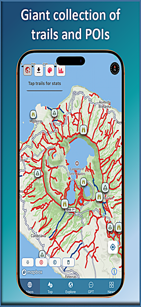
Kartenansicht der Trail Explorer App, die eine riesige Sammlung von Wanderwegen und Sehenswürdigkeiten rund um die Lagunen von Sete Cidades zeigt.
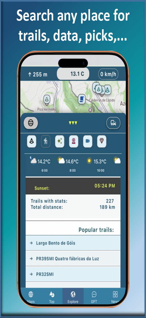
Trail Explorer App-Oberfläche mit Wanderstatistiken, Wettervorhersage und Liste beliebter Wanderwege
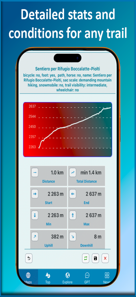
Trail Explorer App-Oberfläche mit einem Höhenprofil-Diagramm und detaillierten Wanderstatistiken
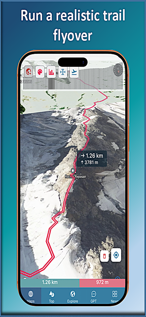
Trail Explorer Mobile App zeigt einen 3D-Luftbild-Überflug eines Bergwanderwegs mit Höhendaten
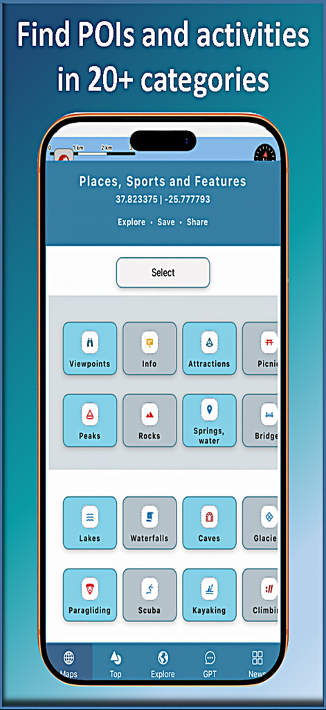
Trail Explorer Mobile App-Oberfläche zeigt mehr als 20 Outdoor-Aktivitäts- und Sehenswürdigkeiten-Kategorien, darunter Wandern, Klettern und Kajakfahren.
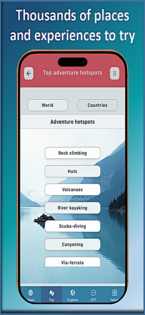
Trail Explorer Mobile App zeigt eine Liste der Top-Abenteuer-Hotspots und Outdoor-Aktivitätskategorien
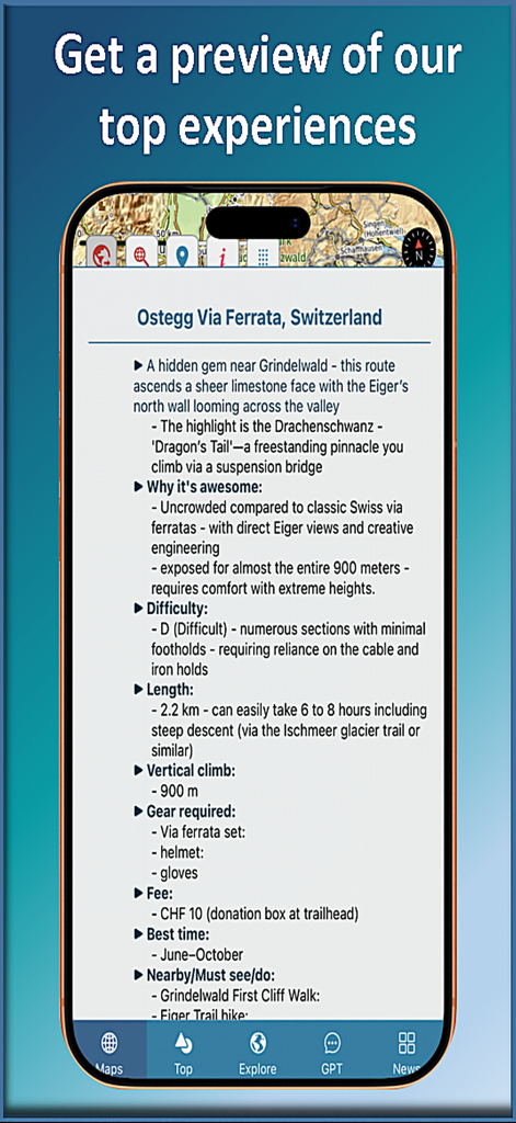
Smartphone-Bildschirm mit Wegdetails wie Schwierigkeitsgrad und Ausrüstungsvoraussetzungen in der Trail Explorer App

Trail Explorer Mobile App zeigt ein Drive-Mode-Dashboard mit Karte, Höhe, Geschwindigkeit und Listen von nahegelegenen Gipfeln und Wasserfällen

Trail Explorer App-Bildschirm zeigt KI-Chat mit lokalen Einblicken und Top-Sehenswürdigkeiten für Hilo Hawaii

Trail Explorer Mobile App Newsfeed mit Artikeln über Yachting und Segeln
Beschreibung
Download
Ähnliche Apps
Top-gerankte Apps in derselben Kategorie

Google Maps
Google LLC

Waze Navigation & Live Traffic
waze

AMap Global
AutoNavi Information Technology Co. Ltd.

百度地图-路线规划,出行必备
Beijing Baidu Netcom Science & Technology Co.,Ltd

Moovit: Bus & Transit Tracker
Moovit App Global LTD

Transit • Subway & Bus Times
9280-0366 Quebec inc.

ParkMobile: Park. Pay. Go.
Parkmobile USA, Inc

腾讯地图-路线规划,导航地铁打车出行
Shenzhen Tencent Computer Systems Company Limited

Île-de-France Mobilités
Ile de France Mobilites
Diese Seite ist keine offizielle Seite der App oder ihres Entwicklers, sondern eine unabhängige redaktionelle Veröffentlichung, die zu Informations- und Kommentarzwecken erstellt wurde. Sofern nicht ausdrücklich anders angegeben, sind weder die App noch ihr Entwickler mit MWM, Apple, Google Play, dem App-Herausgeber oder dem Entwickler der App verbunden, von ihnen unterstützt, gesponsert, autorisiert oder anderweitig offiziell verbunden, und nichts auf dieser Seite impliziert, dass die App unter Verwendung der Dienste von MWM entwickelt wurde. Alle Marken, Logos, Screenshots und andere Inhalte bleiben Eigentum ihrer jeweiligen Inhaber.