Diese Seite ist keine offizielle Seite der App oder ihres Entwicklers, sondern eine unabhängige redaktionelle Veröffentlichung, die zu Informations- und Kommentarzwecken erstellt wurde. Sofern nicht ausdrücklich anders angegeben, sind weder die App noch ihr Entwickler mit MWM, Apple, Google Play, dem App-Herausgeber oder dem Entwickler der App verbunden, von ihnen unterstützt, gesponsert, autorisiert oder anderweitig offiziell verbunden, und nichts auf dieser Seite impliziert, dass die App unter Verwendung der Dienste von MWM entwickelt wurde. Alle Marken, Logos, Screenshots und andere Inhalte bleiben Eigentum ihrer jeweiligen Inhaber.

WingX®
Erhöhen Sie Ihr Situationsbewusstsein mit preisgekrönter synthetischer Sicht, Echtzeit-ADS-B-Wetter und fortschrittlicher Flugplanung. Die vertrauenswürdige Wahl für die Allgemeine Luftfahrt, die erstklassige Leistung und exklusive kostenlose Abonnements für VFR- und Militärpiloten bietet.
Downloads
116K+Bewertung
Bewertungen gesamt
1K+Herausgeber
Kategorie
NavigationSprachen
1Neueste Version
9.2.6.206Größe
80.4 MBErstveröffentlichung
30. Juni 2010Präzisionsnavigation für den professionellen Piloten
Erleben Sie ein funktionsreiches Electronic Flight Bag, das entwickelt wurde, um Sicherheit und Effizienz zu verbessern, von der Vorflugplanung bis zum Endanflug.
Situationsbewusstsein der nächsten Generation
Fliegen Sie mit Zuversicht mit synthetischer Sicht, GPWS-Geländewarnungen und Echtzeit-ADS-B-Verkehrs- und Wetterüberlagerungen auf einer Hochleistungs-Bewegungskarte.
Wert für Militär & VFR-Fokus
Greifen Sie auf branchenführende Luftfahrtwerkzeuge mit speziellen kostenlosen Abonnementstufen für aktives oder pensioniertes Militärpersonal und nur VFR-Piloten zu.
Die folgenden Screenshots und die Beschreibung stammen direkt aus dem offiziellen Store-Eintrag der App und sind Eigentum des Entwicklers.
App Store
Screenshots
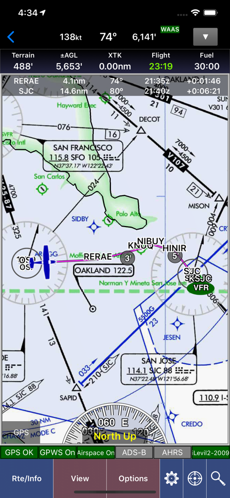
WingX Luftfahrt-Navigationskarte mit Flugdaten und Sektordiagrammen über der Gegend von San Francisco.
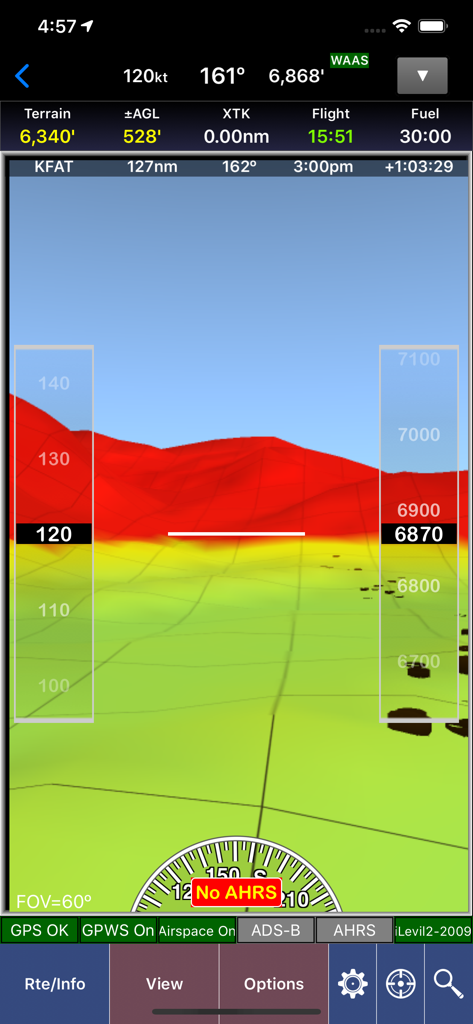
WingX App-Screenshot, der synthetische Sicht mit 3D-Geländekartierung und Fluginstrumenten-Overlays zeigt
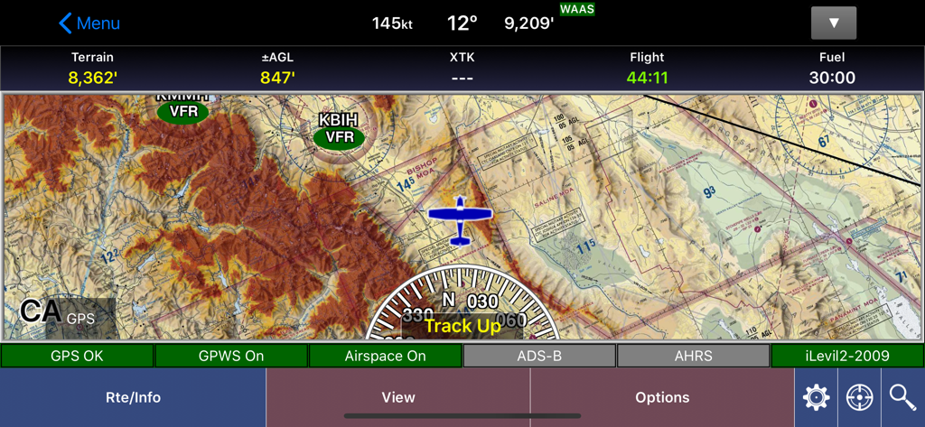
WingX Aviation App bewegliche Kartenoberfläche, die Geländedetails und Flugdaten anzeigt
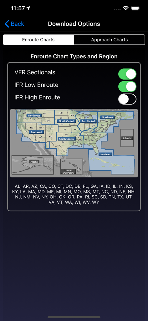
WingX App-Bildschirm für Download-Optionen zum Auswählen von Streckenkarten und US-Regionen
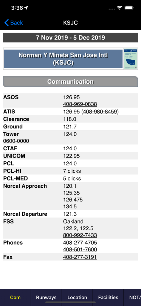
Luftfahrtkommunikationsfrequenzen für den San Jose International Airport in der WingX App
Beschreibung
Download
Ähnliche Apps
Apps mit ähnlichen Funktionen und Nutzererfahrung

Navigraph Charts
Navigraph KB

SkyDemon
Divelements Limited

Airports
Applicate Ltd

OzRunways EFB
OzRunways Pty. Ltd.

fDeck: flight instruments
Darren Yeates

Noisy Goose
Automata Solutions Ltd.

StationWeather - METAR and TAF
Oliver Puetz

Drone UAV Fly Forecast: AirMap
MONIQ TAP COMPANY LIMITED

Airmate
Myriel Aviation SA
Diese Seite ist keine offizielle Seite der App oder ihres Entwicklers, sondern eine unabhängige redaktionelle Veröffentlichung, die zu Informations- und Kommentarzwecken erstellt wurde. Sofern nicht ausdrücklich anders angegeben, sind weder die App noch ihr Entwickler mit MWM, Apple, Google Play, dem App-Herausgeber oder dem Entwickler der App verbunden, von ihnen unterstützt, gesponsert, autorisiert oder anderweitig offiziell verbunden, und nichts auf dieser Seite impliziert, dass die App unter Verwendung der Dienste von MWM entwickelt wurde. Alle Marken, Logos, Screenshots und andere Inhalte bleiben Eigentum ihrer jeweiligen Inhaber.