Diese Seite ist keine offizielle Seite der App oder ihres Entwicklers, sondern eine unabhängige redaktionelle Veröffentlichung, die zu Informations- und Kommentarzwecken erstellt wurde. Sofern nicht ausdrücklich anders angegeben, sind weder die App noch ihr Entwickler mit MWM, Apple, Google Play, dem App-Herausgeber oder dem Entwickler der App verbunden, von ihnen unterstützt, gesponsert, autorisiert oder anderweitig offiziell verbunden, und nichts auf dieser Seite impliziert, dass die App unter Verwendung der Dienste von MWM entwickelt wurde. Alle Marken, Logos, Screenshots und andere Inhalte bleiben Eigentum ihrer jeweiligen Inhaber.

Compass 55. Map & GPS kit.
Meistern Sie jedes Gelände mit hochpräzisen MGRS-Koordinaten, Offline-Karten und technischen Tracking-Tools. Eine robuste, datenschutzorientierte Navigations-Suite für Abenteurer und Profis, die volle Kontrolle und keine Datenweitergabe fordern.
Downloads
987K+Bewertung
Bewertungen gesamt
5K+Herausgeber
Kategorie
NavigationSprachen
7Neueste Version
5.2.3Größe
70.2 MBErstveröffentlichung
23. Sept. 2016Entwickelt für den technischen Abenteurer
Vom Hinterland bis zum Cockpit – Compass 55 liefert professionelle GPS-Tools und absolute Offline-Zuverlässigkeit, ohne Ihren Datenschutz zu gefährden.
Professionelle Präzision
Beherrschen Sie Ihren Standort mit MGRS-, UTM- sowie Breiten- und Längengrad-Koordinaten. Konvertieren, bearbeiten und teilen Sie Wegpunkte mit militärischer Genauigkeit.
Über das Netz hinausgehen
Laden Sie Offline-Karten herunter und importieren Sie benutzerdefinierte Kachelserver. Navigieren Sie in entlegener Wildnis oder auf hoher See, ganz ohne Mobilfunkempfang.
Die folgenden Screenshots und die Beschreibung stammen direkt aus dem offiziellen Store-Eintrag der App und sind Eigentum des Entwicklers.
App Store
Screenshots
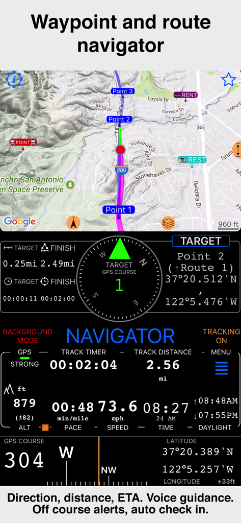
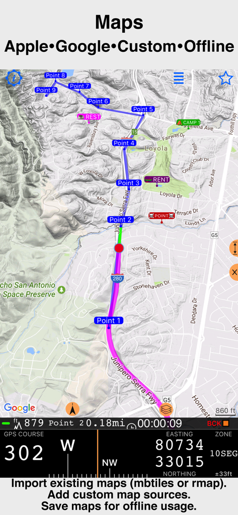
Compass 55-Benutzeroberfläche mit Wegpunkt- und Routennavigation sowie Geschwindigkeits- und Höhendaten
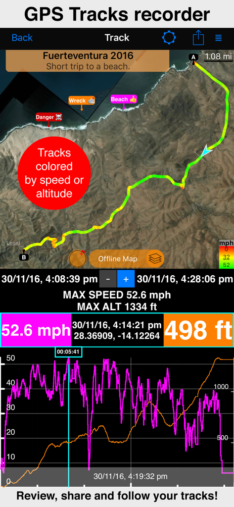
Bildschirm zur GPS-Track-Aufzeichnung mit Geschwindigkeits- und Höhenstatistiken auf der Karte
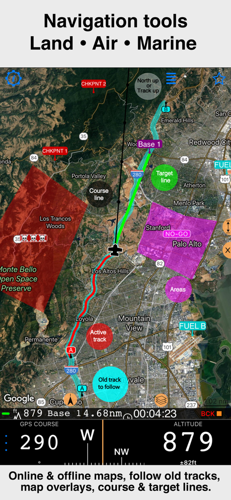
Professionelle Navigations-Benutzeroberfläche von Compass 55 mit Satellitenkarte, Track-Overlays und Höhendaten
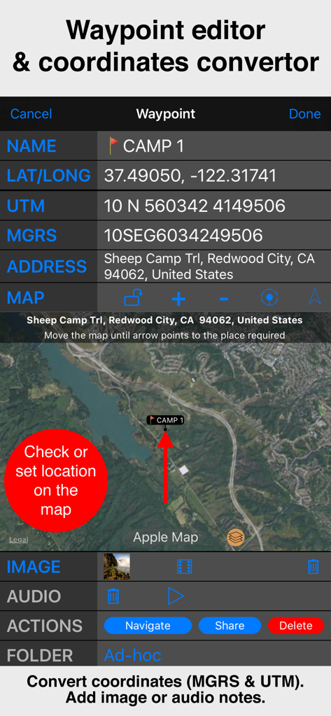
Benutzeroberfläche des Wegpunkt-Editors von Compass 55 mit MGRS- und UTM-Koordinaten sowie einer Satellitenkartenansicht.
Professionelle Navigationskarte von Compass 55 mit technischen GPS-Koordinaten
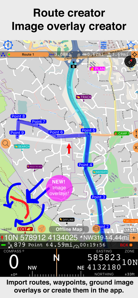
App-Oberfläche von Compass 55 mit Routenerstellung inklusive Wegpunkten und neuer Bild-Overlay-Funktion auf einer topografischen Karte.
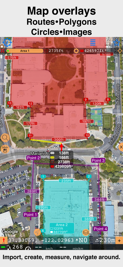
Satellitenkarten-Oberfläche mit benutzerdefinierten Polygonen und Entfernungsmessungen in Compass 55
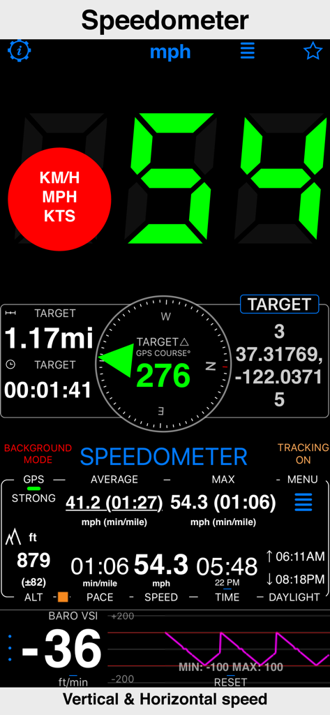
Tachometer-Oberfläche der Compass 55-App mit horizontaler und vertikaler Geschwindigkeit sowie GPS-Daten
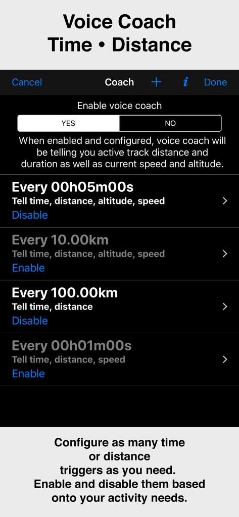
Konfigurationsbildschirm für die Voice-Coach-Funktion in der Compass 55-App mit Zeit- und Distanz-Triggern
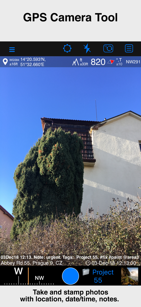
GPS-Kamera-Tool der Compass 55-App mit einem Foto inklusive Standortkoordinaten, Höhe, Datum und Notiz-Overlay
Beschreibung
Download
Ähnliche Apps
Apps mit ähnlichen Funktionen und Nutzererfahrung

MilGPS
Cascode Labs Pty Ltd

SEAiq Pilot VPP
Sakhalin, LLC

Cartograph Maps 3
Harald Meyer

新知卫星地图-路线规划,高清地图导航
Chongqing Xinzhi Space Technology Co., Ltd.

Coordinates – GPS Converter
Mapnitude Company Limited

Mgrs & Utm Map
Vahid Cataltas

DeepStateMap
Heorhii Karpenko

Map Plus
Miocool Inc.

Vetus Maps
Andrey Fetisov
Diese Seite ist keine offizielle Seite der App oder ihres Entwicklers, sondern eine unabhängige redaktionelle Veröffentlichung, die zu Informations- und Kommentarzwecken erstellt wurde. Sofern nicht ausdrücklich anders angegeben, sind weder die App noch ihr Entwickler mit MWM, Apple, Google Play, dem App-Herausgeber oder dem Entwickler der App verbunden, von ihnen unterstützt, gesponsert, autorisiert oder anderweitig offiziell verbunden, und nichts auf dieser Seite impliziert, dass die App unter Verwendung der Dienste von MWM entwickelt wurde. Alle Marken, Logos, Screenshots und andere Inhalte bleiben Eigentum ihrer jeweiligen Inhaber.