Diese Seite ist keine offizielle Seite der App oder ihres Entwicklers, sondern eine unabhängige redaktionelle Veröffentlichung, die zu Informations- und Kommentarzwecken erstellt wurde. Sofern nicht ausdrücklich anders angegeben, sind weder die App noch ihr Entwickler mit MWM, Apple, Google Play, dem App-Herausgeber oder dem Entwickler der App verbunden, von ihnen unterstützt, gesponsert, autorisiert oder anderweitig offiziell verbunden, und nichts auf dieser Seite impliziert, dass die App unter Verwendung der Dienste von MWM entwickelt wurde. Alle Marken, Logos, Screenshots und andere Inhalte bleiben Eigentum ihrer jeweiligen Inhaber.

onX Backcountry: Trail GPS App
Nie wieder verirren. Diese App verwandelt Ihr Smartphone in einen Präzisions-GPS-Navigator für jede Wildnis.
Downloads
1M+Bewertung
Bewertungen gesamt
5.7KHerausgeber
Kategorie
NavigationSprachen
1Neueste Version
26.13.0Größe
433.2 MBErstveröffentlichung
9. Dez. 2020Eine detaillierte Einschätzung der 'onX Backcountry: Trail GPS App' für erfahrene Outdoor-Enthusiasten.
Analytische Bewertung der Kernfunktionen
Offline-Karten & GPS-Tracking
Die App ermöglicht das Herunterladen detaillierter 3D-Karten für die Offline-Nutzung und bietet präzises GPS-Tracking, was eine zuverlässige Navigation auch ohne Mobilfunkempfang in abgelegenen Gebieten sicherstellt.
Erweiterte Terrainanalyse & Sicherheit
Dieses Tool verfügt über LiDAR-basierte topografische Karten, Funktionen zur Analyse von Hangneigung und -exposition sowie Informationen zur Lawinengefahrenskala (ATES), wodurch Nutzer das Gelände präzise einschätzen und potenzielle Gefahren minimieren können.
Flexible Kartenmodi & Gefahrenlayer
Es bietet spezialisierte Kartenmodi für Wandern, Mountainbiken und Skitouren sowie anpassbare Layer, die Informationen zu Gefahren wie Waldbränden oder Lawinenterrain anzeigen, um eine angepasste und sichere Routenplanung zu ermöglichen.
Echtzeit-Wetter & Umgebungsdaten
Die App liefert lokalisierte Wetter- und Windvorhersagen sowie aktuelle Satellitenbilder. Dies ermöglicht Nutzern, ihre Pläne basierend auf den neuesten Bedingungen anzupassen und Risiken zu minimieren.
Umfassende Routendatenbank
Dieses Tool verfügt über eine riesige Datenbank mit über 650.000 Meilen an Wander- und Mountainbike-Wegen, 300.000 Kletterrouten und 4.000 Skitouren, was die Entdeckung und Planung neuer Abenteuer erheblich vereinfacht.
Intuitive 3D-Routenplanung
Es ermöglicht Nutzern, individuelle Routen nahtlos mit einer "Snap-to-Trail"-Funktion zu erstellen, Wegpunkte hinzuzufügen und die gesamte Tour in 3D zu visualisieren, was das Verständnis des Geländes vorab verbessert.
Detaillierte Routeninformationen
Die App bietet detaillierte Informationen zu Wegschwierigkeit, Distanz und Höhenmetern für empfohlene und selbst erstellte Routen, wodurch Nutzer fundierte Entscheidungen treffen und ihre Touren optimal anpassen können.
Warnungen vor Privatland (Elite)
Die App beinhaltet einen Layer für Privatland (nur Elite), der Grundstücksgrenzen und Eigentumsverhältnisse anzeigt. Es hilft Nutzern, verantwortungsbewusst zu handeln und unbeabsichtigtes Betreten von Privateigentum zu vermeiden.
Häufig gestellte Fragen
Alles, was Sie über wissen müssen onX Backcountry: Trail GPS App
What is onX Backcountry used for?
onX Backcountry is a GPS map app for outdoor recreation, enabling users to discover and navigate new trails for hiking, skiing, mountain biking, and climbing, even offline.
Does onX Backcountry offer offline navigation?
Yes, onX Backcountry allows users to download 3D maps with interactive trail data for offline use. This turns a phone into a handheld GPS device without cell service.
Can I create custom routes in onX Backcountry?
Yes, onX Backcountry allows users to map custom routes seamlessly with its snap-to-trail feature. Users can also set Waypoints and review detailed slope data for planning.
What types of maps does onX Backcountry provide?
onX Backcountry provides 3D maps, HD topographic maps, satellite imagery, and hybrid views. Users can also select map modes specific to hiking, MTB, climbing, or ski touring.
What safety features are included in onX Backcountry?
onX Backcountry includes safety tools like localized weather forecasts, hourly wind data, and Trail Reports. It also features map layers to monitor wildfire, air quality, and avalanche terrain exposure.
Is there a free trial for onX Backcountry?
Yes, onX Backcountry offers a free seven-day Premium trial upon app installation. This trial provides access to all the app's advanced features for a complete backcountry experience.
What are the exclusive features for onX Backcountry Elite members?
onX Backcountry Elite membership exclusively includes the Private Land Layer, which shows property maps and boundaries, and Recent Imagery, providing detailed satellite views from the past two weeks.
Can onX Backcountry track my outdoor activity statistics?
Yes, onX Backcountry allows users to track their location and measure activity stats. It displays key trip details such as distance, elevation gain, and elevation loss in seconds.
Where can I find the privacy policy for onX Backcountry?
The official privacy policy for onX Backcountry is available on the onXmaps website. You can find the detailed policy at https://www.onxmaps.com/privacy-policy.
Does onX Backcountry provide detailed trail information?
Yes, onX Backcountry offers a "Guidebook Experience" with detailed trail descriptions. This includes trail lengths, difficulty levels, elevation profiles, and user reviews for various routes.
Die folgenden Screenshots und die Beschreibung stammen direkt aus dem offiziellen Store-Eintrag der App und sind Eigentum des Entwicklers.
App Store
Screenshots
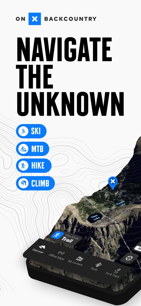
Die App präsentiert verschiedene Outdoor-Aktivitäten wie Wandern und Skifahren, die Nutzer über dedizierte Buttons auswählen können, um ihre Abenteuer zu planen.
Aktivitäten mühelos wählen
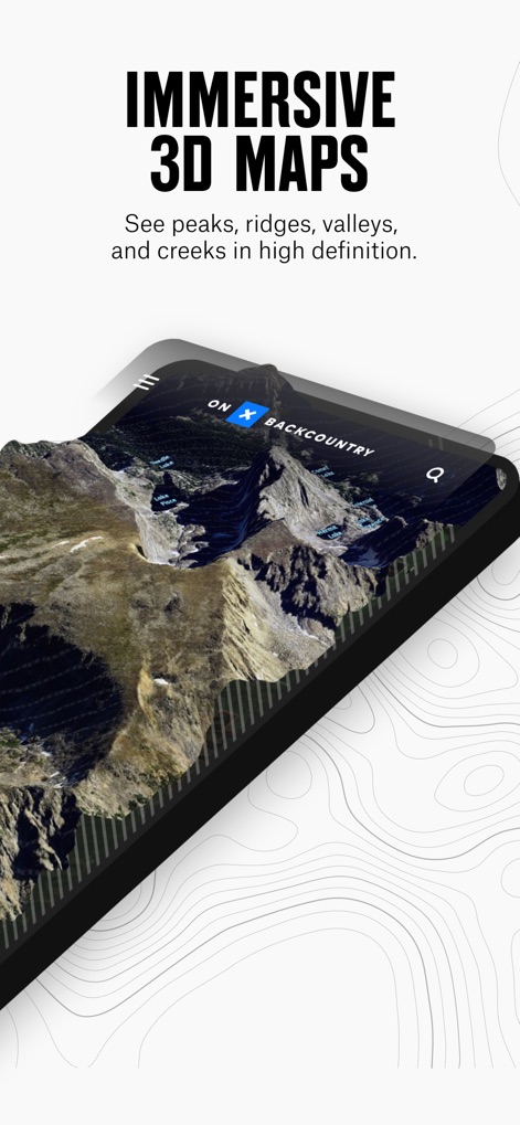
Nutzer erleben detaillierte Geländeformen mit dieser dreidimensionalen Karte, die Gipfel und Seen in hoher Auflösung darstellt und eine realistische Ansicht bietet.
Immersive 3D-Karten
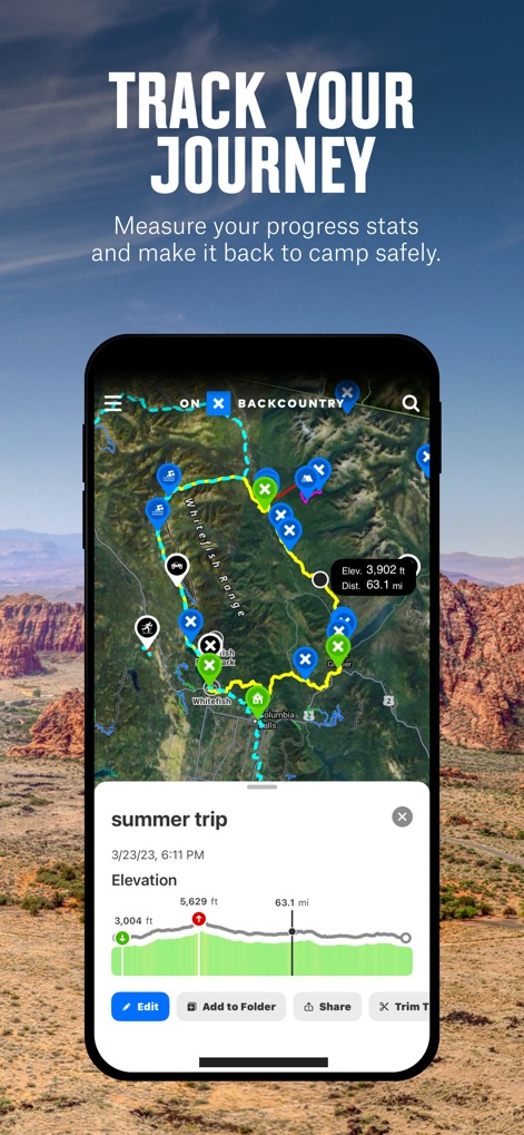
Die App ermöglicht die Aufzeichnung von Routen, wobei eine detaillierte Karte den zurückgelegten Pfad und ein interaktives Höhendiagramm die vertikalen Veränderungen zeigt.
Reisen nachverfolgen
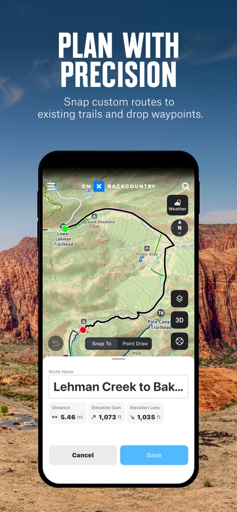
Dieses Tool unterstützt die Erstellung individueller Routen mit einer präzisen Anzeige von Distanz und Höhengewinn, ergänzt durch die Möglichkeit, Wegpunkte zu setzen.
Routen präzise planen
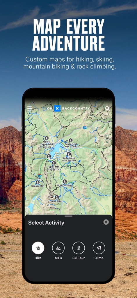
Die Anwendung bietet eine breite Palette an Outdoor-Aktivitäten, dargestellt durch wählbare Icons für Wandern und Mountainbiken, um passende Routen zu finden.
Jedes Abenteuer kartieren
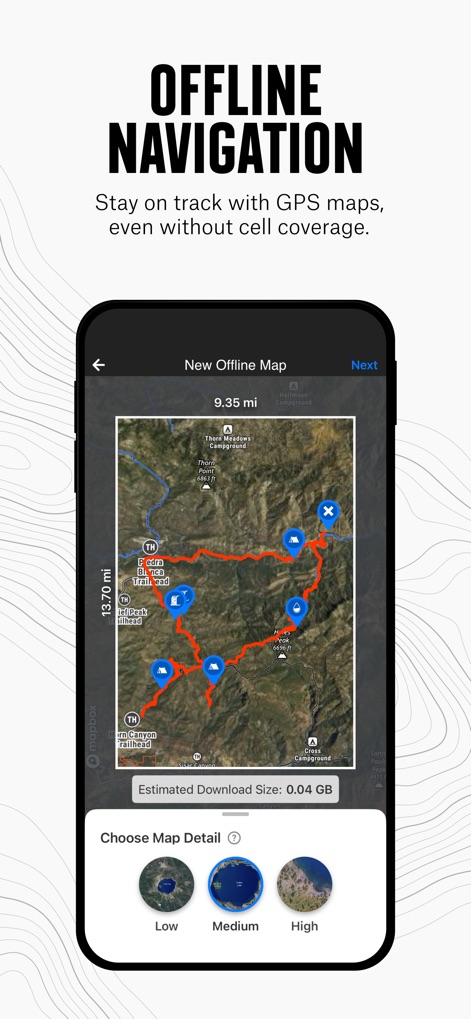
Nutzer können Kartenbereiche für die Offline-Nutzung herunterladen und dabei den Detailgrad auswählen, um auch ohne Mobilfunkempfang den vorgezeichneten Routen zu folgen.
Offline navigieren
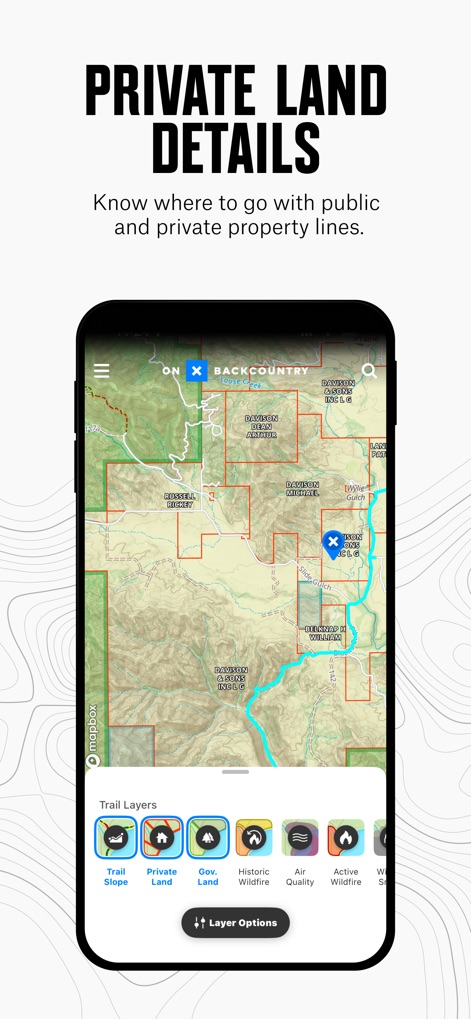
Dieses Tool visualisiert private Landgrenzen und bietet verschiedene Kartenebenen wie 'Private Land' und 'Gov Land', um die Orientierung im Gelände zu erleichtern.
Private Landinformationen
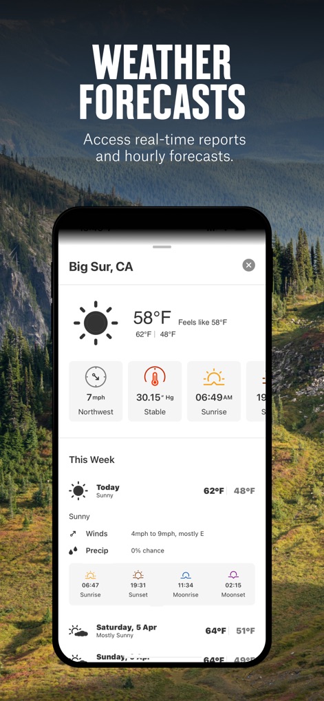
Die App liefert umfassende Wettervorhersagen, einschließlich aktueller Temperaturangaben und stündlicher Windprognosen, um Outdoor-Aktivitäten sicher zu planen.
Wetterdaten abrufen
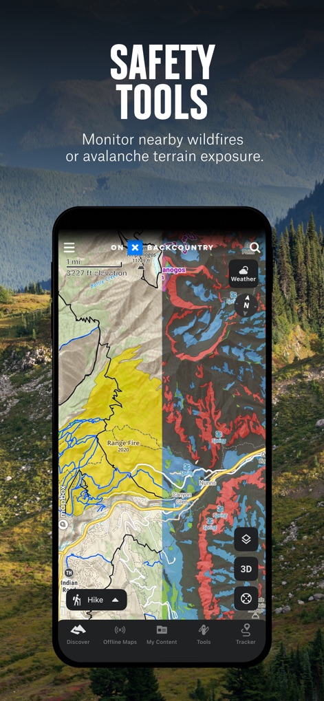
Nutzer profitieren von fortschrittlichen Sicherheitsfunktionen, die potenzielle Gefahren wie Wildfeuergebiete und Lawinengelände auf der Karte hervorheben.
Sicherheits-Werkzeuge

Die App bietet detaillierte Routenbeschreibungen, die wichtige Informationen wie Distanz und Höhengewinn sowie visuelle Bewertungen der Strecke beinhalten.
Digitaler Tourenführer
Beschreibung
Download
Ähnliche Apps
Apps mit ähnlichen Funktionen und Nutzererfahrung

AllTrails: Hike, Bike & Run
AllTrails, Inc.

Pedometer++
Cross Forward Consulting, LLC

Organic Maps: Offline Map
Organic Maps OU

Gaia GPS: Mobile Trail Maps
Trailbehind, INC.

Offline hiking maps: Mapy.com
Seznam.cz a.s.

Hiking Map Poland
Mapa Turystyczna sp. z o.o.

MapOut
Valnova GmbH

FarOut: Offline GPS Trail Maps
Atlas Guides DE, Inc.

Norgeskart
Norgeskart AS
Diese Seite ist keine offizielle Seite der App oder ihres Entwicklers, sondern eine unabhängige redaktionelle Veröffentlichung, die zu Informations- und Kommentarzwecken erstellt wurde. Sofern nicht ausdrücklich anders angegeben, sind weder die App noch ihr Entwickler mit MWM, Apple, Google Play, dem App-Herausgeber oder dem Entwickler der App verbunden, von ihnen unterstützt, gesponsert, autorisiert oder anderweitig offiziell verbunden, und nichts auf dieser Seite impliziert, dass die App unter Verwendung der Dienste von MWM entwickelt wurde. Alle Marken, Logos, Screenshots und andere Inhalte bleiben Eigentum ihrer jeweiligen Inhaber.