Diese Seite ist keine offizielle Seite der App oder ihres Entwicklers, sondern eine unabhängige redaktionelle Veröffentlichung, die zu Informations- und Kommentarzwecken erstellt wurde. Sofern nicht ausdrücklich anders angegeben, sind weder die App noch ihr Entwickler mit MWM, Apple, Google Play, dem App-Herausgeber oder dem Entwickler der App verbunden, von ihnen unterstützt, gesponsert, autorisiert oder anderweitig offiziell verbunden, und nichts auf dieser Seite impliziert, dass die App unter Verwendung der Dienste von MWM entwickelt wurde. Alle Marken, Logos, Screenshots und andere Inhalte bleiben Eigentum ihrer jeweiligen Inhaber.

OpenSeaMap
Greifen Sie auf weltweit kostenlose maritime Daten, Hafeninformationen und Wetter-Layer zu. Navigieren Sie Ihr nächstes Küstenabenteuer mit leistungsstarken Offline-Karten, die für die Freizeitbootfahrt-Community entwickelt wurden.
Downloads
222K+Bewertung
Bewertungen gesamt
300Herausgeber
Kategorie
NavigationSprachen
3Neueste Version
4.2Größe
13.2 MBErstveröffentlichung
25. Jan. 2012Smartere nautische Navigation ohne Abonnement
Treten Sie der globalen Open-Source-Community bei und greifen Sie auf kostenlose, detaillierte Seekarten zu, die für sekundäre Steuerbord-Displays und die Küstenexploration entwickelt wurden.
Vollständige Offline-Zuverlässigkeit
Speichern Sie bis zu 1 Million Kartenkacheln auf Ihrem Gerät, damit Sie auch dann navigieren können, wenn Funksignale Meilen vor der Küste versagen.
Kostenlose nautische Intelligenz
Verzichten Sie auf teure Jahresgebühren mit einer weltweiten Karte, die Wetterdaten und Hafeninformationen aus dem OpenStreetMap-Projekt enthält.
Die folgenden Screenshots und die Beschreibung stammen direkt aus dem offiziellen Store-Eintrag der App und sind Eigentum des Entwicklers.
App Store
Screenshots
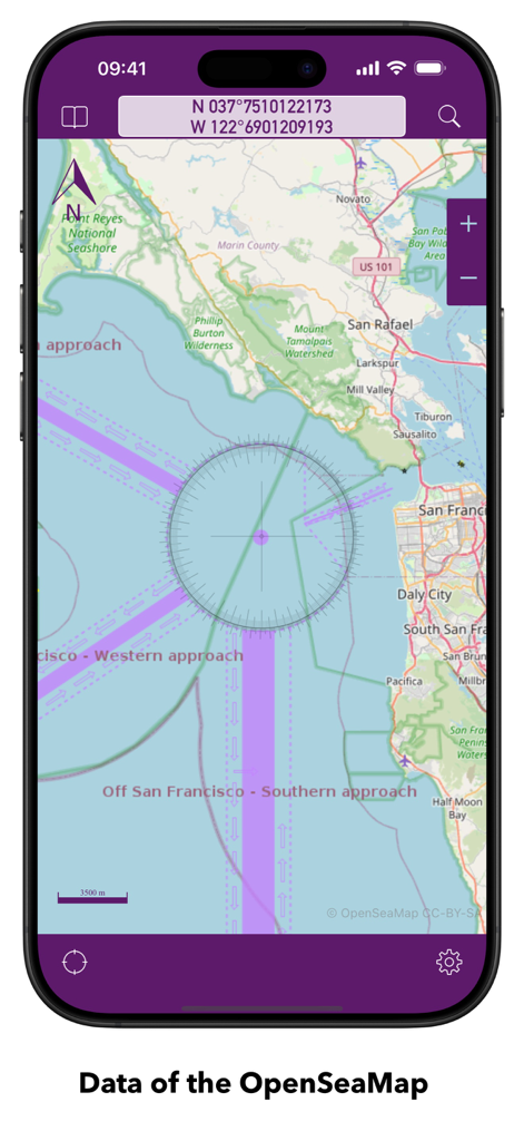
OpenSeaMap-App zeigt eine Seekarte der San Francisco Bay mit Koordinaten und Navigationsmarkierungen
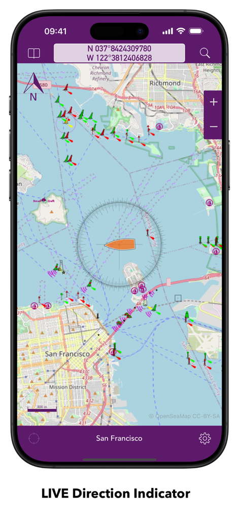
OpenSeaMap-App zeigt eine Seekarte von San Francisco mit einem Live-Richtungsanzeiger und maritimen Navigationsmarkierungen
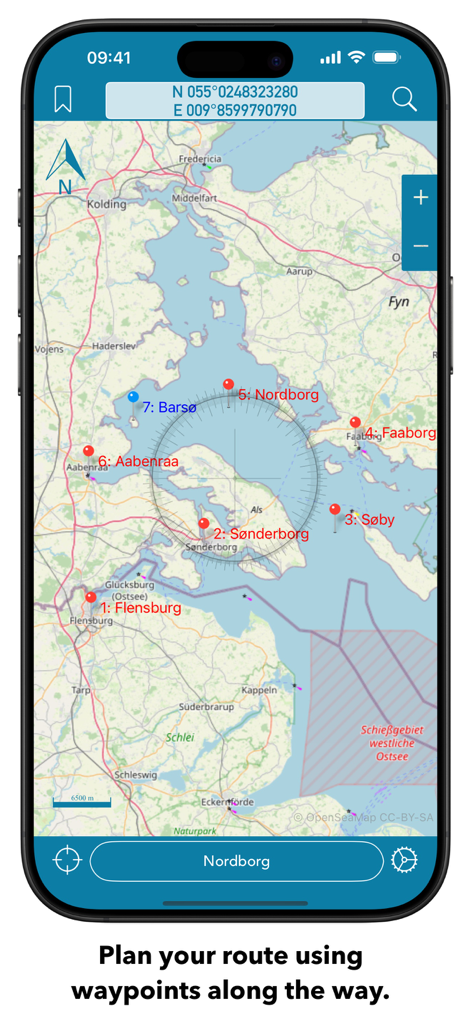
OpenSeaMap-Seekartenoberfläche auf einem Smartphone, die Routenplanung mit mehreren Wegpunkten und einer Kompass-Überlagerung zeigt.
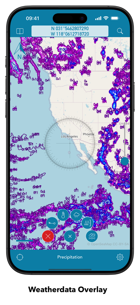
OpenSeaMap Mobile-Oberfläche zeigt eine Niederschlagswetterdaten-Überlagerung auf einer Seekarte
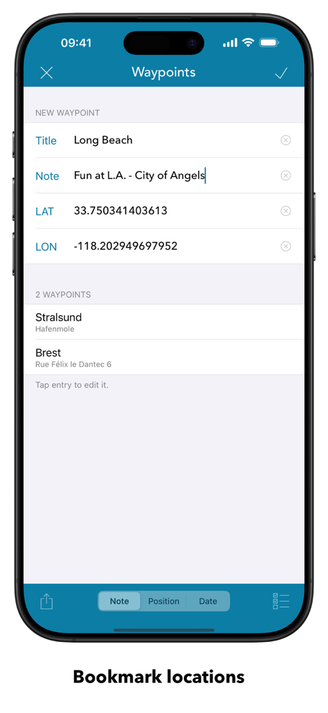
OpenSeaMap Mobile-App-Bildschirm für Wegpunkte, der markierte nautische Orte und die Eingabe von Koordinaten zeigt
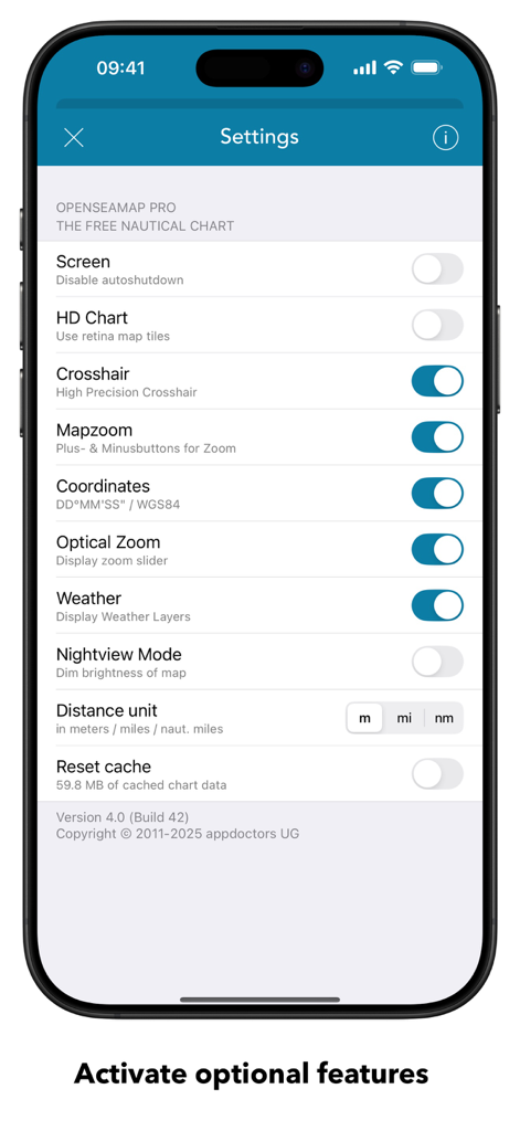
OpenSeaMap-Einstellungsbildschirm mit Optionen zur Konfiguration von Seekarten und Navigation
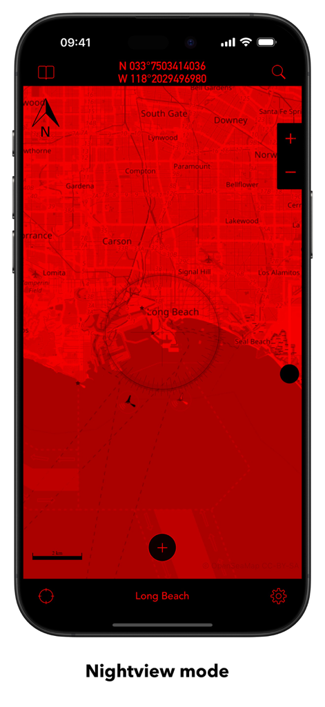
OpenSeaMap Mobile-App-Oberfläche zeigt eine rote Nachtansichtskarte von Long Beach
Beschreibung
Download
Ähnliche Apps
Apps mit ähnlichen Funktionen und Nutzererfahrung

PredictWind — Marine Forecasts
PredictWind Limited

Navily
The Navigation Family

Argo - Boating Navigation
Argo Navigation, LLC

SEAiq Pilot
Sakhalin, LLC

Maptrails
Pasi Salenius

KartenWerft NavGo 2.0
KartenWerft GmbH

MarineTraffic - Ship Tracking
MARINETRAFFIC APPLICATIONS LTD

Wavve Boating: Marine Boat GPS
Wavve Boating Inc

Savvy Navvy Boating Navigation
SAVVY NAVVY LTD
Diese Seite ist keine offizielle Seite der App oder ihres Entwicklers, sondern eine unabhängige redaktionelle Veröffentlichung, die zu Informations- und Kommentarzwecken erstellt wurde. Sofern nicht ausdrücklich anders angegeben, sind weder die App noch ihr Entwickler mit MWM, Apple, Google Play, dem App-Herausgeber oder dem Entwickler der App verbunden, von ihnen unterstützt, gesponsert, autorisiert oder anderweitig offiziell verbunden, und nichts auf dieser Seite impliziert, dass die App unter Verwendung der Dienste von MWM entwickelt wurde. Alle Marken, Logos, Screenshots und andere Inhalte bleiben Eigentum ihrer jeweiligen Inhaber.