このページはアプリまたはその開発者の公式ページではなく、情報提供および論評を目的として作成された独立した編集出版物です。明示的に別段の記載がない限り、アプリおよびその開発者は、MWM、Apple、Google Play、アプリのパブリッシャー、またはアプリの開発者と提携、承認、後援、認可、またはその他の公式的な関係はなく、このページのいかなる内容も、アプリがMWMのサービスを使用して開発されたことを意味するものではありません。すべての商標、ロゴ、スクリーンショット、その他のコンテンツはそれぞれの所有者の財産です。

AirNav Radar – Flight Tracker
空の支配者として、地球上のあらゆる航空機をリアルタイムで追跡。このアプリは、ユーザーにフライトの全貌を明かします。
ダウンロード
1M+ユーザー評価
評価数
4.1K開発元
カテゴリ
Travel対応言語
1最新バージョン
3.3.2サイズ
106.6 MBリリース日
2018年7月28日主要機能の包括的分析
AirNav Radar – Flight Tracker: テックアナリストの評価
リアルタイム飛行追跡と通知
このアプリは、フライトの現在位置をリアルタイムで追跡し、ステータスの変更があれば即座に通知を送信します。これにより、ユーザーはフライトの状況を常に把握できます。
グローバルなマルチソースデータ統合
本ツールは、ADS-B、MLAT、衛星、および海洋データを含む複数のソースからの情報を統合することで、地球上のあらゆる場所の航空機に対し、非常に高精度で信頼性の高い追跡データを提供します。
インタラクティブなレーダー地図と緊急機表示
ユーザーは、最も追跡されているフライトや緊急事態の航空機をインタラクティブなレーダー地図上で視覚的に確認できます。
詳細な航空機・フライト情報
このアプリケーションは、ライブの現在位置、ルート、航空機の写真だけでなく、航空機の製造元、モデル、航空会社、高度、速度などの詳細情報を提供します。
空港の到着・出発状況モニタリング
ユーザーは、任意の空港における到着便と出発便の状況を明確に監視でき、旅行計画や出迎えに役立ちます。
過去のフライト履歴とリプレイ
本サービスは、過去のフライトデータを7日間まで(プレミアムプランでは最大365日)再生・確認する機能を提供し、過去のルートやパフォーマンスの分析を可能にします。
ライブ管制塔無線アクセス
この機能により、ユーザーは主要な空港の管制塔からのライブ無線交信を無制限に聞くことができ(プレミアム機能)、航空愛好家やプロフェッショナルにとって貴重な洞察を提供します。
高度な飛行グラフと分析
本プラットフォームは、時間経過に伴う高度や速度の変動を示す詳細なフライトグラフを提供し(プレミアム機能)、より深い分析をサポートします。
気象レイヤーと専門地図
ユーザーは、航空機の飛行ルートや空港周辺の気象状況を視覚化するために、様々な気象レイヤーや地形、衛星、航空地図レイヤーを利用できます(プレミアム機能)。
高度なフィルタリング機能
このツールは、フライトや航空機を高度にフィルタリングする機能を提供し(プレミアム機能)、ユーザーが特定の基準に基づいて情報を迅速に絞り込むことを可能にします。
よくある質問
について知っておくべきこと AirNav Radar – Flight Tracker
What is AirNav Radar – Flight Tracker?
AirNav Radar is a real-time flight tracker app providing accurate, live aircraft and flight tracking worldwide. It is used by aviation enthusiasts, travelers, pilots, and professionals to track planes from takeoff to landing.
How accurate is AirNav Radar's flight tracking?
AirNav Radar delivers high-precision real-time flight data. It combines data from a global network of over 36,000 receivers, ADS-B, MLAT, satellite, and oceanic sources, making it one of the most accurate trackers.
Does AirNav Radar track flights globally?
Yes, AirNav Radar provides comprehensive global flight coverage. Its network of over 36,000 receivers covers major airports and international flight corridors worldwide, tracking flights over land and remote regions.
What real-time information does AirNav Radar provide for flights?
AirNav Radar provides live flight position, route, aircraft photos, make, model, airline, altitude, and speed. It also offers real-time notifications for flight status changes and arrival/departure monitoring.
Can I replay past flights using AirNav Radar?
Yes, AirNav Radar allows users to replay past flights. The free version offers up to 7 days of historical data, while the Ads-Free plan extends this to 30 days, and the Business Plan to 365 days.
What technology does AirNav Radar use to track aircraft?
AirNav Radar uses a multi-source tracking approach. It combines data from ADS-B transponders, MLAT, ASDI, oceanic data, and satellite, leveraging a global network of over 36,000 receivers.
What are the benefits of the AirNav Radar Ads-Free Plan?
The Ads-Free Plan provides a completely ads-free experience, unlimited access to live airport control tower radio, full flight graphs showing altitude and speed, and access to 30 days of historical flight data and replays.
What advanced features are in the AirNav Radar Pilot Plan?
The Pilot Plan includes all Ads-Free features plus advanced aviation tools. These include terrain, satellite, and aviation map layers, weather layers for airports and routes, and advanced flight and aircraft filtering.
Does AirNav Radar offer a plan for professional use?
Yes, AirNav Radar offers a Business Plan. This plan includes professional-grade tools like up to 365 days of historical data, fleet tracking for multiple aircraft, detailed airport overviews, and expanded raw flight data downloads.
Can AirNav Radar display real-time weather conditions?
Yes, the AirNav Radar Pilot Plan includes weather layers, providing real-time weather conditions for airports and full flight routes. These overlays include cloud coverage, precipitation, and wind barbs.
Does AirNav Radar have an augmented reality feature?
Yes, AirNav Radar includes an Augmented Reality feature. Users can point their camera to the sky to instantly identify planes above them and view their flight details in real-time.
Can AirNav Radar show detailed information about an aircraft?
Yes, AirNav Radar provides detailed aircraft information. This includes the aircraft's make, model, airline, registration, serial number, age, and even seat map configuration.
Does AirNav Radar show live airport departure and arrival boards?
Yes, AirNav Radar features Live Flight Boards. Users can monitor arrivals and departures at any airport worldwide, viewing clear flight status updates for each flight.
以下のスクリーンショットと説明は、アプリの公式ストアリスティングから直接取得されたものであり、アプリ開発者の所有物です。
アプリストア
スクリーンショット
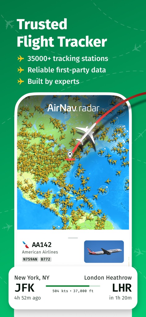
世界中の35,000以上のトラッキングステーションからのデータにより、詳細なフライト情報と信頼性の高い航空機位置を表示します。
信頼のフライト追跡
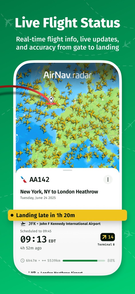
ニューヨークからロンドンまでのフライトAA142の詳細な運航状況と、到着遅延情報や予定時刻を確認できます。
リアルタイム運航状況
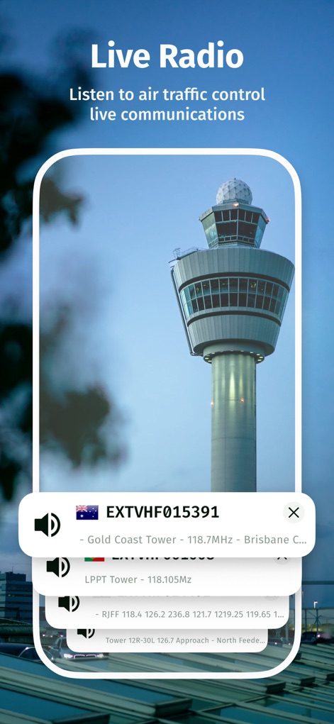
航空交通管制のライブ通信を聞き、ゴールドコーストタワーやLPPTタワーなどの無線周波数にアクセスできます。
ライブ無線通信

エミレーツ航空のA380-861の登録番号や機体年齢、さらにエコノミーとビジネスの座席構成を確認できます。
機体詳細情報
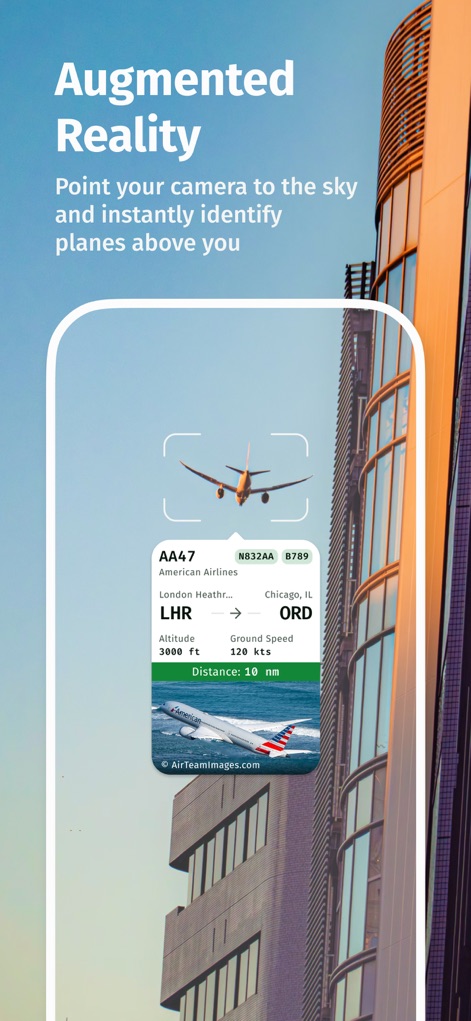
カメラを空に向けることで、上空の航空機AA47の高度と速度、さらには出発地と目的地を瞬時に識別します。
拡張現実で識別

様々な航空会社や機体の美しい写真を通じて、多様なフライトの世界を探索できます。
魅力的な航空機を発見
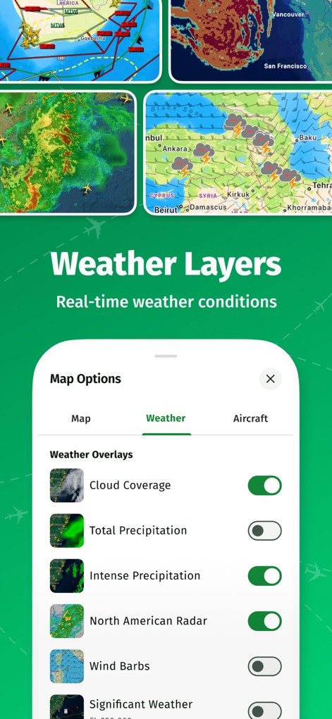
雲量や降水量、さらには風向風速などの様々な気象オーバーレイを地図上で選択し表示できます。
気象情報レイヤー
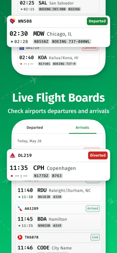
空港の発着便リストを表示し、DL219の運航変更状況やTHY6070のライブステータスを確認できます。
ライブ発着案内板

サム・チューイや航空管制官からの高評価のコメントと、ニューヨーク・タイムズなどの著名メディアでの紹介を確認できます。
信頼の声
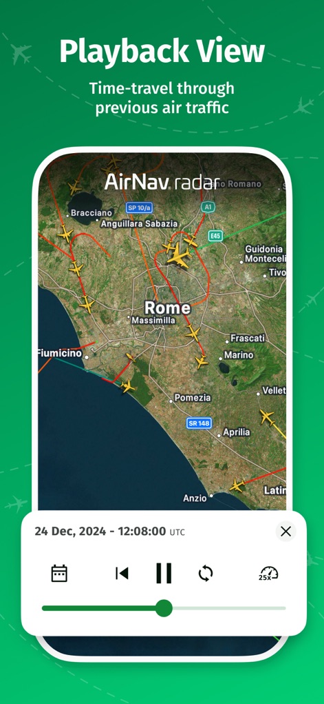
ローマ周辺の過去のフライト経路を地図上で再生し、特定の日時の航空交通状況を確認できます。
フライト履歴再生
説明
Download
類似アプリ
似た機能とユーザー体験を持つアプリ

Flightradar24 | Flight Tracker
Flightradar24 AB

飞常准-航班动态机票购买查询追踪值机
FEEYO.COM E-COMMERCE CORP.

Flighty – Live Flight Tracker
Flighty LLC

Flight Tracker: Plane Radar 24
Oleksandr Vynnyk

FlightStats
LNRS Data Services Limited

AirHelp・Flight Tracker
AirHelp Germany GmbH

Spot the Station
NASA

Flight Tracker & Radar
ISLAND STORM LABS LIMITED

Flight Tracker - Plane Status
Discover Ukraine LLC
このページはアプリまたはその開発者の公式ページではなく、情報提供および論評を目的として作成された独立した編集出版物です。明示的に別段の記載がない限り、アプリおよびその開発者は、MWM、Apple、Google Play、アプリのパブリッシャー、またはアプリの開発者と提携、承認、後援、認可、またはその他の公式的な関係はなく、このページのいかなる内容も、アプリがMWMのサービスを使用して開発されたことを意味するものではありません。すべての商標、ロゴ、スクリーンショット、その他のコンテンツはそれぞれの所有者の財産です。