このページはアプリまたはその開発者の公式ページではなく、情報提供および論評を目的として作成された独立した編集出版物です。明示的に別段の記載がない限り、アプリおよびその開発者は、MWM、Apple、Google Play、アプリのパブリッシャー、またはアプリの開発者と提携、承認、後援、認可、またはその他の公式的な関係はなく、このページのいかなる内容も、アプリがMWMのサービスを使用して開発されたことを意味するものではありません。すべての商標、ロゴ、スクリーンショット、その他のコンテンツはそれぞれの所有者の財産です。

ダウンロード
79K+ユーザー評価
評価数
0開発元
カテゴリ
Travel対応言語
9最新バージョン
1.4サイズ
41.7 MBリリース日
2014年10月12日アルプスの地平線をマスターする
地元の人のような自信を持ってヨーロッパアルプスをナビゲートしましょう。私たちの拡張現実技術は、国際的な探検家の知識のギャップを埋め、すべての景色をデータリッチな体験に変えます。
瞬時の山頂インテリジェンス
7カ国にわたる20,000以上の山頂を瞬時に特定。カメラを向けるだけで、リアルタイムで風景に重ねて表示される名前、標高、距離を確認できます。
100%オフライン信頼性
高額な国際ローミング料金とデータデッドゾーンを排除。すべての山頂、地図、関心のある場所はローカルに保存されており、トレイルでの完全な独立性を実現します。
以下のスクリーンショットと説明は、アプリの公式ストアリスティングから直接取得されたものであり、アプリ開発者の所有物です。
アプリストア
スクリーンショット
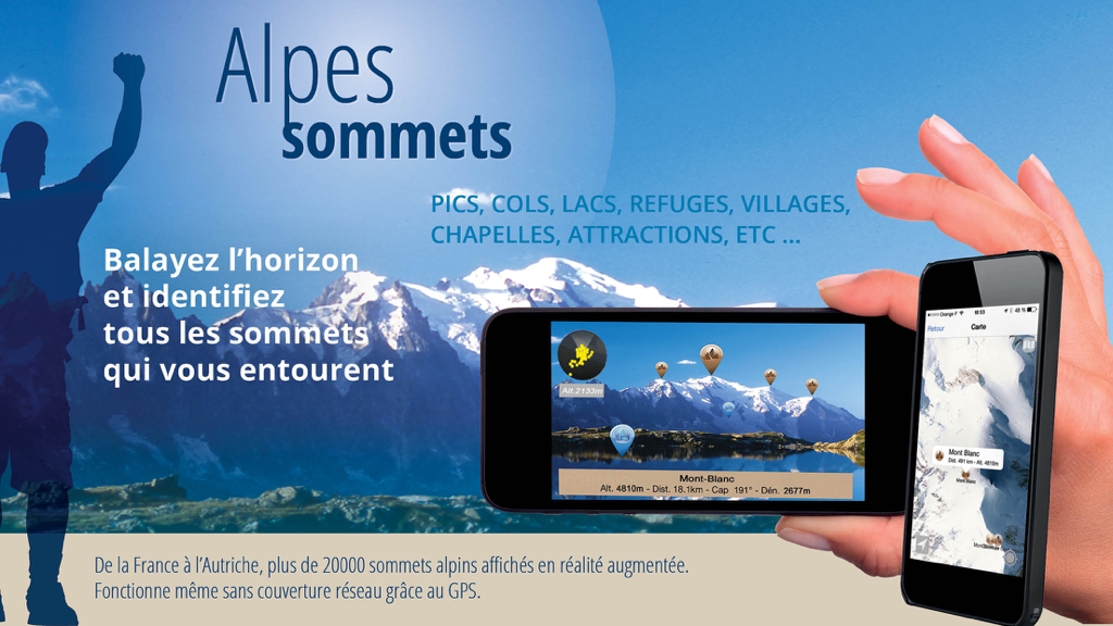
Alps Peaks ARアプリのマーケティング画像。スマートフォンで拡張現実の山頂識別とオフライン2Dマッピングを示しています
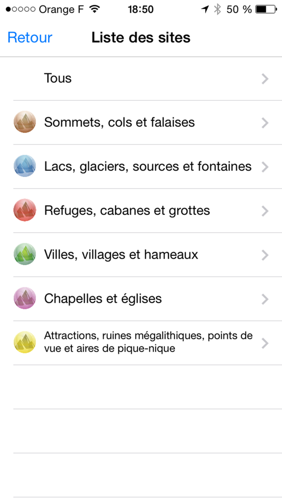
Alps Peaks ARアプリで、山頂、湖、避難所などの山岳関心事のカテゴリをリストしたメニュー画面
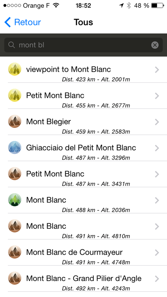
Alps Peaks ARアプリで、モンブランの検索結果リストに距離と標高が表示されています
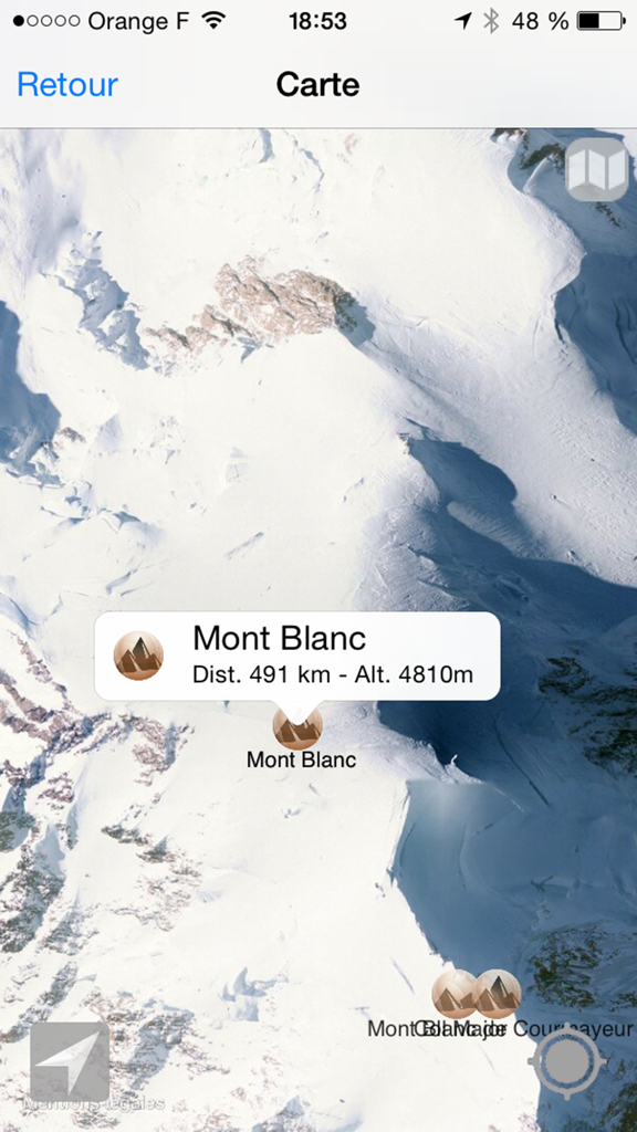
Alps Peaks ARアプリで、モンブランの衛星地図ビューに標高と距離が表示されています。
説明
Download
類似アプリ
同じカテゴリのトップランクアプリ

Uber - Request a ride
Uber Technologies, Inc.

Airbnb
Airbnb, Inc.

铁路12306
ACADEMY OF RAILWAY SCIENCES CO., ltd.

Booking.com: Hotels & Travel
Booking.com B.V.

Grab: Taxi Ride, Food Delivery
GRABTAXI HOLDINGS PTE. LTD.

Trip.com: Book Flights, Hotels
Trip.com Travel Singapore Pte. Ltd.

DiDi China: Ride Hailing
Didi Chuxing (Beijing) Network Platform Technology Co., Ltd

去哪儿旅行-订酒店机票火车票
Beijing Qunar Information Technology Company Limit

Bolt: Request a Ride
BOLT TECHNOLOGY OU
このページはアプリまたはその開発者の公式ページではなく、情報提供および論評を目的として作成された独立した編集出版物です。明示的に別段の記載がない限り、アプリおよびその開発者は、MWM、Apple、Google Play、アプリのパブリッシャー、またはアプリの開発者と提携、承認、後援、認可、またはその他の公式的な関係はなく、このページのいかなる内容も、アプリがMWMのサービスを使用して開発されたことを意味するものではありません。すべての商標、ロゴ、スクリーンショット、その他のコンテンツはそれぞれの所有者の財産です。