このページはアプリまたはその開発者の公式ページではなく、情報提供および論評を目的として作成された独立した編集出版物です。明示的に別段の記載がない限り、アプリおよびその開発者は、MWM、Apple、Google Play、アプリのパブリッシャー、またはアプリの開発者と提携、承認、後援、認可、またはその他の公式的な関係はなく、このページのいかなる内容も、アプリがMWMのサービスを使用して開発されたことを意味するものではありません。すべての商標、ロゴ、スクリーンショット、その他のコンテンツはそれぞれの所有者の財産です。

Bristol Maps
季節ごとの干潮時衛星画像で変動する砂州を航行し、高額な境界線違反を回避し、統合デジタルログとプライベートグループ調整でROIを最大化しましょう。
ダウンロード
300ユーザー評価
評価数
0開発元
カテゴリ
Navigation対応言語
-最新バージョン
3.13.1サイズ
413.0 MBリリース日
2023年5月7日操舵室のために作られ、傍観者のためではない
ブリストルマップは、荒々しいブリストル湾とコッパー川漁業に特化して設計された高解像度画像とデータ駆動型ツールで、プロの船員に必要な優位性を提供します。
干潮時衛星オーバーレイ
砂州がどこに移動したか推測するのはやめましょう。極端な干潮時に撮影された、キュレーションされた高解像度衛星画像にアクセスし、変化する水路を絶対的な自信を持って航行しましょう。
セキュアなコードグループ共有
あなたの優位性を保護しましょう。プライベートグループを使用して、ウェイポイント、ルート、ライブ位置情報を船団と安全に共有し、統合デジタルコードテーブルで古い紙の地図を置き換えましょう。
以下のスクリーンショットと説明は、アプリの公式ストアリスティングから直接取得されたものであり、アプリ開発者の所有物です。
アプリストア
スクリーンショット
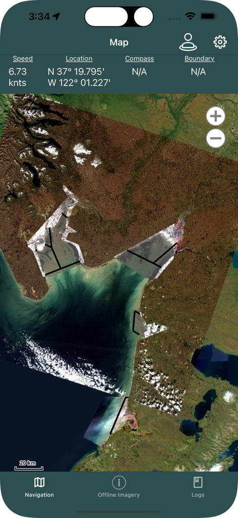
ブリストルマップアプリのナビゲーションインターフェース。漁場とリアルタイムの船位置を示す高解像度衛星画像が表示されています
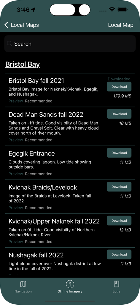
ブリストルマップアプリ。アラスカの漁場向けのダウンロード可能な衛星画像リストが表示されています
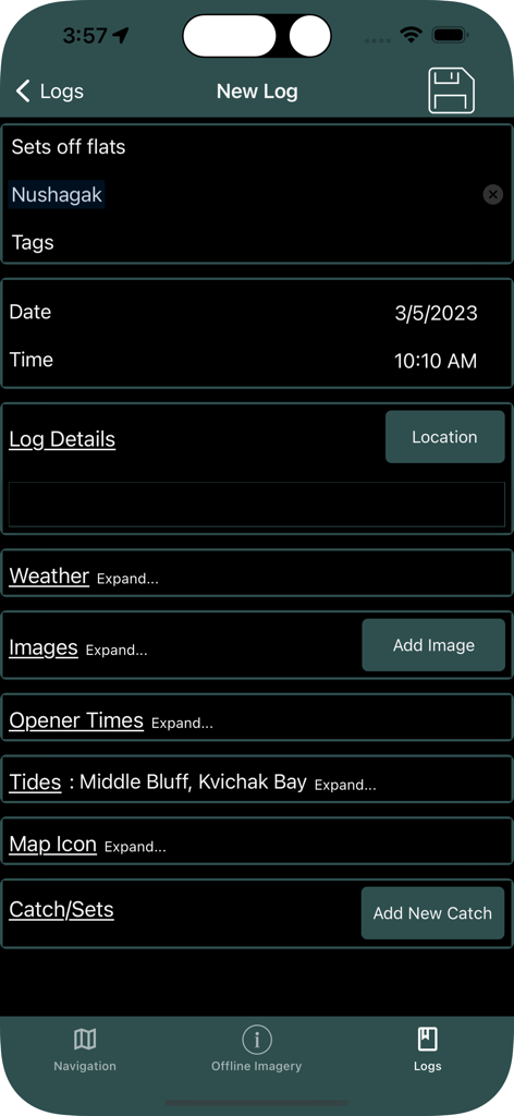
ブリストルマップアプリのインターフェース。場所、潮汐、漁獲量などの漁業データを記録するための新しいログエントリ画面が表示されています
説明
Download
類似アプリ
同じカテゴリのトップランクアプリ

Google Maps
Google LLC

AMap Global
AutoNavi Information Technology Co. Ltd.

Waze Navigation & Live Traffic
waze

百度地图-路线规划,出行必备
Beijing Baidu Netcom Science & Technology Co.,Ltd

Moovit: Bus & Transit Tracker
Moovit App Global LTD

Transit • Subway & Bus Times
9280-0366 Quebec inc.

ParkMobile: Park. Pay. Go.
Parkmobile USA, Inc

腾讯地图-路线规划,导航地铁打车出行
Shenzhen Tencent Computer Systems Company Limited

MapXplorer: Map Radar Navigate
GOLDLAB APPLICATIONS YAZILIM VE BILISIM ANONIM SIRKETI
このページはアプリまたはその開発者の公式ページではなく、情報提供および論評を目的として作成された独立した編集出版物です。明示的に別段の記載がない限り、アプリおよびその開発者は、MWM、Apple、Google Play、アプリのパブリッシャー、またはアプリの開発者と提携、承認、後援、認可、またはその他の公式的な関係はなく、このページのいかなる内容も、アプリがMWMのサービスを使用して開発されたことを意味するものではありません。すべての商標、ロゴ、スクリーンショット、その他のコンテンツはそれぞれの所有者の財産です。