このページはアプリまたはその開発者の公式ページではなく、情報提供および論評を目的として作成された独立した編集出版物です。明示的に別段の記載がない限り、アプリおよびその開発者は、MWM、Apple、Google Play、アプリのパブリッシャー、またはアプリの開発者と提携、承認、後援、認可、またはその他の公式的な関係はなく、このページのいかなる内容も、アプリがMWMのサービスを使用して開発されたことを意味するものではありません。すべての商標、ロゴ、スクリーンショット、その他のコンテンツはそれぞれの所有者の財産です。

ダウンロード
25M+ユーザー評価
評価数
796.1K開発元
カテゴリ
Navigation対応言語
13最新バージョン
11.40.1サイズ
254.2 MBリリース日
2011年10月18日アプリ「Citymapper: All Live Transit」の機能分析
都市移動を革新する主要機能の評価
リアルタイム到着予測と運行情報
ユーザーは、バスや電車がいつ到着するかをリアルタイムで確認し、乗り過ごしを防ぐことができます。また、車両の追跡、乗車に最適な車両の推奨、降車アラート、駅の最適な出口案内など、詳細な運行情報を活用できます。
リアルタイムの交通手段比較と多様な選択肢
ユーザーは、バス、地下鉄、電車、フェリー、タクシー、ライドシェア、カーシェア、自転車シェア、電動キックボード、徒歩など、あらゆる交通手段を組み合わせて最適なルートを瞬時に比較・計画できます。
広範な都市カバレッジと交通機関データ
本アプリは、世界中の主要都市で利用可能であり、各都市の公式交通機関から提供されるオープンデータを利用しています。これにより、ユーザーは信頼性の高い最新の交通情報を利用できます。
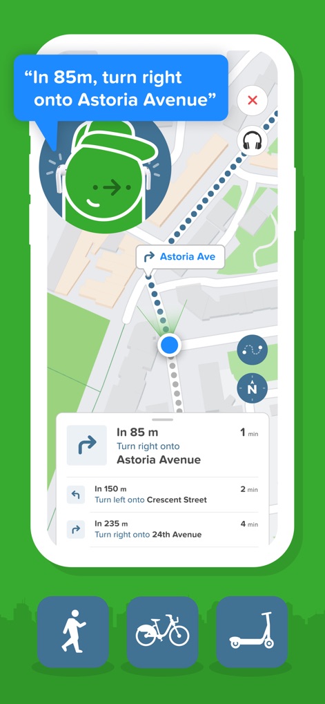
ターンバイターンナビゲーション
ユーザーは、公共交通機関、徒歩、自転車、電動キックボードでの移動において、詳細なターンバイターン方式のナビゲーションを受け取ることができます。3種類のマップビューの選択や、電動キックボードの充電レベル確認、駐車禁止区域の回避も可能です。
統合されたモビリティサービス
ユーザーは、アプリ内でタクシー運賃を比較したり、ライドシェアを呼んだり、シェア自転車や最寄りの電動キックボードを見つけたりすることができます。これにより、多様な交通手段へのアクセスが一元化されます。
パーソナライズされたルート計画
ユーザーは、自宅、職場、頻繁に利用する停留所や駅を保存し、迅速なルート計画に活用できます。また、お気に入りの路線を登録することで、自動的に運行中断、遅延、ステータスアラートを受け取ることができます。
位置情報共有
ユーザーは、リアルタイムで自分の移動状況を友人や家族と共有し、到着時間を知らせることができます。また、任意の場所や住所をワンタップで共有し、相手に道順案内を促すことが可能です。
オフラインマップアクセス
ユーザーは、公式の地下鉄やバスのマップをオフラインで利用できます。これにより、インターネット接続がない環境でも、主要な交通ルートを確認することが可能です。
よくある質問
について知っておくべきこと Citymapper: All Live Transit
What is Citymapper: All Live Transit?
Citymapper is an app that compares real-time travel options across all transport modes globally. It provides turn-by-turn directions for public transportation, walking, cycling, and scooter trips, helping users navigate cities efficiently.
Does Citymapper offer turn-by-turn directions for navigation?
Yes, Citymapper provides turn-by-turn navigation for transit, walking, personal cycling, bike shares, and scooter trips. It offers three different map views and highlights no-parking zones for scooters.
What transportation options does Citymapper support for trip planning?
Citymapper supports various transport modes, including bus, subway, train, ferry, cabs, ride shares, car shares, bike shares, e-scooters, and walking. It combines these for comprehensive trip planning.
Can Citymapper locate nearby e-scooters and shared bikes?
Yes, Citymapper helps users find the nearest shared bike or e-scooter directly within the app. It also allows comparing cab fares and hailing a ride from various partners.
Which ride-sharing and bike-sharing services are integrated with Citymapper?
Citymapper integrates with partners like Uber, Lyft, JUMP, Lime, Bird, Spin, Skip, Scoot, Citi Bike, and many others. This allows users to access various ride and bike-share services.
Does Citymapper provide real-time updates for public transportation?
Yes, Citymapper provides live wait times and ETAs for public transport like buses, trains, and ferries. It tracks vehicles on a real-time map and alerts users when to get off or for disruptions.
Can I save my favorite locations in the Citymapper app?
Yes, Citymapper allows users to save Home, Work, and frequent stops or stations. This personalization feature enables quicker trip planning and easier access to favorite routes.
Does Citymapper offer offline access to transit maps?
Yes, Citymapper provides offline access to official transit maps. These include maps for NYC subway, Manhattan bus, Brooklyn bus, Queens bus, DC metro, and Muni Metro.
What cities are covered by the Citymapper app?
Citymapper covers major cities worldwide, including New York City, Chicago, Los Angeles, San Francisco, Washington DC, Boston, and many others. A full list is available in the app or on its website.
How does Citymapper ensure the accuracy of its transit data?
Citymapper ensures data accuracy by utilizing open data from official transit agencies in the cities it covers. This includes agencies such as MTA, CTA, LA Metro, and MBTA.
以下のスクリーンショットと説明は、アプリの公式ストアリスティングから直接取得されたものであり、アプリ開発者の所有物です。
アプリストア
スクリーンショット

究極の交通手段
本アプリは、地図上での経路探索機能と、ニューヨークやロンドンを含む広範な都市カバー範囲を通じて、ユーザーの移動をサポートします。

多様な移動手段
本アプリは、鉄道やバス、自転車などの多様な交通手段のアイコン表示と、「Apple Apps of the Year」を5年連続受賞した実績で、ユーザーに信頼性の高い情報を提供します。

最適な経路比較
ユーザーは、歩行やスクーター、公共交通機関といった複数の交通手段をリアルタイムで比較でき、各オプションの所要時間と費用が一目で確認できます。

詳細な経路案内
本アプリは、地図上で表示されるターンバイターン方式のナビゲーションと、公共交通機関の「最適な乗り換え駅情報」を通じて、ユーザーを目的地へと確実に導きます。

乗り降りも安心
ユーザーは、「Get off now」アラートで降車タイミングを逃さず、駅の「最適な出口案内」機能でスムーズな移動を実現できます。

統合モビリティ
本アプリは、地図上に表示される多様なシェアサイクルやキックボードのサービスに加え、UberやLyftを含む多数の提携パートナーのロゴを通じて、幅広い移動手段へのアクセスを統合します。
音声経路ガイド
本アプリは、正確な音声ガイドによる経路案内と、歩行、自転車、スクーターの各移動手段に対応した詳細なテキスト指示の両方を提供し、ユーザーの移動をサポートします。

受賞歴多数
本アプリは、「Apple Apps of the Year」5年連続受賞に加え、ロンドン・デザイン・ミュージアムでの永久展示といった、数々の権威ある賞と認識を獲得しています。

秘密の移動術
アプリのマスコットキャラクターが「Tell no one」と示すジェスチャーは、Citymapperが提供する独自の移動のヒントやルート情報が、まるで「秘密兵器」のような価値を持つことを暗示しています。
説明
Download
類似アプリ
似た機能とユーザー体験を持つアプリ

百度地图-路线规划,出行必备
Beijing Baidu Netcom Science & Technology Co.,Ltd

GPS智能指南针-北斗卫星导航实时公交定位海拔测亩仪
Chengdu Yichituo Technology Co., Ltd.

Smart 5G Navigation
Chengdu Xinda Network Technology Co., Ltd.

VIP Real-time Map
Guangzhou Jishu Network Technology Co.,Ltd.

北斗导航-3D高清卫星地图Pro
Guangzhou Tianhe District Yongji Network Technology Co., Ltd.

Google Maps
Google LLC

腾讯地图-路线规划,导航地铁打车出行
Shenzhen Tencent Computer Systems Company Limited

Yandex Maps & Navigator
DIRECT CURSUS COMPUTER SYSTEMS TRADING LLC

KakaoMap - Korea No.1 Map
Kakao Corp.
このページはアプリまたはその開発者の公式ページではなく、情報提供および論評を目的として作成された独立した編集出版物です。明示的に別段の記載がない限り、アプリおよびその開発者は、MWM、Apple、Google Play、アプリのパブリッシャー、またはアプリの開発者と提携、承認、後援、認可、またはその他の公式的な関係はなく、このページのいかなる内容も、アプリがMWMのサービスを使用して開発されたことを意味するものではありません。すべての商標、ロゴ、スクリーンショット、その他のコンテンツはそれぞれの所有者の財産です。