このページはアプリまたはその開発者の公式ページではなく、情報提供および論評を目的として作成された独立した編集出版物です。明示的に別段の記載がない限り、アプリおよびその開発者は、MWM、Apple、Google Play、アプリのパブリッシャー、またはアプリの開発者と提携、承認、後援、認可、またはその他の公式的な関係はなく、このページのいかなる内容も、アプリがMWMのサービスを使用して開発されたことを意味するものではありません。すべての商標、ロゴ、スクリーンショット、その他のコンテンツはそれぞれの所有者の財産です。

Desert Maps: Navigator Offline
圏外の絶望を克服し、未踏の地を自らの意志で切り開く。このアプリは、ユーザーを地図上の神に変える。
ダウンロード
100k+ユーザー評価
評価数
3.2K開発元
カテゴリ
Navigation対応言語
44最新バージョン
8サイズ
147.9 MBリリース日
2025年2月5日リモートおよび砂漠環境向けナビゲーションツールの主要機能評価
Desert Maps: Navigator Offline アプリの機能分析
オフライン・圏外動作
このアプリは、インターネット接続やモバイルネットワークの圏外でも、砂漠や都市の両方で効率的に動作し、ユーザーに途切れないナビゲーション体験を提供します。
詳細なオフライン地図
このツールは、OpenStreetMapコミュニティの貢献により、他の地図では見つからない場所を含む、すべての国の詳細なオフライン地図を提供します。
経路追跡
ユーザーは、自分の移動経路を記録することで、同じルートを安全かつ快適に戻ることが可能です。
全ての座標タイプをサポート
本アプリは、あらゆる種類の座標の入力と共有をサポートしており、簡単なナビゲーションと計画を可能にします。
等高線と標高プロファイル
このアプリは、ユーザーにピーク、斜面、等高線の明確な詳細を提供し、地形の理解を深めます。
データのエクスポート・インポート
このツールは、ランドマークや地図をKML、KMZ、GPXなどの様々な形式でインポートおよびエクスポートする機能を提供します。
包括的なルーティングオプション
本アプリは、道路、直線、またはコンパスベースのナビゲーションをユーザーの好みに応じて提供し、包括的なルーティングを可能にします。
場所の保存とアクセス
ユーザーは、重要な場所を保存し、いつでも簡単にアクセスすることが可能です。
よくある質問
について知っておくべきこと Desert Maps: Navigator Offline
Does Desert Maps: Navigator Offline work without an internet connection?
Yes, the Desert Maps app operates efficiently in both deserts and cities without requiring an internet connection or mobile network coverage.
Is Desert Maps: Navigator Offline a free app?
No, Desert Maps offers a 3-day free trial to explore its features. After the trial, users must subscribe to a paid package to access professional features.
What navigation modes does the Desert Maps app support?
The Desert Maps app supports comprehensive navigation via roadways, direct line, or compass-based navigation. It also offers car, bicycle, and walking routes.
Where does Desert Maps: Navigator Offline get its detailed offline maps from?
The Desert Maps app provides detailed offline maps for all countries, sourced from the OpenStreetMap community. This allows for locations not found on other maps.
Can I record my trip's path with Desert Maps: Navigator Offline?
Yes, the Desert Maps app features trip tracking. You can record your trip's path to safely and comfortably return via the same route, and it records GPX tracks.
What data formats can Desert Maps: Navigator Offline import and export?
The Desert Maps app supports importing and exporting landmarks and maps in various formats, including KML, KMZ, and GPX.
Does Desert Maps: Navigator Offline support different coordinate types?
Yes, the Desert Maps app supports the input and sharing of all types of coordinates. This feature facilitates easy navigation and planning.
What new features are coming soon to the Desert Maps app?
Soon, the Desert Maps app will add features such as weather updates, rain radar, spring detection radar, and satellite imagery. The developers are open to suggestions.
以下のスクリーンショットと説明は、アプリの公式ストアリスティングから直接取得されたものであり、アプリ開発者の所有物です。
アプリストア
スクリーンショット
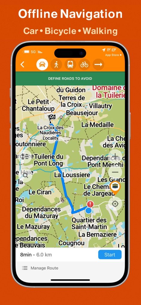
このアプリは、車や徒歩など複数の交通手段アイコンを上部に表示し、指定された目的地までの経路、所要時間、距離をユーザーに明瞭に提示します。
多彩な経路計画
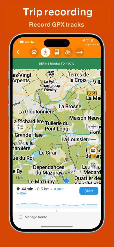
ユーザーは、移動したルートを青い点線で追跡し、下部には走行時間、距離、および標高変化のグラフが表示され、詳細な旅の記録が可能です。
旅の軌跡を記録
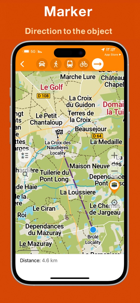
アプリは、地図上にオレンジ色のピンで示された目的地への方向を紫色の直線でガイドし、目的地までの残り距離(4.6km)を明瞭に表示します。
目印へ迷わず
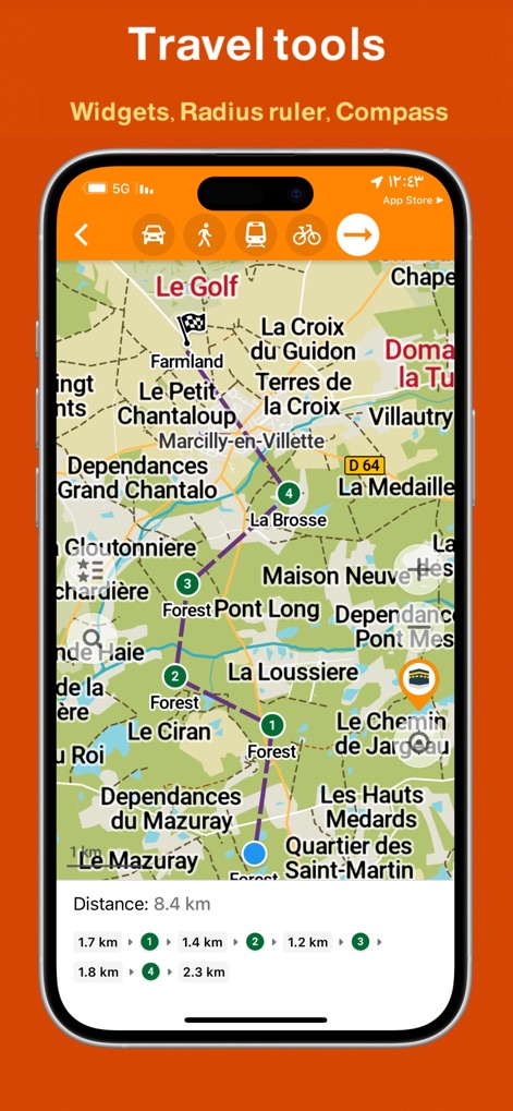
地図上には番号が振られた複数の地点が紫色の線で繋がり、各区間ごとの距離表示(例:1.7km 1、1.4km 2)により、ユーザーは詳細な経路情報を把握できます。
便利な旅行ツール
説明
Download
類似アプリ
似た機能とユーザー体験を持つアプリ

Detecht - Motorcycle App & GPS
Detecht Technologies AB

REVER - Motorcycle GPS & Rides
Rever, LLC

NYSSA Snowmobile Trails
Mapgears Inc.

Scenic Motorcycle Navigation
Applified Life Ltd.

Trails Offroad: Offline Maps
TRAILS OFFROAD LLC

Overland Bound One: Maps & GPS
Overland Bound Inc

Stegra.io - Motorcycle GPS
Stegraio AB

GoSnowmobiling NB
Mapgears Inc.

Lost Riders
Lost Riders, LLC
このページはアプリまたはその開発者の公式ページではなく、情報提供および論評を目的として作成された独立した編集出版物です。明示的に別段の記載がない限り、アプリおよびその開発者は、MWM、Apple、Google Play、アプリのパブリッシャー、またはアプリの開発者と提携、承認、後援、認可、またはその他の公式的な関係はなく、このページのいかなる内容も、アプリがMWMのサービスを使用して開発されたことを意味するものではありません。すべての商標、ロゴ、スクリーンショット、その他のコンテンツはそれぞれの所有者の財産です。