このページはアプリまたはその開発者の公式ページではなく、情報提供および論評を目的として作成された独立した編集出版物です。明示的に別段の記載がない限り、アプリおよびその開発者は、MWM、Apple、Google Play、アプリのパブリッシャー、またはアプリの開発者と提携、承認、後援、認可、またはその他の公式的な関係はなく、このページのいかなる内容も、アプリがMWMのサービスを使用して開発されたことを意味するものではありません。すべての商標、ロゴ、スクリーンショット、その他のコンテンツはそれぞれの所有者の財産です。

Earth-地球
指先で地球を支配する。このアプリは、グローバルな地形と衛星画像を圧倒的な精度で提供し、ユーザーに世界のあらゆる場所を探索し、測定する力を与える。
ダウンロード
2.5M+ユーザー評価
評価数
68.7K開発元
カテゴリ
Navigation対応言語
2最新バージョン
2.3.5サイズ
79.7 MBリリース日
2021年2月9日GIS専門家および高度な愛好家向けの高性能マッピングソリューション分析
「Earth-地球」主要機能の技術的評価
大規模高解像度履歴画像データ
本アプリケーションは、単一の年で70TBにも及ぶグローバルな高解像度履歴画像データを提供し、ユーザーが長期的な変化を分析し、より深い洞察を得ることを可能にします。
高速衛星・道路ネットワーク表示
ユーザーは、従来の地図サービスと比較して高速な衛星画像と道路ネットワーク表示を利用でき、効率的なデータアクセスと分析が可能です。
精密な3D地形表示
本アプリは、各業界のニーズに応える地理3D地形表示を提供し、複雑な地理的データを視覚化し、多角的な分析を行うことができます。
緯度経度による迅速な位置特定
緯度経度を直接入力することで、ユーザーは特定の地点に瞬時にアクセスでき、精密な調査や計画作業の効率が向上します。
広範な国際地域カバー
本アプリケーションは、中国市場に強く焦点を当てつつも、広範なグローバルデータカバレッジを提供し、多様な地域での計画、調査、および分析をサポートします。
衛星ナビゲーションと方位補正
方位磁石による位置補正機能を備えた衛星ナビゲーションは、ユーザーが正確な位置を特定し、特に都市計画や測量において、目的地の詳細な視覚化を可能にします。
夜間モード (地球の夜景表示)
夜間モードは、地球の夜景を視覚化する機能を提供し、特定の研究や教育目的、あるいは単なる視覚的探求に役立ちます。
飛行軌跡の可視化
ユーザーが位置を特定する際に、飛行軌跡を世界地図上に可視化することで、移動パターンや特定の経路を直感的に理解することができます。
よくある質問
について知っておくべきこと Earth-地球
What is the Earth-地球 app?
Earth-地球 is a satellite map application developed by Beidou Hanglu Company, designed as an alternative to Google Earth. It offers 3D geographical viewing and is optimized for speed.
Does the Earth-地球 app support 3D terrain viewing?
Yes, Earth-地球 supports 3D terrain viewing. The application can display geographical features in a three-dimensional format, meeting various industry needs.
Can users access street view imagery with the Earth-地球 app?
Yes, the Earth-地球 app provides high-definition global street view imagery. Users can access street-level perspectives and navigate directly.
Does the Earth-地球 app include a night mode feature?
Yes, Earth-地球 features a night mode. This allows users to observe the Earth's night scenery and illuminated areas.
What kind of data does the 元地球Earth app utilize for its maps?
The 元地球Earth app utilizes massive amounts of data, including 70TB of high-definition global historical imagery data for a single year.
Can the Earth-地球 app be used to measure distances and calculate areas?
Yes, Earth-地球 provides tools for measuring both distances and areas directly on the map interface. This feature is available for user convenience.
Which countries and regions does the Earth-地球 app support for its electronic maps?
The Earth-地球 app supports numerous countries and regions worldwide, including China, Japan, Thailand, Korea, USA, Canada, and many others across Asia, Europe, Africa, and the Americas.
Does the Earth-地球 app support satellite navigation and positioning?
Yes, Earth-地球 supports satellite navigation. It uses a compass to correct positioning and helps users find specific locations like their home rooftops.
Can users input latitude and longitude coordinates in the 元地球Earth app?
Yes, 元地球Earth allows users to input latitude and longitude coordinates. This enables quick positioning to specific street views without external tools.
What future features are planned for the 元地球Earth app?
Future updates for 元地球Earth will include CAD file submission, navigation, GPS measurement tools, map sharing, weather data, ocean currents, friend location viewing, and compass functions.
以下のスクリーンショットと説明は、アプリの公式ストアリスティングから直接取得されたものであり、アプリ開発者の所有物です。
アプリストア
スクリーンショット

このアプリは、エッフェル塔を捉えた高解像度衛星画像を提供し、精密な地理情報と多機能ツールバーによる直感的な操作が可能です。
俯瞰の地球
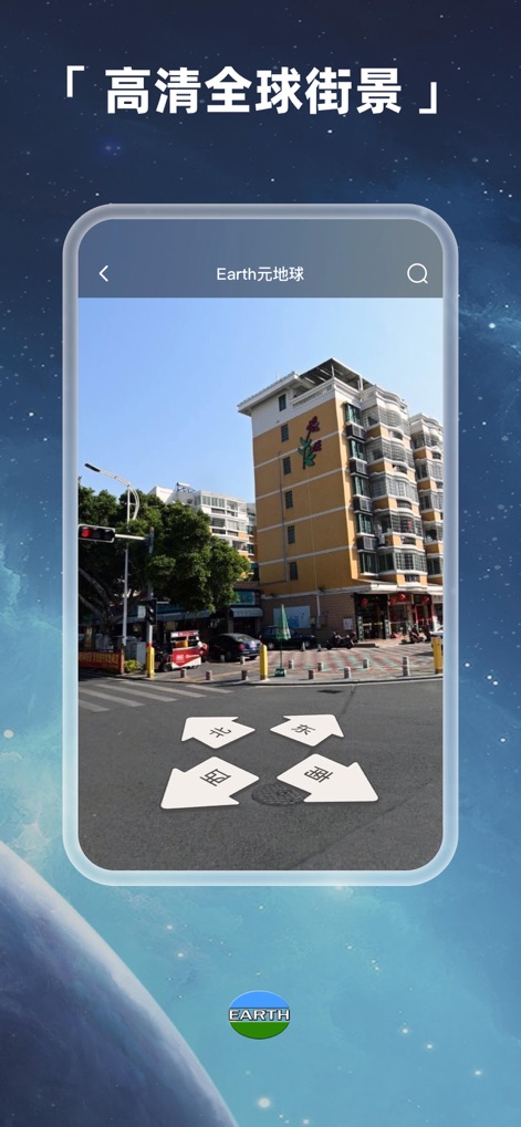
高精細な街並み画像でリアルな探索体験を提供し、地上の方向指示マーカーがユーザーの移動をサポートします。
リアルな街並み

本アプリは、詳細な立体的な山岳地形を表示し、地名表示機能により地理的特徴を正確に把握できます。
3D地形ビュー

衛星画像上で詳細な方位盤を用いて方角を特定し、リアルタイムの経緯度情報表示で現在地を正確に確認できます。
精密な方位

港湾エリアの衛星画像上で距離・面積計測が可能で、計測結果が直感的なビジュアル表示で可視化されます。
測距と測量
説明
Download
類似アプリ
似た機能とユーザー体験を持つアプリ

Living Earth - Clock & Weather
Radiantlabs, LLC

WeatherMap+
Michal Frankowski

Globe Earth 3D - Live Map
Zipo Apps Ltd.

World Map Pro Edition
Appventions

Geo Walk - World Factbook 3D
Vito Technology Inc.

Atlas Pro: Maps & Facts
Appventions

World Map +
Appventions

WorldPulse Earth Weather Clouds & Temperature
Corporate Smalltalk Consulting Ltd

Liveuamap
Rodion Rozhkovsky
このページはアプリまたはその開発者の公式ページではなく、情報提供および論評を目的として作成された独立した編集出版物です。明示的に別段の記載がない限り、アプリおよびその開発者は、MWM、Apple、Google Play、アプリのパブリッシャー、またはアプリの開発者と提携、承認、後援、認可、またはその他の公式的な関係はなく、このページのいかなる内容も、アプリがMWMのサービスを使用して開発されたことを意味するものではありません。すべての商標、ロゴ、スクリーンショット、その他のコンテンツはそれぞれの所有者の財産です。