このページはアプリまたはその開発者の公式ページではなく、情報提供および論評を目的として作成された独立した編集出版物です。明示的に別段の記載がない限り、アプリおよびその開発者は、MWM、Apple、Google Play、アプリのパブリッシャー、またはアプリの開発者と提携、承認、後援、認可、またはその他の公式的な関係はなく、このページのいかなる内容も、アプリがMWMのサービスを使用して開発されたことを意味するものではありません。すべての商標、ロゴ、スクリーンショット、その他のコンテンツはそれぞれの所有者の財産です。

Geo Timestamp : GPS Map Camera
フィールド検査、不動産、プロフェッショナルなレポート作成に最適なドキュメンテーションツール。正確なGPS座標、地図オーバーレイ、タイムスタンプを自動で埋め込み、オフライン場所でも検証可能な記録を即座に作成します。
ダウンロード
8K+ユーザー評価
評価数
0開発元
カテゴリ
Navigation対応言語
1最新バージョン
1.6サイズ
47.2 MBリリース日
2025年9月1日クリックごとに精密なドキュメンテーション
GPS、地図オーバーレイ、タイムスタンプデータを自動で追加し、プロフェッショナルや冒険家向けの検証可能な記録に写真を変換します。
自動プロフェッショナルスタンプ
GPS座標、正確な住所、時刻同期スタンプを即座に埋め込み、検査や旅行記録のために、否定できない作業証明を提供します。
統合地図オーバーレイ
衛星または標準地図ビューで正確な位置を可視化し、画像に直接焼き付け、すべてのショットに即時の地理的コンテキストを提供します。
よくある質問
について知っておくべきこと Geo Timestamp : GPS Map Camera
Geo Timestamp: GPS Map Cameraとは何ですか?
Geo Timestamp: GPS Map Cameraは、写真に自動的にGPS座標、地図表示、日付、時刻スタンプを追加するカメラアプリです。写真がどこでいつ撮影されたかを記録します。
Geo Timestamp: GPS Map Cameraは写真に自動的にGPS位置を追加しますか?
はい、Geo Timestamp: GPS Map Cameraは、撮影したすべての写真に現在のGPS座標と住所情報を自動的に追加します。自動GPS検出もサポートしています。
Geo Timestamp: GPS Map Cameraは写真に日付と時刻スタンプを追加できますか?
はい、このアプリは記録および検証のために、各写真に正確な日付と時刻を自動的に追加します。これはGeo Timestampアプリのコア機能です。
Geo Timestamp: GPS Map Cameraは写真に地図オーバーレイを提供しますか?
はい、Geo Timestamp: GPS Map Cameraは、衛星、ハイブリッド、または標準の地図スタイルで、写真の場所に直接地図を表示し、画像にオーバーレイします。
Geo Timestamp: GPS Map CameraはインターネットやGPS信号なしで使用できますか?
はい、Geo Timestamp: GPS Map Cameraはオフラインモードをサポートしています。インターネットやGPS信号が弱い場合でも、ユーザーは写真をキャプチャして保存できます。
Geo Timestamp: GPS Map Cameraで手動で位置を調整することは可能ですか?
はい、Geo Timestampアプリは手動位置オプションを提供しています。自動GPS検出が利用できない場合、ユーザーは特定のマッピングポイントを調整または選択できます。
Geo Timestamp: GPS Map Cameraから写真を共有するにはどうすればよいですか?
Geo Timestamp: GPS Map Cameraでは、簡単に共有できます。ユーザーは、ジオタグとタイムスタンプが付いた写真を電子メール、チャット、またはソーシャルメディア経由で即座に共有できます。
Geo Timestamp: GPS Map Cameraの使用から誰が利益を得ますか?
Geo Timestamp: GPS Map Cameraアプリは、写真のタイムスタンプ、地図上の位置、検証可能なデータを必要とする旅行者、エンジニア、測量士、不動産業者、およびフィールドワーカーに理想的です。
Geo Timestamp: GPS Map Cameraは位置情報用のデザイン済みテンプレートを提供しますか?
はい、このアプリは、旅行、作業レポート、フィールド検査用のプロフェッショナルなテンプレートスタイルを提供します。ナビゲーションコンパスやクラシックテンプレートなどのオプションが含まれています。
Geo Timestamp: GPS Map Cameraは写真にどのような情報を埋め込みますか?
Geo Timestamp: GPS Map Cameraアプリは、緯度・経度、住所・地図表示、日付・時刻、コンパスの向き、高度(有効な場合)を写真に自動的にスタンプします。
以下のスクリーンショットと説明は、アプリの公式ストアリスティングから直接取得されたものであり、アプリ開発者の所有物です。
アプリストア
スクリーンショット
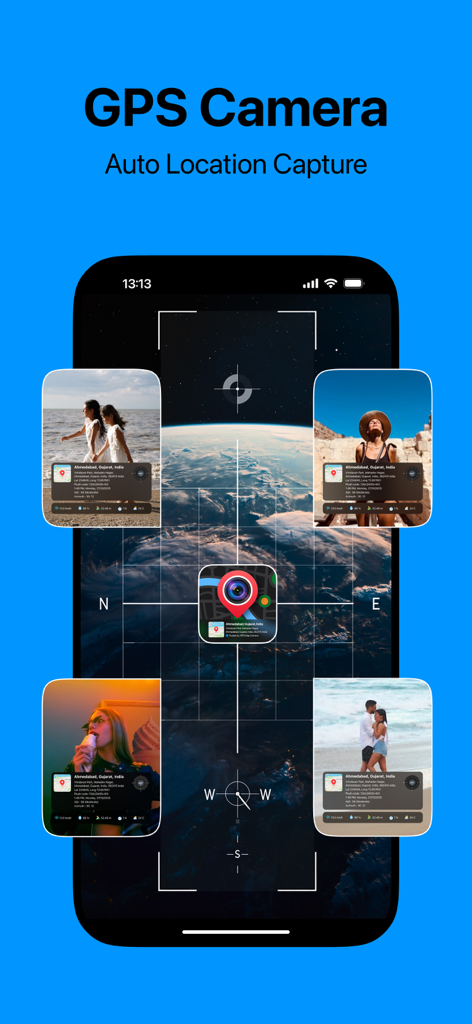
GPS Map Cameraアプリのインターフェース。自動位置情報キャプチャと写真のタイムスタンプ、地図オーバーレイが表示されています
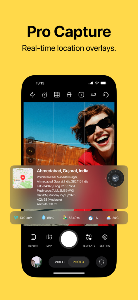
モバイルアプリのインターフェース。リアルタイムのGPS位置情報データと地図オーバーレイ付きの写真が表示されています
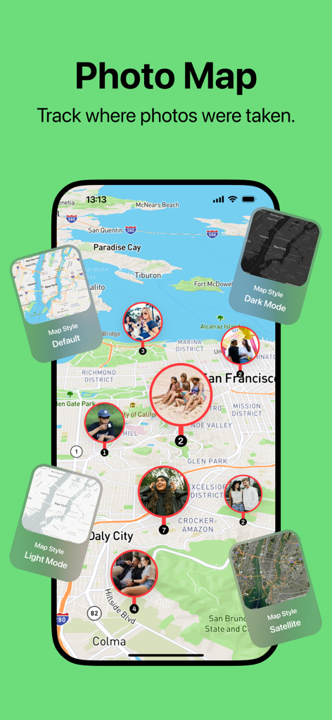
写真マップ機能。さまざまな地図スタイルオプションとともに、地図上の写真の位置が表示されています
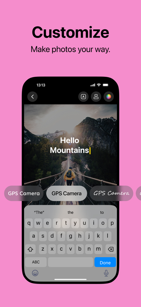
スマートフォンのインターフェース。山々のGPSタグ付き写真で、フォントやテキストのカスタマイズオプションが表示されています
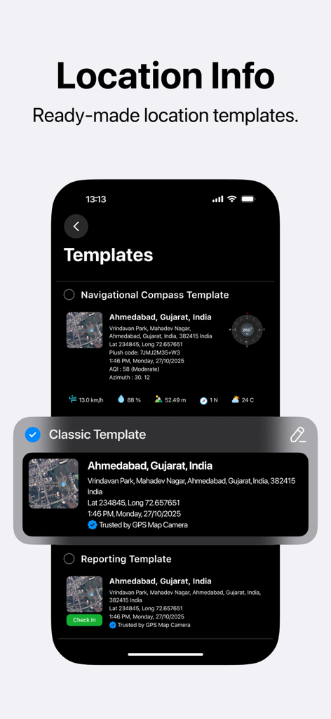
モバイルアプリのインターフェース。GPS写真スタンプ用の既製の場所情報テンプレートが表示されています
説明
Download
類似アプリ
同じカテゴリのトップランクアプリ

Google Maps
Google LLC

Waze Navigation & Live Traffic
waze

AMap Global
AutoNavi Information Technology Co. Ltd.

百度地图-路线规划,出行必备
Beijing Baidu Netcom Science & Technology Co.,Ltd

Moovit: Bus & Transit Tracker
Moovit App Global LTD

Transit • Subway & Bus Times
9280-0366 Quebec inc.

ParkMobile: Park. Pay. Go.
Parkmobile USA, Inc

腾讯地图-路线规划,导航地铁打车出行
Shenzhen Tencent Computer Systems Company Limited

Île-de-France Mobilités
Ile de France Mobilites
このページはアプリまたはその開発者の公式ページではなく、情報提供および論評を目的として作成された独立した編集出版物です。明示的に別段の記載がない限り、アプリおよびその開発者は、MWM、Apple、Google Play、アプリのパブリッシャー、またはアプリの開発者と提携、承認、後援、認可、またはその他の公式的な関係はなく、このページのいかなる内容も、アプリがMWMのサービスを使用して開発されたことを意味するものではありません。すべての商標、ロゴ、スクリーンショット、その他のコンテンツはそれぞれの所有者の財産です。