このページはアプリまたはその開発者の公式ページではなく、情報提供および論評を目的として作成された独立した編集出版物です。明示的に別段の記載がない限り、アプリおよびその開発者は、MWM、Apple、Google Play、アプリのパブリッシャー、またはアプリの開発者と提携、承認、後援、認可、またはその他の公式的な関係はなく、このページのいかなる内容も、アプリがMWMのサービスを使用して開発されたことを意味するものではありません。すべての商標、ロゴ、スクリーンショット、その他のコンテンツはそれぞれの所有者の財産です。

GPS-Tracker Pro
データ主導の探求者向け高度ユーティリティ。高忠実度メトリクス、ダイナミック速度マップ、プログレードのGPX、KML、CSVエクスポートで、あらゆるハイキング、ドライブ、フライトを記録します。
ダウンロード
374K+ユーザー評価
評価数
200開発元
カテゴリ
Navigation対応言語
2最新バージョン
1.8サイズ
1.9 MBリリース日
2015年7月17日あらゆる旅のための高精度トラッキング
山のトレイルから飛行経路まで、プログレードのGPSロギングと高度なデータ視覚化で、アクティビティのあらゆる詳細をキャプチャします。
包括的なデータインサイト
あらゆるアクティビティでのパフォーマンス分析に役立つ、正確な統計情報でリアルタイムの速度、高度、距離を監視します。
視覚的な速度マッピング
速度の変化を地図上に直接表示する、ダイナミックでマルチカラーの経路表示でペースを視覚化します。
プログレードのデータポータビリティ
GPX、KML、またはCSV形式でのシームレスなエクスポートでデータを制御します。iPadやデスクトップソフトウェアでの分析に最適です。
カスタムマーカーと高度な統計
カスタムロケーションマーカーをドロップし、走行距離、平均速度、最大高度などの詳細な統計情報でパフォーマンスを追跡します。
以下のスクリーンショットと説明は、アプリの公式ストアリスティングから直接取得されたものであり、アプリ開発者の所有物です。
アプリストア
スクリーンショット
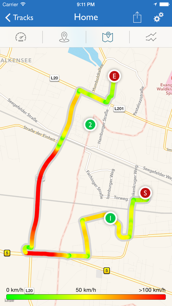
GPS-Tracker Proアプリの地図上に表示されたマルチカラーのルートトラック。経路に沿った速度の変化を示しています。
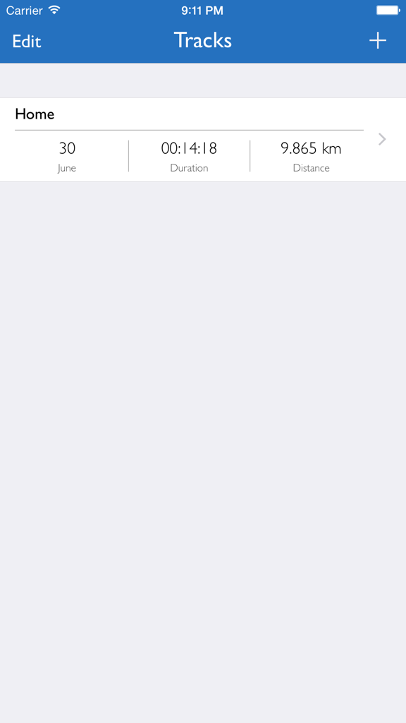
GPS-Tracker Proアプリのインターフェース。走行時間や距離などの旅行詳細が表示された記録されたGPSトラックのリストを表示しています。
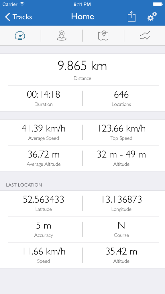
GPS-Tracker Proダッシュボード。距離、速度、高度、地理座標の追跡データが表示されています。
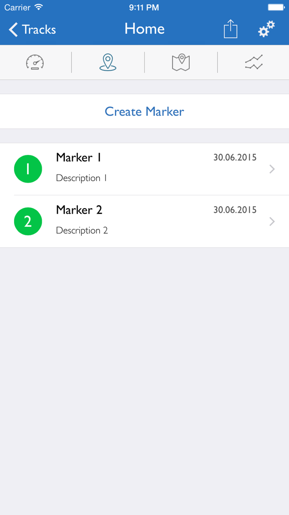
GPS-Tracker Pro画面。日付と説明が表示されたカスタムロケーションマーカーのリストを表示しています。
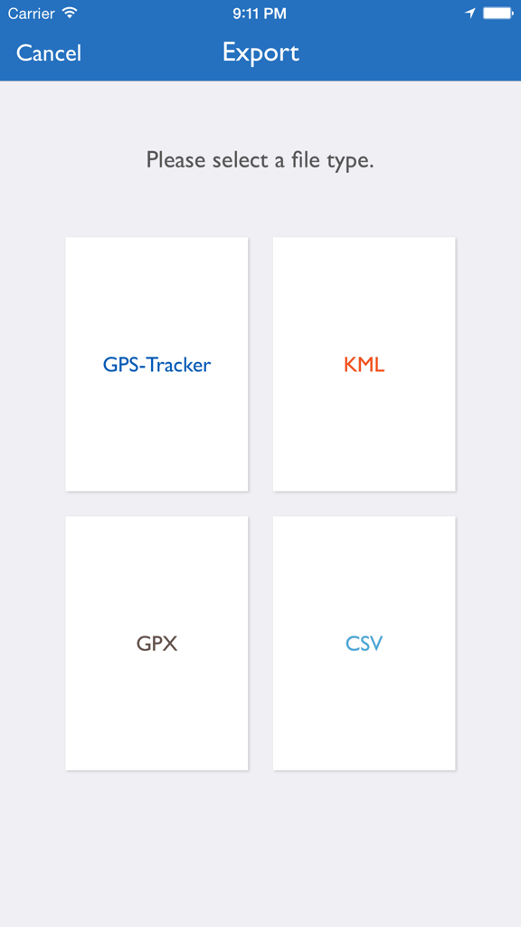
GPS-Tracker Proのエクスポートインターフェース。KML、GPX、CSVファイル形式の選択オプションが表示されています。
説明
Download
類似アプリ
同じカテゴリのトップランクアプリ

Google Maps
Google LLC

Waze Navigation & Live Traffic
waze

AMap Global
AutoNavi Information Technology Co. Ltd.

百度地图-路线规划,出行必备
Beijing Baidu Netcom Science & Technology Co.,Ltd

Moovit: Bus & Transit Tracker
Moovit App Global LTD

Transit • Subway & Bus Times
9280-0366 Quebec inc.

ParkMobile: Park. Pay. Go.
Parkmobile USA, Inc

腾讯地图-路线规划,导航地铁打车出行
Shenzhen Tencent Computer Systems Company Limited

Île-de-France Mobilités
Ile de France Mobilites
このページはアプリまたはその開発者の公式ページではなく、情報提供および論評を目的として作成された独立した編集出版物です。明示的に別段の記載がない限り、アプリおよびその開発者は、MWM、Apple、Google Play、アプリのパブリッシャー、またはアプリの開発者と提携、承認、後援、認可、またはその他の公式的な関係はなく、このページのいかなる内容も、アプリがMWMのサービスを使用して開発されたことを意味するものではありません。すべての商標、ロゴ、スクリーンショット、その他のコンテンツはそれぞれの所有者の財産です。