このページはアプリまたはその開発者の公式ページではなく、情報提供および論評を目的として作成された独立した編集出版物です。明示的に別段の記載がない限り、アプリおよびその開発者は、MWM、Apple、Google Play、アプリのパブリッシャー、またはアプリの開発者と提携、承認、後援、認可、またはその他の公式的な関係はなく、このページのいかなる内容も、アプリがMWMのサービスを使用して開発されたことを意味するものではありません。すべての商標、ロゴ、スクリーンショット、その他のコンテンツはそれぞれの所有者の財産です。

Navitel Navigator
66カ国を完全にオフラインで独立してナビゲート。大型車両向けの特殊貨物ルーティングからプレミアムヘッドアップディスプレイ(HUD)テクノロジーまで、信号を必要とせずに、道路がどこへ導いてもプロフェッショナルグレードの精度が得られます。
ダウンロード
1M+ユーザー評価
評価数
3K+開発元
カテゴリ
Navigation対応言語
36最新バージョン
12.6.1433サイズ
93.8 MBリリース日
2013年3月5日意欲的なプロフェッショナルのための高精度ナビゲーション
州をまたいで貨物を輸送する場合でも、国際都市を探索する場合でも、Navitel Navigatorは標準的なアプリでは対応できないオフラインの信頼性と特殊なルーティングを提供します。
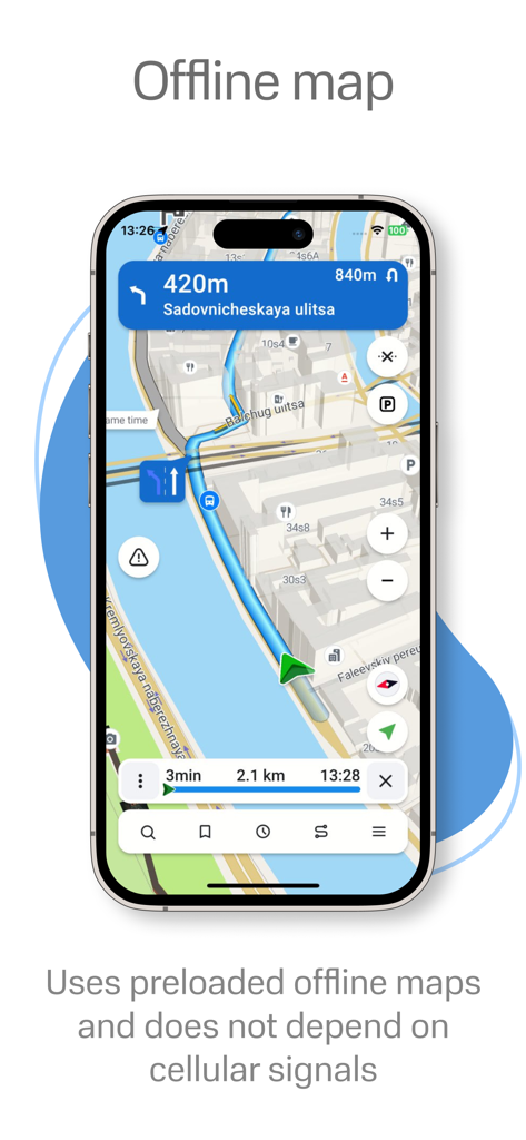
データ不要の信頼性
詳細なオフラインマップで66カ国をナビゲート。通信範囲外の田舎でも現在地を把握し、100%自律的なGPSで国際ローミング料金を回避します。
特殊貨物ロジック
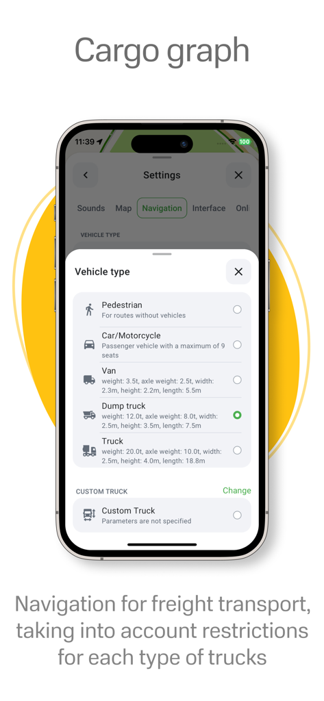
3.5トンから40トン超の大型車両向けに設計。重量制限、橋の高さ、商業道路の規制を自動的に考慮したルートを計画します。
よくある質問
について知っておくべきこと Navitel Navigator
Navitel Navigatorはオフラインマップに対応していますか?
はい、Navitel Navigatorはオフラインマップに対応しています。ユーザーは66カ国の地図をダウンロードし、インターネット接続なしで使用できるため、ローミング料金を節約し、通信環境の悪い地域でもナビゲーションを確保できます。
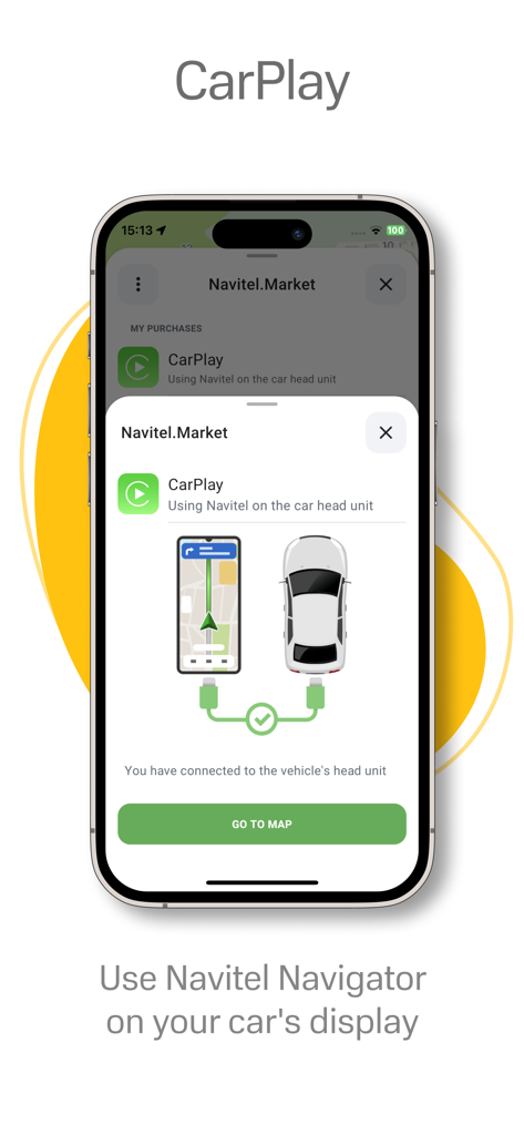
Navitel NavigatorはApple CarPlayに対応していますか?
はい、Navitel NavigatorはApple CarPlayに対応しています。ユーザーは、シームレスな車内体験のために、ナビゲーションを車のヘッドユニットに表示して使用できます。
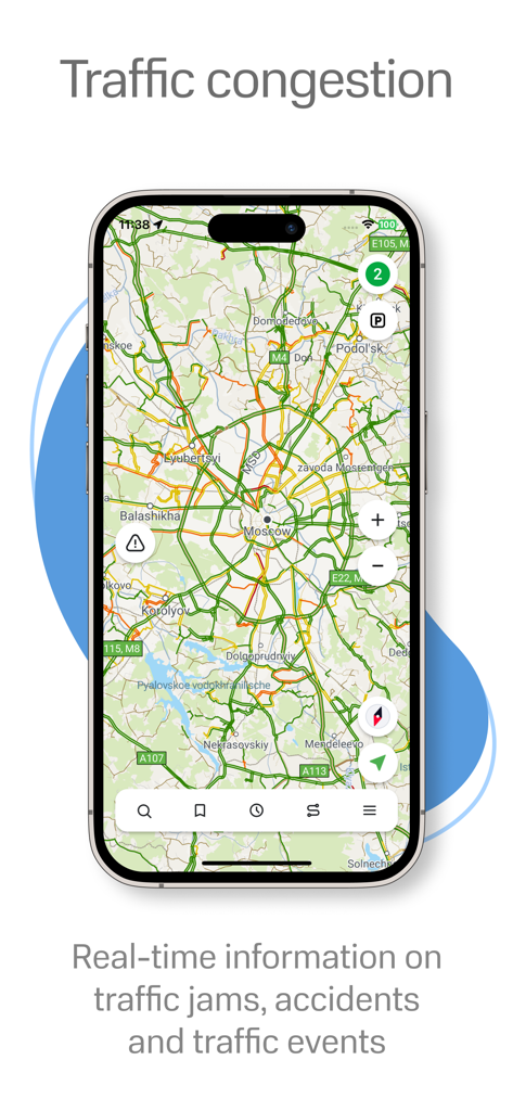
Navitel Navigatorはリアルタイム交通情報を提供していますか?
はい、Navitel NavigatorはNavitel.Trafficを通じてリアルタイム交通情報を提供しています。渋滞、事故、工事、その他のインシデントを表示し、ルートを最適化するのに役立ちます。
Navitel Navigatorはトラック向けのナビゲーションを提供していますか?
はい、Navitel Navigatorにはトラック向けのCargo graphが搭載されています。3.5トンから40トン以上の車両、およびカスタムトラックパラメータを考慮した道路標識と特定の制限を考慮してルートを構築します。
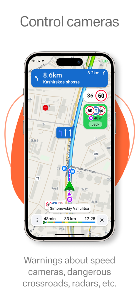
Navitel Navigatorはスピードカメラやレーダーについて警告しますか?
はい、Navitel NavigatorはSpeedCam警告を提供します。レーダー、スピードカメラ、道路制限についてユーザーに通知し、運転の安全性と意識を高めます。
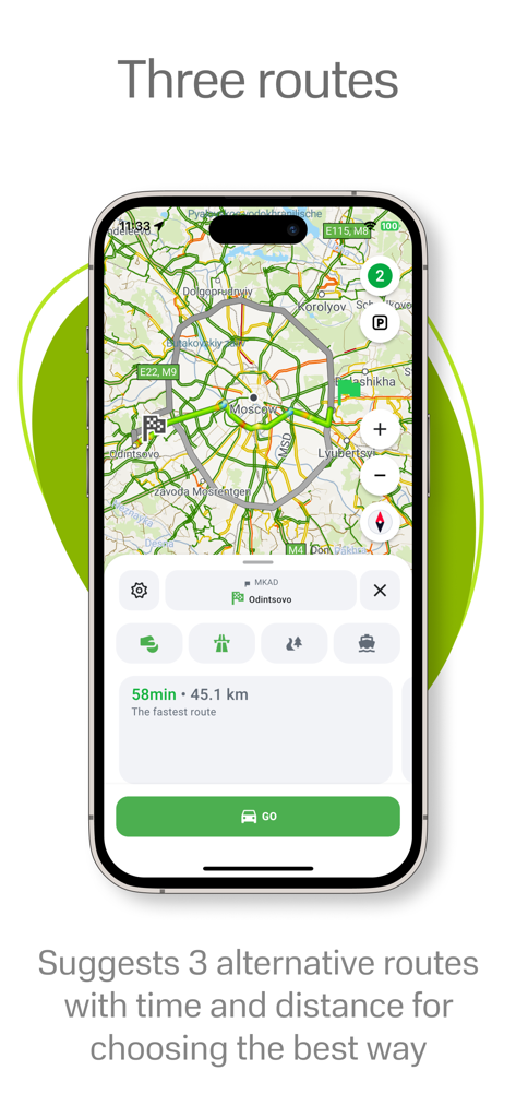
Navitel Navigatorはいくつの代替ルートを提案しますか?
Navitel Navigatorは3つの代替ルートを提案します。各ルートには距離と推定所要時間の詳細情報が含まれており、ユーザーは最も適切なオプションを選択できます。
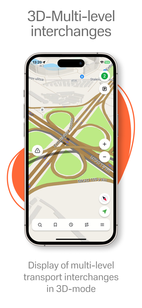
Navitel Navigatorは3Dで地図を表示しますか?
はい、Navitel Navigatorは3Dで地図を表示します。テクスチャと建物の高さを備えた3Dマップが含まれており、多層道路交差点も3Dモードで表示されます。
Navitel Navigatorのサポートに連絡するにはどうすればよいですか?
Navitel Navigatorのサポートには、support@navitel.czにメールで連絡できます。サポートチームは、アプリケーションに関するご質問や問題に対応します。
以下のスクリーンショットと説明は、アプリの公式ストアリスティングから直接取得されたものであり、アプリ開発者の所有物です。
アプリストア
スクリーンショット
説明
Download
類似アプリ
似た機能とユーザー体験を持つアプリ

MAPS.ME: Offline Maps, GPS Nav
Convexity Holdings AG

CoMaps
Anton Wenemoser

GPS Navigation & Path Finder
Muhammad Asad Khan

MapFactor Navigator - GPS Maps
MAPFACTOR, s.r.o.

Guru Maps Pro & GPS Tracker
Evgen Bodunov

Offline Map Navigation
virtualmaze

Karta GPS - Offline Maps Nav
Karta Software Technologies lda

Genius Maps: GPS Navigation
Mireo d.d.

NaviMaps: 3D GPS Navigation
CE Info Systems Limited
このページはアプリまたはその開発者の公式ページではなく、情報提供および論評を目的として作成された独立した編集出版物です。明示的に別段の記載がない限り、アプリおよびその開発者は、MWM、Apple、Google Play、アプリのパブリッシャー、またはアプリの開発者と提携、承認、後援、認可、またはその他の公式的な関係はなく、このページのいかなる内容も、アプリがMWMのサービスを使用して開発されたことを意味するものではありません。すべての商標、ロゴ、スクリーンショット、その他のコンテンツはそれぞれの所有者の財産です。