このページはアプリまたはその開発者の公式ページではなく、情報提供および論評を目的として作成された独立した編集出版物です。明示的に別段の記載がない限り、アプリおよびその開発者は、MWM、Apple、Google Play、アプリのパブリッシャー、またはアプリの開発者と提携、承認、後援、認可、またはその他の公式的な関係はなく、このページのいかなる内容も、アプリがMWMのサービスを使用して開発されたことを意味するものではありません。すべての商標、ロゴ、スクリーンショット、その他のコンテンツはそれぞれの所有者の財産です。

ok2fly
リアルタイムのCASA安全規則、4D NOTAM、精密な時間計画により、オーストラリアの空をマスターしましょう。真剣なホビイストとReOC保有者の両方に対応するように設計されています。
ダウンロード
43K+ユーザー評価
評価数
0開発元
カテゴリ
Navigation対応言語
1最新バージョン
1.6.0サイズ
75.6 MBリリース日
2022年1月12日絶対的な自信を持ってミッションを計画しましょう
プロおよびレクリエーションのドローンパイロット向けの究極の安全ツール。CASA準拠のデータと高精度の4D状況認識を組み合わせ、機器とライセンスを保護します。
公式CASA統合型コンプライアンス
CASA RPASプラットフォームと完全に統合されたツールで、完全な安心感を持って飛行しましょう。現在の安全規則を遵守し、Airservices Australiaの公式認証トライアルに直接アクセスできます。
超ローカルな状況認識
「グリーンライト」以上のものを提供します。4D制限空域、空港エンベロープ、リアルタイムNOTAMを、学校、刑務所、公園などの地域のランドマークとともに視覚化し、法的紛争を回避します。
よくある質問
について知っておくべきこと ok2fly
ok2flyとは何ですか?
ok2flyは、パイロットがミッションを計画し、空域を視覚化し、規制への準拠を確実にするのに役立つドローン安全ツールです。詳細な地図とリアルタイムの運用環境分析を提供します。
ok2flyはドローンの飛行禁止区域を表示しますか?
はい、ok2flyは滑走路の広がり、空港のエンベロープの詳細な視覚化を提供し、制限区域と危険区域を自動的に視覚化します。アクティブな管制塔に基づいて飛行禁止区域を特定します。
ok2flyは飛行計画にどのように役立ちますか?
ok2flyは、設定可能な半径で直近のドローン飛行エリアを調査し、詳細な場所レポートを提供し、提案された飛行時刻の活動を反映するように地図情報を調整します。
ok2flyはドローン飛行に関するCASA規制に準拠していますか?
はい、ok2flyはCASA RPAS安全規則に完全に準拠しており、CASA RPASプラットフォームと統合されています。CASA / Airservices Australiaの空域認可トライアルの一部でした。
ok2flyは詳細な飛行レポートを提供できますか?
はい、ok2flyは、お客様の場所周辺の空域を分析し、詳細な場所レポートを提供します。このレポートには、運用空域で検出されたすべての既知のランドマークが含まれています。
ok2flyはドローンを飛行できるかどうかを示しますか?
はい、ok2flyは、提案された飛行エリアと選択されたパイロット資格の分析に基づいて、「飛行可能」、「飛行不可」、「条件付きで飛行可能」などの明確な表示を提供します。
ok2flyはオーストラリアのどのような地図データを提供しますか?
ok2flyは、オーストラリア全土の通りレベルのベクトル地図を提供します。標準的な通りの情報、障害物、低レベルの航空活動、レクリエーションサイトなどの航空情報が含まれています。
ok2flyで地図にオーバーレイを追加できますか?
はい、ok2flyは、航空交通、気象、雷などの動的なオプションを含む追加の地図オーバーレイをサポートしています。FIA周波数境界や管制空域などの静的なオーバーレイも利用可能です。
ok2flyはドローン運用に関するリアルタイムNOTAMを表示しますか?
はい、ok2flyはドローン運用に影響を与えるNOTAM活動を自動的に視覚化します。また、有料サブスクリプションでは、制限区域および危険区域のNAIPS NOTAM情報を継続的に更新して提供します。
ok2flyを特定のドローンパイロット資格に合わせて設定できますか?
はい、ok2flyは4つのCASAパイロットタイプ(Micro、Recreational、Commercial Excluded、ReOC)をサポートしています。ユーザーは設定機能からパイロットタイプを選択して、資格に合わせることができます。
ok2flyのすべての機能に有料サブスクリプションが必要ですか?
いいえ、ok2flyの一部の高度な機能には有料サブスクリプションが必要です。これらには、Commercial ExcludedおよびReOCパイロットタイプ、Layersオプション、NAIPS NOTAM検査、無線周波数データが含まれます。
ok2flyの有料サブスクリプションには何が含まれますか?
有料のok2flyサブスクリプションには、Commercial Excluded / ReOCパイロットタイプ、高度な地図レイヤー、NAIPS NOTAM検査、無線周波数データ、およびAvPlan-EFB Standard Plusアクセスなどの機能へのアクセスが含まれます。
ok2flyには異なる表示モードがありますか?
はい、ok2flyはユーザーの好みに合わせてライトモードとダークモードの両方を提供します。ユーザーは、さまざまな照明条件での視認性を最適化するために、これらのモードを切り替えることができます。
ok2flyのプロバイダーであるAvSoft Australiaは認定データプロバイダーですか?
はい、ok2flyの開発者であるAvSoft Australiaは、CASA Part 175承認のデータプロバイダーです。これにより、アプリのデータが権威があり、航空基準に準拠していることが保証されます。
以下のスクリーンショットと説明は、アプリの公式ストアリスティングから直接取得されたものであり、アプリ開発者の所有物です。
アプリストア
スクリーンショット
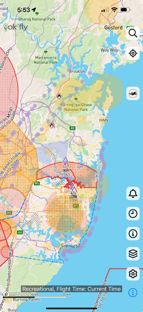
ok2flyアプリの制限飛行区域と安全情報を示す詳細なドローン空域マップ
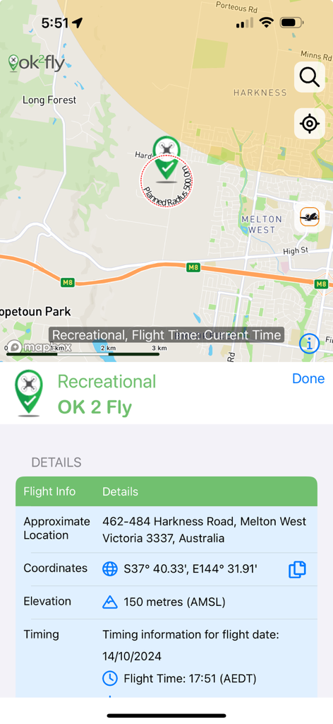
マップとレクリエーションドローン飛行計画の詳細を示すok2flyアプリのスクリーンショット。
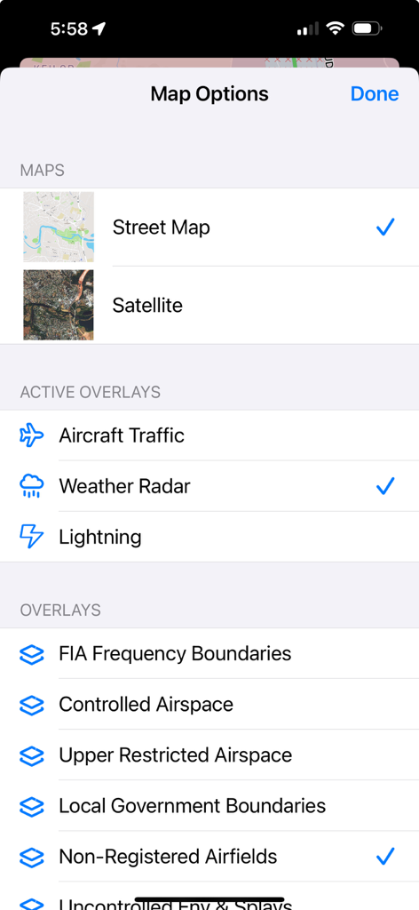
ok2flyアプリのマップ設定画面。ストリートマップ、衛星ビュー、気象レーダーや管制空域などの航空オーバーレイのオプションが表示されます。
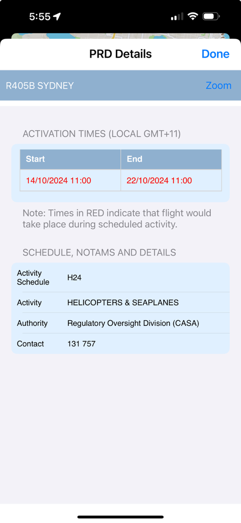
ok2flyアプリがシドニーのPRD詳細を表示。有効時間とヘリコプター活動スケジュールが含まれます。
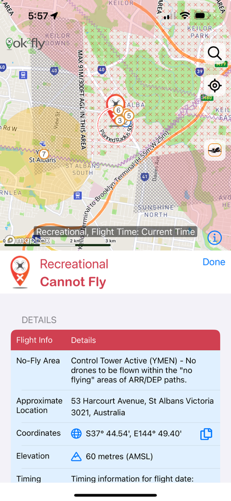
オーストラリアの活動中の管制塔によるドローン飛行禁止区域を示すok2flyアプリのスクリーンショット
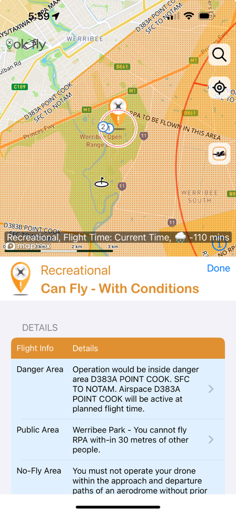
レクリエーションパイロット向けのドローン飛行安全条件とマップを示すok2flyアプリのスクリーンショット
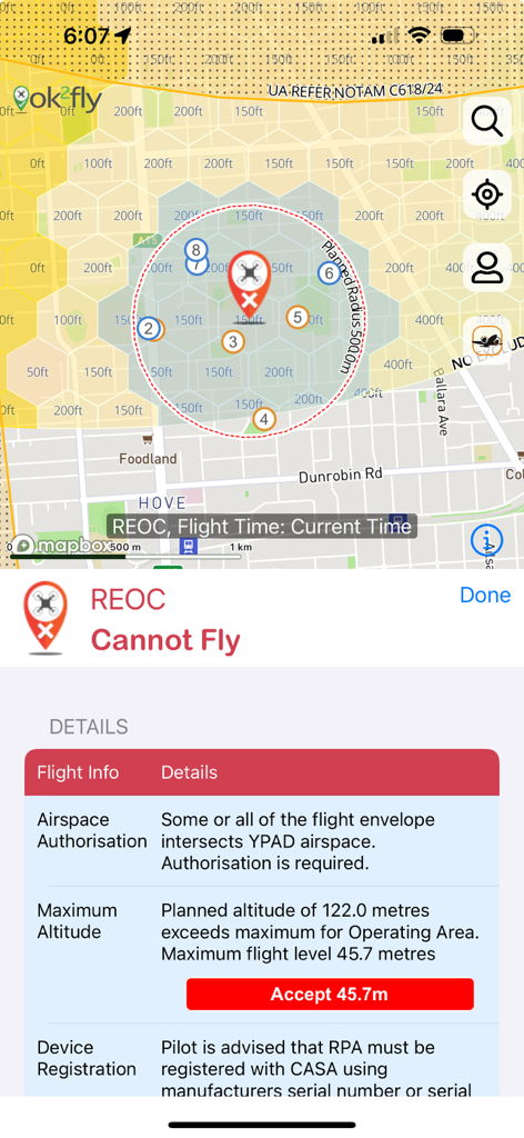
REOCパイロット向けの制限ドローン飛行区域マップと詳細な安全警告を表示するok2flyアプリのスクリーンショット。
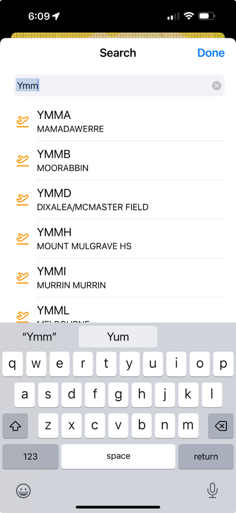
ok2flyアプリの検索画面。オーストラリアの空港コードと名前のリストが表示されます。
説明
Download
類似アプリ
同じカテゴリのトップランクアプリ

Google Maps
Google LLC

Waze Navigation & Live Traffic
waze

AMap Global
AutoNavi Information Technology Co. Ltd.

百度地图-路线规划,出行必备
Beijing Baidu Netcom Science & Technology Co.,Ltd

Moovit: Bus & Transit Tracker
Moovit App Global LTD

Transit • Subway & Bus Times
9280-0366 Quebec inc.

ParkMobile: Park. Pay. Go.
Parkmobile USA, Inc

腾讯地图-路线规划,导航地铁打车出行
Shenzhen Tencent Computer Systems Company Limited

Île-de-France Mobilités
Ile de France Mobilites
このページはアプリまたはその開発者の公式ページではなく、情報提供および論評を目的として作成された独立した編集出版物です。明示的に別段の記載がない限り、アプリおよびその開発者は、MWM、Apple、Google Play、アプリのパブリッシャー、またはアプリの開発者と提携、承認、後援、認可、またはその他の公式的な関係はなく、このページのいかなる内容も、アプリがMWMのサービスを使用して開発されたことを意味するものではありません。すべての商標、ロゴ、スクリーンショット、その他のコンテンツはそれぞれの所有者の財産です。