このページはアプリまたはその開発者の公式ページではなく、情報提供および論評を目的として作成された独立した編集出版物です。明示的に別段の記載がない限り、アプリおよびその開発者は、MWM、Apple、Google Play、アプリのパブリッシャー、またはアプリの開発者と提携、承認、後援、認可、またはその他の公式的な関係はなく、このページのいかなる内容も、アプリがMWMのサービスを使用して開発されたことを意味するものではありません。すべての商標、ロゴ、スクリーンショット、その他のコンテンツはそれぞれの所有者の財産です。

Relief Maps : backcountry gps
PCTからロッキー山脈まで、プロ品質のオフラインUSGSマップ、雪崩斜面分析、スキー、登山、パラグライダー向けの専門ツールで、すべてのピークを征服しましょう。
ダウンロード
106K+ユーザー評価
評価数
900開発元
カテゴリ
Navigation対応言語
2最新バージョン
2.5.1サイズ
196.9 MBリリース日
2019年1月20日テクニカルな探検家のために設計
PCTのロングトレイルを計画している場合でも、リスクの高いスキーツアーを計画している場合でも、Relief Mapsは3Dデータとオフラインでの信頼性を提供し、安全に限界を押し広げることができます。
没入感のある3D地形分析
高解像度の3DレンダリングされたUSGS topoマップでルートを視覚化し、トレイルに出る前に正確な地形を理解しましょう。
ミッションクリティカルなオフラインマップ
奥地で使用するために無制限のマップレイヤーをダウンロードしましょう。セルサービスやデータなしで完璧に機能するGPSナビゲーションで、現在地を把握しましょう。
以下のスクリーンショットと説明は、アプリの公式ストアリスティングから直接取得されたものであり、アプリ開発者の所有物です。
アプリストア
スクリーンショット
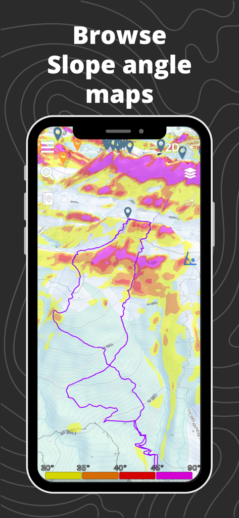
Relief Mapsモバイルアプリが、バックカントリーの安全のために追跡されたGPSルートを備えた3D斜面角度マップを表示しています
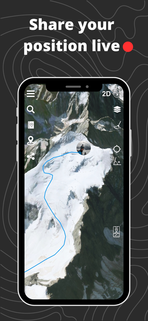
Relief Mapsアプリインターフェースが、青いルートパスとライブ位置インジケーターを備えた3D山岳地形を表示しています。
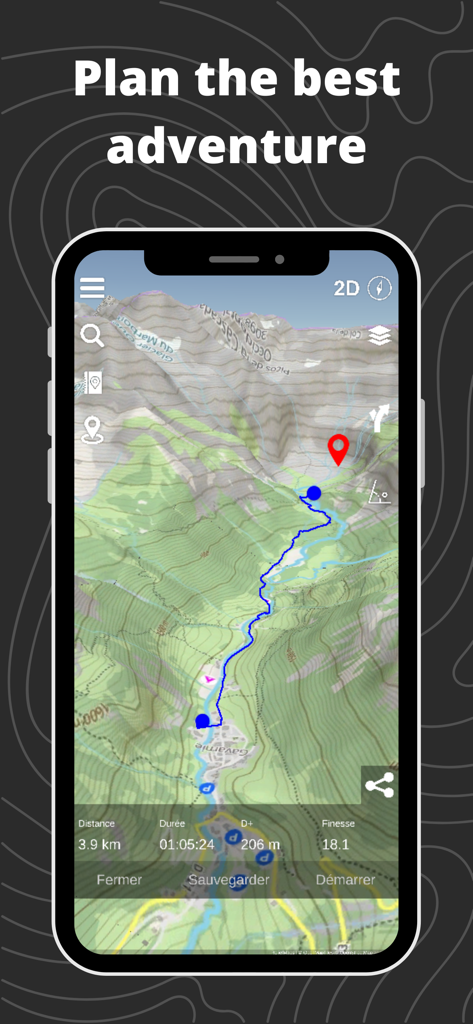
Relief Mapsアプリが、3D地形図と計画されたバックカントリールートを表示しています
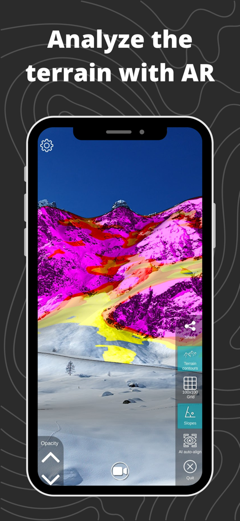
バックカントリーナビゲーションのための山の斜面勾配の拡張現実ビュー。
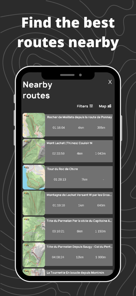
Relief Mapsアプリインターフェースが、テクニカルデータと地形図のサムネイルを備えた近くのバックカントリールートのリストを表示しています。
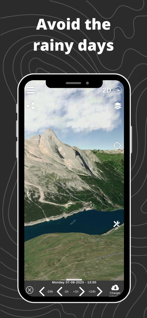
スマートフォンの3D地形図に、バックカントリー旅行中の雨の日を避けるための気象予報タイムラインが表示されています。
説明
Download
類似アプリ
似た機能とユーザー体験を持つアプリ

Saki - Connect & Share
潇泳 庄

Gaggle Paragliding, Ultralight
Viszen Pty Ltd

AvTraffic
Tailwind Software

Paragliding Tracker: Wingman
iSolid SPRL

Skida: Alpine Adventures
Mountainsnow AS

RealityMaps 3D tour planner
3D RealityMaps GmbH

Spot Assist Skydiving Tool
Andrey Kan

Flyskyhy
Rene Dekker

iGlide Advanced
Logic Design
このページはアプリまたはその開発者の公式ページではなく、情報提供および論評を目的として作成された独立した編集出版物です。明示的に別段の記載がない限り、アプリおよびその開発者は、MWM、Apple、Google Play、アプリのパブリッシャー、またはアプリの開発者と提携、承認、後援、認可、またはその他の公式的な関係はなく、このページのいかなる内容も、アプリがMWMのサービスを使用して開発されたことを意味するものではありません。すべての商標、ロゴ、スクリーンショット、その他のコンテンツはそれぞれの所有者の財産です。