このページはアプリまたはその開発者の公式ページではなく、情報提供および論評を目的として作成された独立した編集出版物です。明示的に別段の記載がない限り、アプリおよびその開発者は、MWM、Apple、Google Play、アプリのパブリッシャー、またはアプリの開発者と提携、承認、後援、認可、またはその他の公式的な関係はなく、このページのいかなる内容も、アプリがMWMのサービスを使用して開発されたことを意味するものではありません。すべての商標、ロゴ、スクリーンショット、その他のコンテンツはそれぞれの所有者の財産です。

RWIS
インフラ専門家向けに設計されたリアルタイムの道路表面の状態、早期着氷警報、ライブフィールドサービス追跡で、意思決定を強化します。
ダウンロード
23K+ユーザー評価
評価数
0開発元
カテゴリ
Weather対応言語
11最新バージョン
4.1.1サイズ
34.0 MBリリース日
2014年7月25日ポケットの中の運用コマンド
インフラ専門家のために構築されたリアルタイムの道路状況、ライブフリート追跡、ハイパーローカルセンサーデータで、冬の気象への対応を合理化します。
ハイパーローカル道路インテリジェンス
必要に応じてのみ道路を処理するために、精密センサーデータで道路表面温度、水深、着氷リスクを監視します。
リアルタイムフリート調整
インタラクティブマップ上でアクティブな車両と色分けされた介入ルートを追跡し、完全なカバレッジと運用の透明性を確保します。
以下のスクリーンショットと説明は、アプリの公式ストアリスティングから直接取得されたものであり、アプリ開発者の所有物です。
アプリストア
スクリーンショット
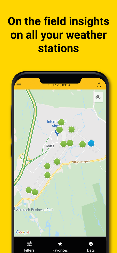
RWISアプリインターフェイスが空港マップ上の気象観測所の場所を表示しています。

RWISモバイルアプリインターフェイスがインタラクティブな都市マップ上にリアルタイム車両ルート追跡を表示しています。

RWISアプリマップビューが、bMoves介入のための色分けされた車両ルートとリアルタイムフリート追跡を表示しています。
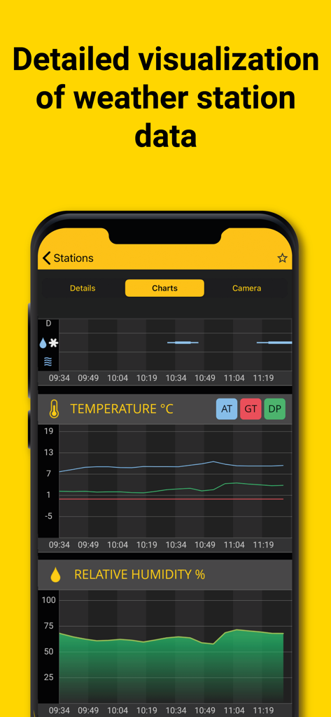
RWISアプリが道路気象観測所の監視のためのリアルタイム温度および相対湿度グラフを表示しています。
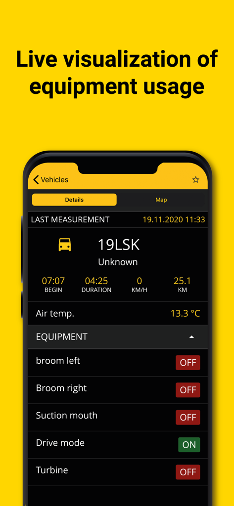
RWISアプリダッシュボードが、道路メンテナンスのためのライブ機器ステータスと車両データを表示しています。
説明
Download
類似アプリ
同じカテゴリのトップランクアプリ

墨迹天气-MojiWeather
Beijing MojiFengyun Technology Co.,Ltd.

The Weather Channel - Radar
The Weather Channel

Windy.com
Windyty, SE

天气预报-精准15日天气预报
Chongqing Caochen Technology Co., Ltd.

My Aurora Forecast & Alerts
JRustonApps B.V.

AccuWeather: Weather Forecast
AccuWeather International, Inc.

Weather & Radar - Storm radar
WetterOnline - Meteorologische Dienstleistungen GmbH

天气通
Weibo Internet Technology (China) Co.Ltd.

The Thermometer -Digital-
Vida Apps Incorporated
このページはアプリまたはその開発者の公式ページではなく、情報提供および論評を目的として作成された独立した編集出版物です。明示的に別段の記載がない限り、アプリおよびその開発者は、MWM、Apple、Google Play、アプリのパブリッシャー、またはアプリの開発者と提携、承認、後援、認可、またはその他の公式的な関係はなく、このページのいかなる内容も、アプリがMWMのサービスを使用して開発されたことを意味するものではありません。すべての商標、ロゴ、スクリーンショット、その他のコンテンツはそれぞれの所有者の財産です。