このページはアプリまたはその開発者の公式ページではなく、情報提供および論評を目的として作成された独立した編集出版物です。明示的に別段の記載がない限り、アプリおよびその開発者は、MWM、Apple、Google Play、アプリのパブリッシャー、またはアプリの開発者と提携、承認、後援、認可、またはその他の公式的な関係はなく、このページのいかなる内容も、アプリがMWMのサービスを使用して開発されたことを意味するものではありません。すべての商標、ロゴ、スクリーンショット、その他のコンテンツはそれぞれの所有者の財産です。

Satellite Tracker - Sky Map
ISS、気象衛星コンステレーション、通信衛星をプロレベルの精度で監視。アマチュア無線オペレーターでも宇宙愛好家でも、オフラインでも正確な軌道データとインタラクティブマップを入手できます。
ダウンロード
5K+ユーザー評価
評価数
0開発元
カテゴリ
Reference対応言語
1最新バージョン
2.1サイズ
27.9 MBリリース日
2022年6月8日あなたの頭上の空をマスターする
デバイスをプロレベルの追跡ステーションに変えましょう。ISS、通信ネットワーク、科学衛星をリアルタイムの精度と詳細な技術情報で監視します。
ライブリアルタイム追跡
ISSと数千の現役衛星を、精密な軌道経路とインタラクティブな高解像度マップで世界中で追跡します。
包括的なデータインサイト
技術仕様、打ち上げ日、ミッション目標にアクセス。STEM教育、専門家、アマチュア無線愛好家に最適です。
以下のスクリーンショットと説明は、アプリの公式ストアリスティングから直接取得されたものであり、アプリ開発者の所有物です。
アプリストア
スクリーンショット
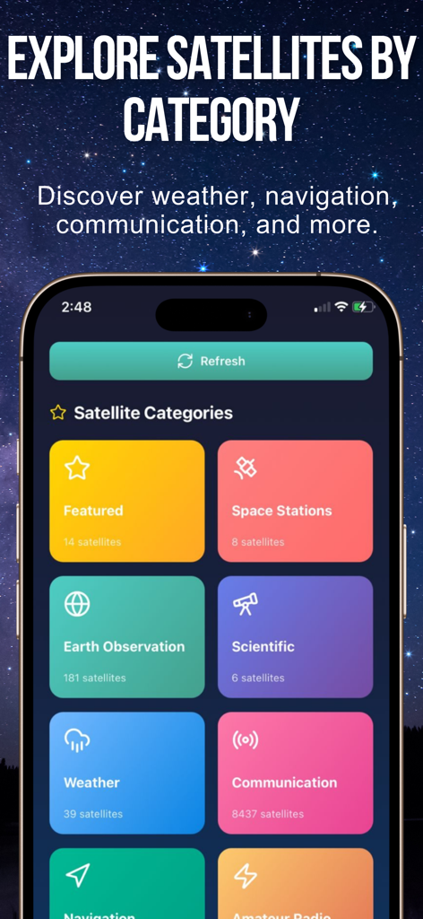
星空を背景に、宇宙ステーションや気象衛星などのカテゴリ別の衛星グループを示す衛星トラッカーアプリのインターフェイス
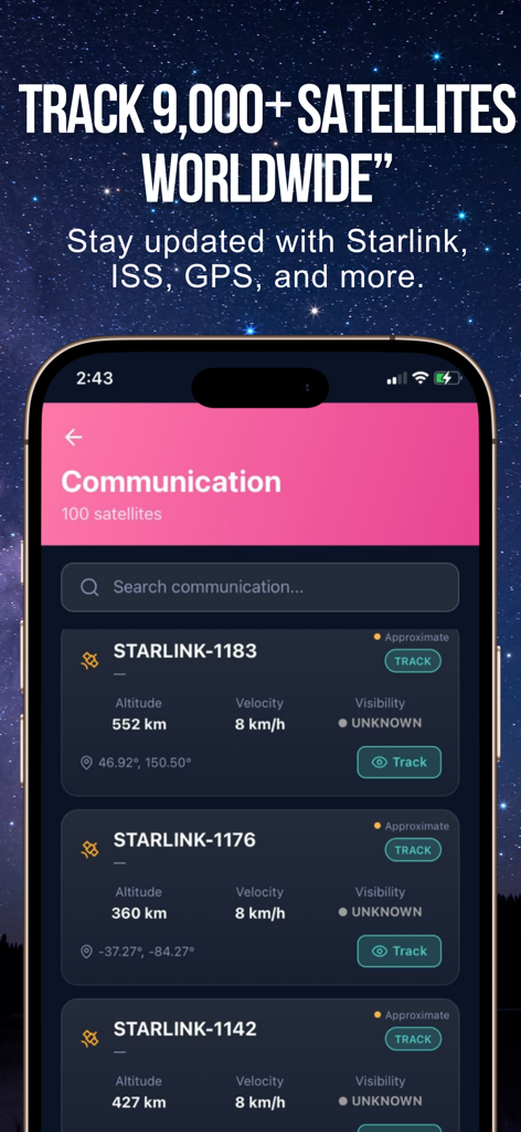
高度と速度のデータとともに、追跡中のStarlink衛星のリストを示す衛星トラッカーアプリのインターフェイス
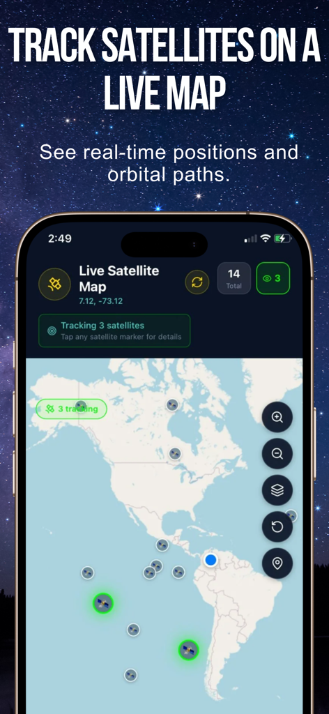
世界地図上にリアルタイムの軌道位置と経路を示すライブ衛星マップ
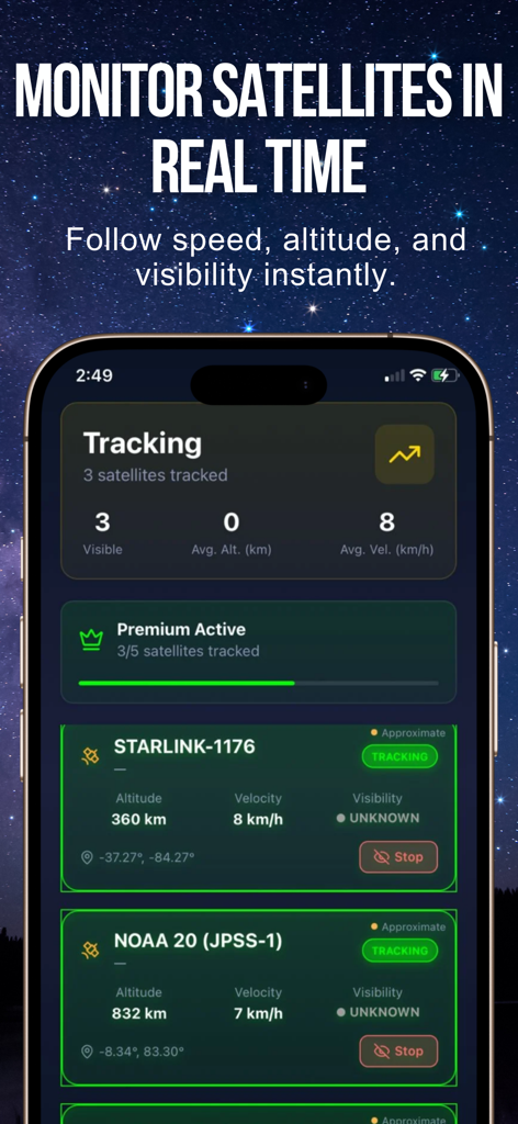
StarlinkとNOAA衛星の高度と速度を示すリアルタイム衛星追跡ダッシュボード
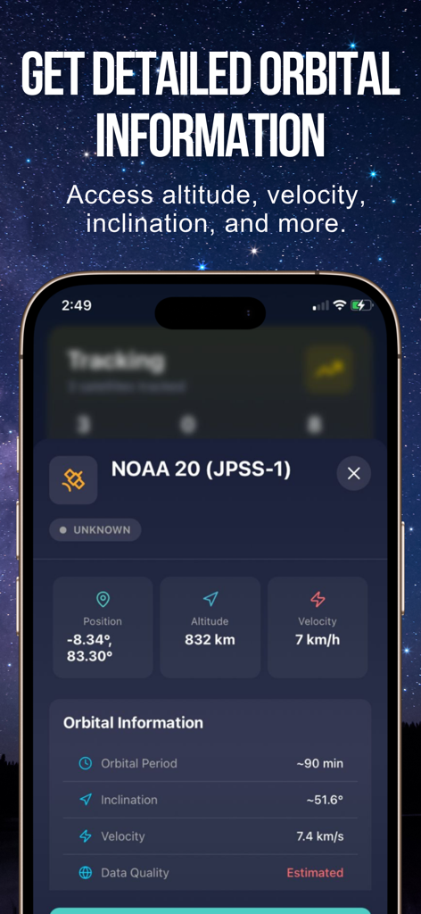
高度と速度を含むNOAA 20衛星の詳細な軌道情報を示すモバイル画面
説明
Download
類似アプリ
同じカテゴリのトップランクアプリ

Google Translate
Google LLC

火箭沙盒
P2E CO., LTD.

Bible
Life.Church

Bible Chat: Daily Devotional
BookVitals APP SRL

Youdao Dictionary
Beijing NetEase Youdao Computer System Co.,Ltd

Translate Now - AI Translator
AIR APPS SYSTEMS, UNIPESSOAL, LDA

Naver Papago - AI Translator
NAVER Corp.

ΗiΤV - Endless Movies & Shows
学 张

Live Translator - AI Translate
DigitalSail (HK) Limited
このページはアプリまたはその開発者の公式ページではなく、情報提供および論評を目的として作成された独立した編集出版物です。明示的に別段の記載がない限り、アプリおよびその開発者は、MWM、Apple、Google Play、アプリのパブリッシャー、またはアプリの開発者と提携、承認、後援、認可、またはその他の公式的な関係はなく、このページのいかなる内容も、アプリがMWMのサービスを使用して開発されたことを意味するものではありません。すべての商標、ロゴ、スクリーンショット、その他のコンテンツはそれぞれの所有者の財産です。