このページはアプリまたはその開発者の公式ページではなく、情報提供および論評を目的として作成された独立した編集出版物です。明示的に別段の記載がない限り、アプリおよびその開発者は、MWM、Apple、Google Play、アプリのパブリッシャー、またはアプリの開発者と提携、承認、後援、認可、またはその他の公式的な関係はなく、このページのいかなる内容も、アプリがMWMのサービスを使用して開発されたことを意味するものではありません。すべての商標、ロゴ、スクリーンショット、その他のコンテンツはそれぞれの所有者の財産です。

Singapore MRT Map Route(Pro)
ビジネス旅行者や観光客に最適な、広告なしの究極のコンパニオン。最速のルート、所要時間見積もり、最新のバイリンガルマップデータをわずか1秒で取得できます。
ダウンロード
84K+ユーザー評価
評価数
500開発元
カテゴリ
Navigation対応言語
1最新バージョン
2.9.7サイズ
181.2 MBリリース日
2011年11月2日グローバル旅行者のための精密ナビゲーション
MRTネットワーク全体で最速のルートを提供する、広告なしのプログレードツールキットでシンガポールでの時間を最大限に活用しましょう。
1秒でルート最適化
駅間の最も効率的な経路を瞬時に計算します。重要なビジネス会議やタイトな旅行スケジュールに最適です。
最新のシステムマップ
新しいトムソン・イーストコースト線(TEL)や主要な乗り換え接続を含む最新のアップデートで、自信を持ってナビゲートしてください。
以下のスクリーンショットと説明は、アプリの公式ストアリスティングから直接取得されたものであり、アプリ開発者の所有物です。
アプリストア
スクリーンショット
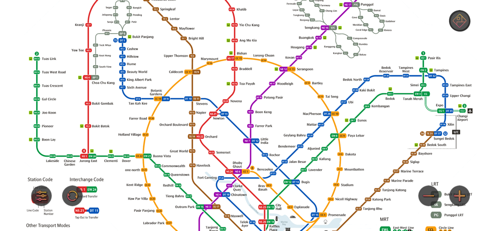
シンガポールMRTとLRTの地下鉄マップの完全なデジタルレイアウト。乗り換え路線と駅の接続を示しています。
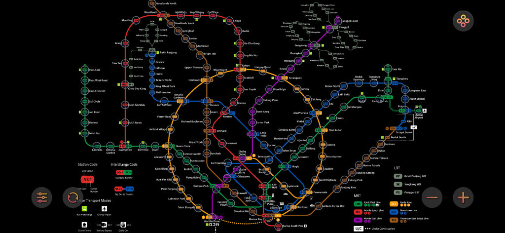
シンガポールMRTとLRTの乗り換えシステムの詳細なカラーコードマップ。
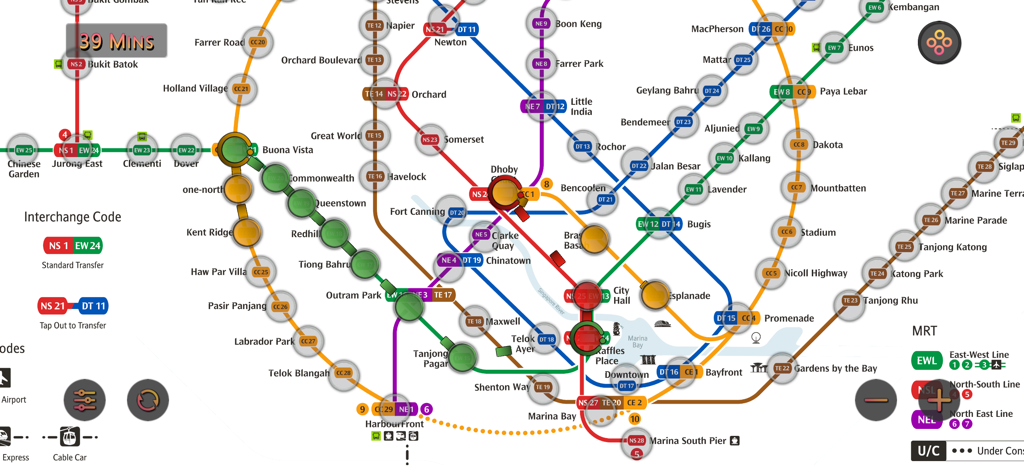
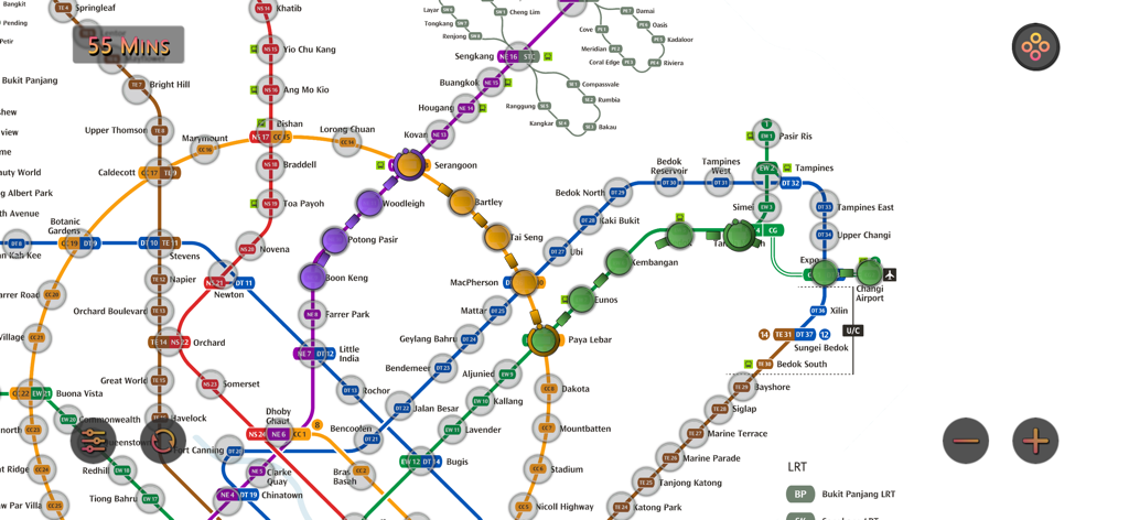
さまざまなMRT路線とルートの所要時間見積もりを示す、シンガポールMRTマップルート(Pro)の詳細な地下鉄マップ。
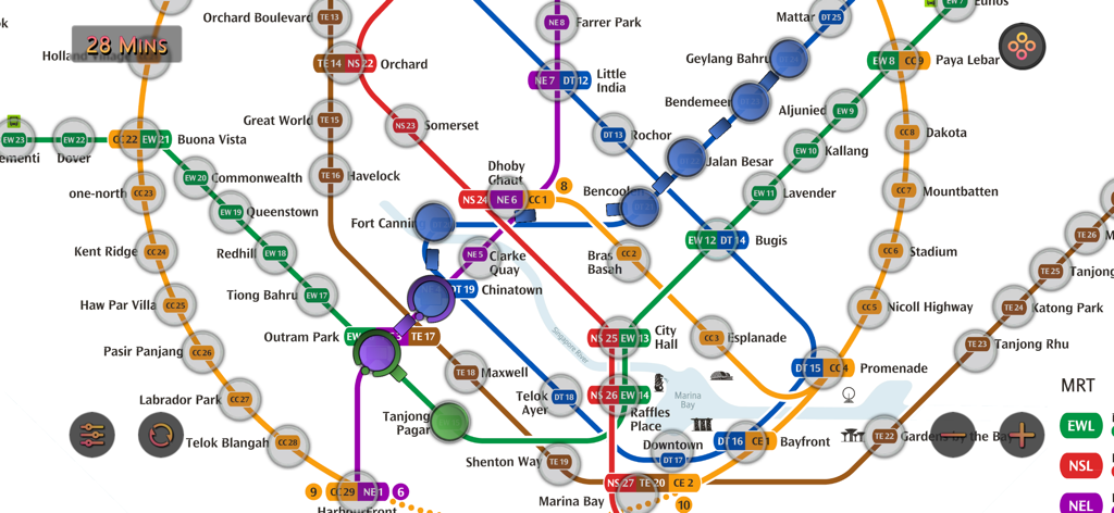
ルートパスと所要時間インジケーターの詳細なシンガポールMRT地下鉄マップ。
ルート計算と所要時間見積もりを示す、詳細なシンガポールMRT地下鉄マップインターフェース
説明
Download
類似アプリ
同じカテゴリのトップランクアプリ

Google Maps
Google LLC

Waze Navigation & Live Traffic
waze

AMap Global
AutoNavi Information Technology Co. Ltd.

百度地图-路线规划,出行必备
Beijing Baidu Netcom Science & Technology Co.,Ltd

Moovit: Bus & Transit Tracker
Moovit App Global LTD

Transit • Subway & Bus Times
9280-0366 Quebec inc.

ParkMobile: Park. Pay. Go.
Parkmobile USA, Inc

腾讯地图-路线规划,导航地铁打车出行
Shenzhen Tencent Computer Systems Company Limited

Île-de-France Mobilités
Ile de France Mobilites
このページはアプリまたはその開発者の公式ページではなく、情報提供および論評を目的として作成された独立した編集出版物です。明示的に別段の記載がない限り、アプリおよびその開発者は、MWM、Apple、Google Play、アプリのパブリッシャー、またはアプリの開発者と提携、承認、後援、認可、またはその他の公式的な関係はなく、このページのいかなる内容も、アプリがMWMのサービスを使用して開発されたことを意味するものではありません。すべての商標、ロゴ、スクリーンショット、その他のコンテンツはそれぞれの所有者の財産です。