このページはアプリまたはその開発者の公式ページではなく、情報提供および論評を目的として作成された独立した編集出版物です。明示的に別段の記載がない限り、アプリおよびその開発者は、MWM、Apple、Google Play、アプリのパブリッシャー、またはアプリの開発者と提携、承認、後援、認可、またはその他の公式的な関係はなく、このページのいかなる内容も、アプリがMWMのサービスを使用して開発されたことを意味するものではありません。すべての商標、ロゴ、スクリーンショット、その他のコンテンツはそれぞれの所有者の財産です。

ダウンロード
500k+ユーザー評価
評価数
7.1K開発元
カテゴリ
Navigation対応言語
1最新バージョン
8.1.73サイズ
147.5 MBリリース日
2022年4月18日ベトナムの不動産市場における戦略的意思決定を支援する主要機能の評価
Thongtin.land- アプリケーションの主要機能分析
包括的土地利用計画データ
投資家、開発者、法律専門家が土地の利用計画、建設規制、法的な決定を含む詳細な情報を入手でき、将来の土地開発や投資戦略を立てる上で不可欠です。
多様な形式での計画情報視覚化
ユーザーは様々な方法(地番、区画境界、Googleマップ座標、VN-2000座標)で計画情報を視覚的に確認でき、土地の正確な位置特定と計画状況の把握を容易にします。
最新の土地・不動産評価情報
ユーザーは最新の土地価格と不動産価格情報を取得でき、市場評価、投資機会の特定、または売買交渉において情報に基づいた意思決定を支援します。
合併後情報検索機能
企業合併後の土地関連情報や所有権の変更などを確認できるため、M&Aに関連する不動産取引や法務デューデリジェンスにおいて重要です。
よくある質問
について知っておくべきこと Thongtin.land-
What types of planning maps does Thongtin.land- offer?
Thongtin.land- provides land use plans for 2026 and 2030, detailed construction plans, and cadastral maps. These plans include accompanying official legal decisions.
Can Thongtin.land- display information about land use after mergers?
Yes, Thongtin.land- allows users to look up planning information for areas that have undergone mergers. The app features a dedicated interface for accessing consolidated post-merger data.
How can users view planning maps within the Thongtin.land- app?
Thongtin.land- offers multiple viewing methods for planning maps. Users can view maps by land parcel (tờ thửa), boundary corner (góc ranh), Google Maps coordinates, and VN-2000 coordinates.
Does Thongtin.land- provide current land and real estate prices?
Yes, Thongtin.land- displays the latest land and real estate prices for 2026. Users can view state-adjusted land prices for various locations directly within the app.
Does the Thongtin.land- app include an AI assistant for planning queries?
Yes, Thongtin.land- features an intelligent AI planning assistant named LAN. This assistant helps users with various queries related to planning and land information.
Can users find detailed information about specific land parcels in Thongtin.land-?
Yes, Thongtin.land- provides clear, detailed information for land parcels. This includes data such as area, precise location, coordinates, and specific land use codes like SKC and CLN.
Are legal documents included with the planning maps in Thongtin.land-?
Yes, Thongtin.land- ensures transparent legality by providing legal decisions that accompany the planning maps. Users can view official documents like People's Committee Decisions directly.
Does Thongtin.land- have tools for measuring land parcels?
Yes, Thongtin.land- includes precise measurement tools for land parcels. Users can accurately determine the length of boundaries and calculate the area of specific sections on the map.
Does Thongtin.land- support real estate buying, selling, or renting needs?
Yes, Thongtin.land- aggregates demands for buying, selling, and renting real estate. This feature helps users connect with relevant real estate opportunities and needs.
Is there a cost associated with viewing planning maps in Thongtin.land-?
Some planning maps in Thongtin.land- are free to view, such as administrative boundary maps. Other specialized plans may incur a small fee, typically indicated as "2 land / lượt xem" or "5 land / lượt xem".
以下のスクリーンショットと説明は、アプリの公式ストアリスティングから直接取得されたものであり、アプリ開発者の所有物です。
アプリストア
スクリーンショット
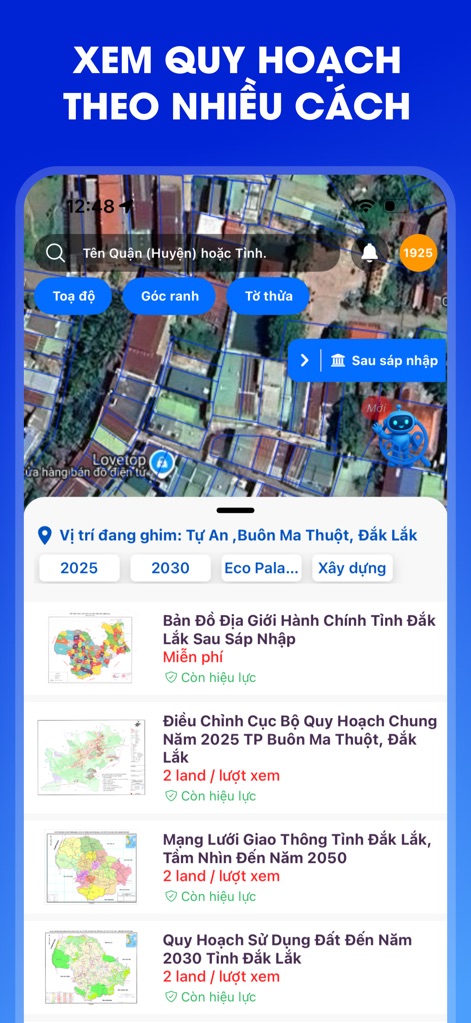
この画面では、座標、境界、または地番といった多様な検索オプションを使用して、ユーザーが正確な土地情報を迅速に特定できることを示しています。例えば、ダクラク省バンメトート市トゥーアンの場所を特定し、関連する土地利用計画を表示しています。
柔軟な検索オプション

本アプリの豊富な地図コレクションは、ユーザーがハノイ市のような特定の地域や計画タイプに基づいて詳細な地図を検索できることを示しています。例えば、合併後のハノイ市の行政境界図や2045年までのハノイ首都圏の総合計画がリストされています。
多様な地図コレクション
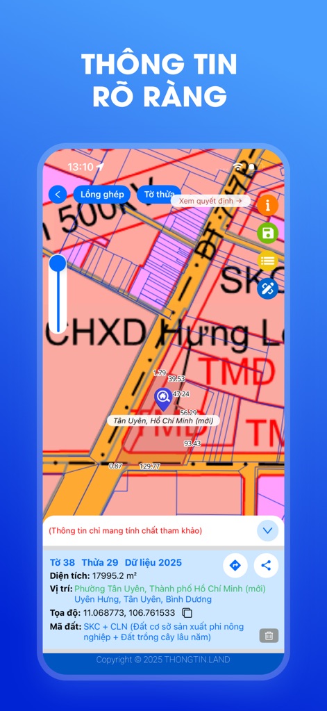
この画面は、土地の詳細な情報と区画データを明確に表示する機能を示しています。ユーザーは区画番号38、地番29の土地の面積が17995.2m²であることを確認し、その座標とホーチミン市内の正確な位置を把握できます。
明確な土地詳細
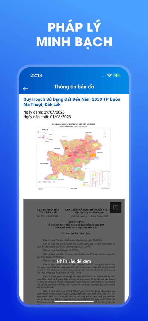
ユーザーは、この画面を通じて土地利用計画に関する公式決定書と法的文書に直接アクセスできます。スクリーンショットは、ダクラク省バンメトート市の2030年までの土地利用計画の概要図と、関連するベトナム政府の法令文を表示しています。
透明な法的文書
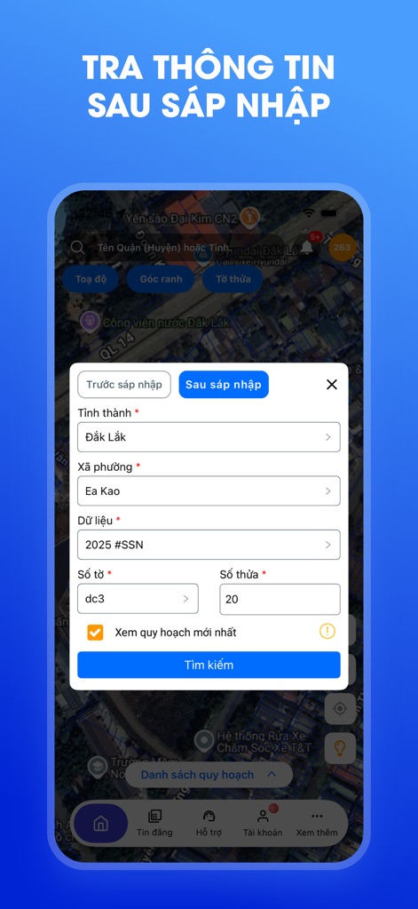
この機能は、行政区域の合併後の土地情報を効率的に検索することを可能にします。ユーザーはダクラク省の特定のコミューンや地番、区画番号を入力して、最新の計画情報を簡単に照会できます。
合併後の情報検索
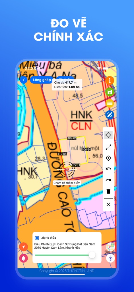
本アプリは、ユーザーが地図上で正確な距離と面積を測定できる機能を提供します。スクリーンショットでは、特定の地番内の境界線の長さが417.7m、面積が1.09ヘクタールとして計算され表示されています。
正確な土地測定
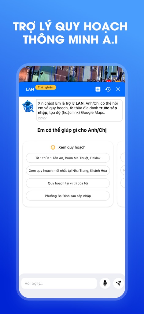
アプリに搭載されたAIアシスタント「LAN」は、ユーザーの土地情報検索をサポートします。この画面では、特定地域の土地計画の照会や、合併後の行政区画に関する情報提供といった複数のクイックアクションオプションが提示されています。
AIアシスタントが支援
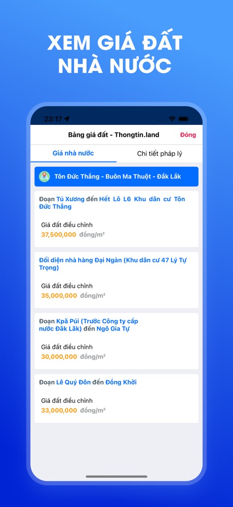
ユーザーは、この画面でベトナム政府が定める最新の土地価格を簡単に確認できます。表示されているのは、ダクラク省バンメトート市のトン・ドゥック・タン通りにおける1m²あたり37,500,000ドンという調整済み土地価格を含む、複数の地域の価格情報です。
最新の土地価格
説明
Download
類似アプリ
似た機能とユーザー体験を持つアプリ

моЄ - дані про твої ділянки
Feodal TOV

Landeed – Land Records & Bills
JOHN SALT PRIVATE LIMITED

Q.hoạch VN
Nguyen Khac Trong

Sentuh Tanahku
Kementerian Agraria dan Tata Ruang - Badan Pertanahan Nasional

RER | السجل العقاري
National Real Estate Registration Services Co.

Guland bản đồ quy hoạch VN
Duong Le Dai

Saudi Real Estate Market
Ministry of Justice Kingdom of Saudi Arabia

QH TP. HCM
phuong pham

TKGM Parsel Sorgu
Tapu ve Kadastro Genel Mudurlugu
このページはアプリまたはその開発者の公式ページではなく、情報提供および論評を目的として作成された独立した編集出版物です。明示的に別段の記載がない限り、アプリおよびその開発者は、MWM、Apple、Google Play、アプリのパブリッシャー、またはアプリの開発者と提携、承認、後援、認可、またはその他の公式的な関係はなく、このページのいかなる内容も、アプリがMWMのサービスを使用して開発されたことを意味するものではありません。すべての商標、ロゴ、スクリーンショット、その他のコンテンツはそれぞれの所有者の財産です。