このページはアプリまたはその開発者の公式ページではなく、情報提供および論評を目的として作成された独立した編集出版物です。明示的に別段の記載がない限り、アプリおよびその開発者は、MWM、Apple、Google Play、アプリのパブリッシャー、またはアプリの開発者と提携、承認、後援、認可、またはその他の公式的な関係はなく、このページのいかなる内容も、アプリがMWMのサービスを使用して開発されたことを意味するものではありません。すべての商標、ロゴ、スクリーンショット、その他のコンテンツはそれぞれの所有者の財産です。

Tracker - for dogs and outdoor
リアルタイムの犬追跡、高精度の地形図、戦術的なグループ調整で、より安全で成功した冒険のために地形をマスターしましょう。
ダウンロード
151K+ユーザー評価
評価数
700開発元
カテゴリ
Navigation対応言語
3最新バージョン
7.7.14サイズ
82.7 MBリリース日
2020年6月1日現代のアウトドアマンのための精密ツール
バックカントリーのために設計されたリアルタイムの犬追跡、高度な地形マッピング、シームレスなグループ調整で、あなたの環境をマスターしましょう。
リアルタイム犬追跡
最も価値のあるパートナーを見失うことはありません。高詳細マップ上で犬の動きをライブで追跡し、その安全とあなたの成功を確保します。
戦術的グループ調整
ハンティングパーティーやハイキンググループ全体を同期します。ウェイポイントを共有し、メンバーの場所をリアルタイムで表示し、フィールドでシームレスに通信します。
よくある質問
について知っておくべきこと Tracker - for dogs and outdoor
Tracker - for dogs and outdoorアプリとは何ですか?
Trackerアプリは、アウトドア愛好家向けのライブトラッキングおよびナビゲーションツールです。高画質の地形図や衛星地図上で、ユーザー、犬、友人をリアルタイムで追跡し、ハイキングや狩猟などのアクティビティをサポートします。
Tracker - for dogs and outdoorアプリは無料で利用できますか?
はい、Trackerアプリには無料版があります。自分の位置を追跡したり、匿名の安全機能を使用して他のユーザーを確認したり、アウトドアアドベンチャーのために地図のマーキングを保存したりできます。
Trackerアプリの無料版の主な機能は何ですか?
無料版のTrackerアプリは、地形図/衛星地図上であなたの位置を追跡し、近くのユーザーを表示する匿名の安全機能が含まれています。また、地図上にマーキングを追加して保存することもできます。
Trackerアプリはリアルタイムで犬の追跡を提供しますか?
はい、Trackerアプリのフルバージョンでは、高画質の地図上で犬の位置をリアルタイムで追跡できます。強化された監視のために、高度なドッグセーフティ機能が統合されています。
Trackerアプリはナビゲーションにどのような地図を使用しますか?
Trackerアプリは、最新の地形図と衛星地図の優れたセレクションを利用しています。これらには、特定のヨーロッパ諸国の高画質地図や、世界中の良質な地図が含まれます。
Trackerアプリで狩猟グループのメンバーを追跡できますか?
はい、Trackerアプリのフルバージョンでは、グループメンバーの位置をリアルタイムで追跡できます。また、効果的な共同作業のために、グループ内で地図のマーキングや犬の追跡を共有することもできます。
Trackerアプリの安全機能は、アウトドアの安全をどのように向上させますか?
Trackerアプリの安全機能は、匿名の他の近くのユーザーを地図上に表示することで安全性を向上させます。フルバージョンでは、他のユーザーからの犬やオオカミの観察情報も含まれるように拡張されています。
Trackerアプリを使用してオオカミの観察情報を報告することは可能ですか?
はい、Trackerアプリではユーザーがオオカミの観察情報を報告できます。この機能は地図インターフェイスを通じて利用でき、すべてのユーザーのためのオオカミ安全機能に貢献します。
Trackerアプリでマーキングに使用できる地図ツールは何ですか?
Trackerアプリは多用途な地図ツールを提供します。ユーザーは、POI(興味のある地点)を追加したり、線や領域を測定/マーキングしたり、コレクションを作成したり、外部レイヤーを追加したり、これらのマーキングを友人やグループと共有したりできます。
Trackerアプリはグループ向けのアプリ内コミュニケーションを提供しますか?
はい、Trackerアプリには組み込みのチャット機能があります。これにより、グループメンバーは効果的にコミュニケーションを取り、狩猟グループやアウトドアグループ内でリアルタイムの情報や決定を共有できます。
以下のスクリーンショットと説明は、アプリの公式ストアリスティングから直接取得されたものであり、アプリ開発者の所有物です。
アプリストア
スクリーンショット
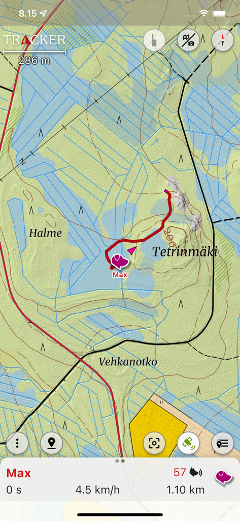
トラッカーアプリ内で、地形図上のトレイルを表示するリアルタイム犬追跡インターフェース
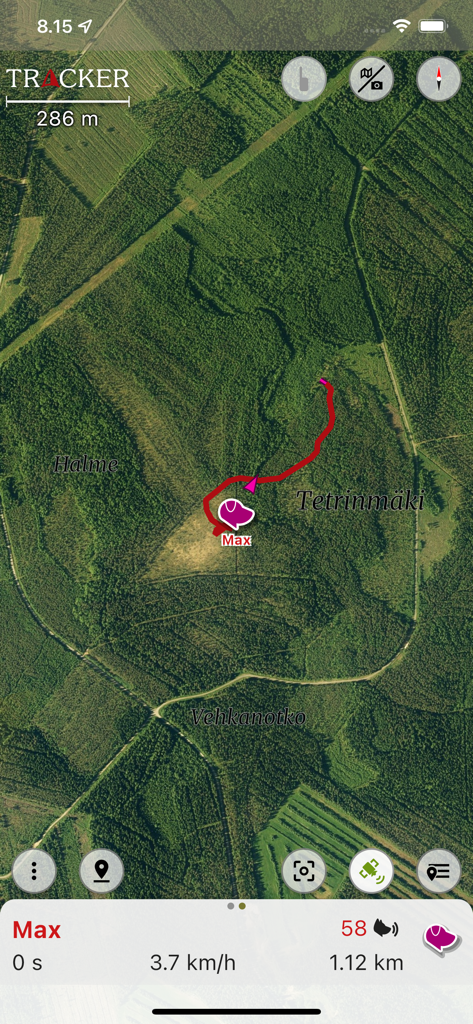
衛星マップ上にペットの位置を表示するリアルタイム犬追跡インターフェース
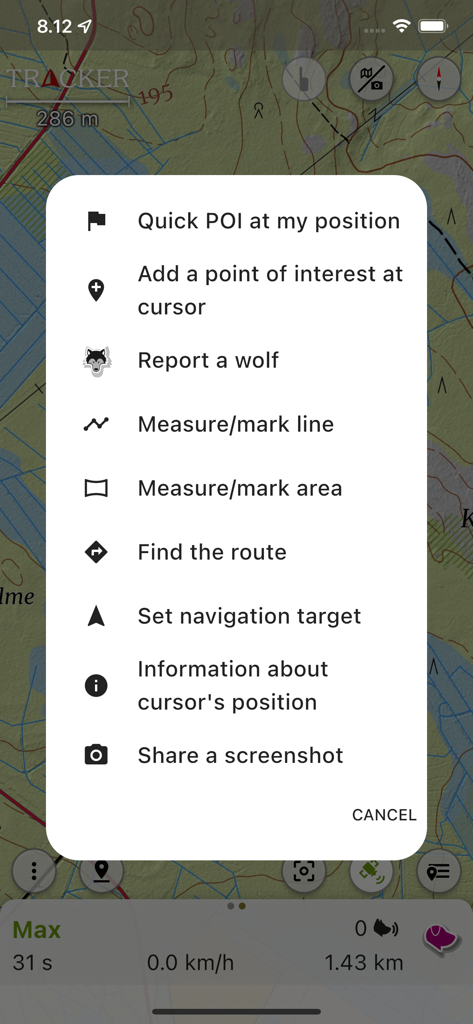
アウトドアナビゲーションとオオカミの目撃報告のオプションを示すトラッカーアプリのコンテキストメニュー
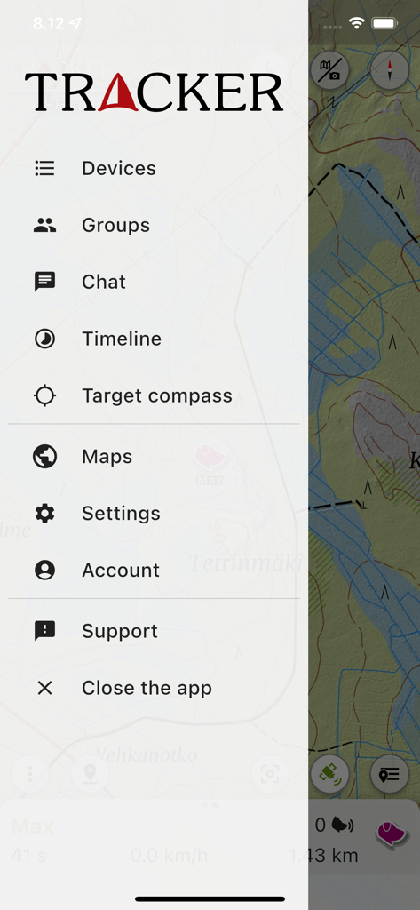
ナビゲーションと犬追跡オプションを示すトラッカーアプリのメインサイドメニュー
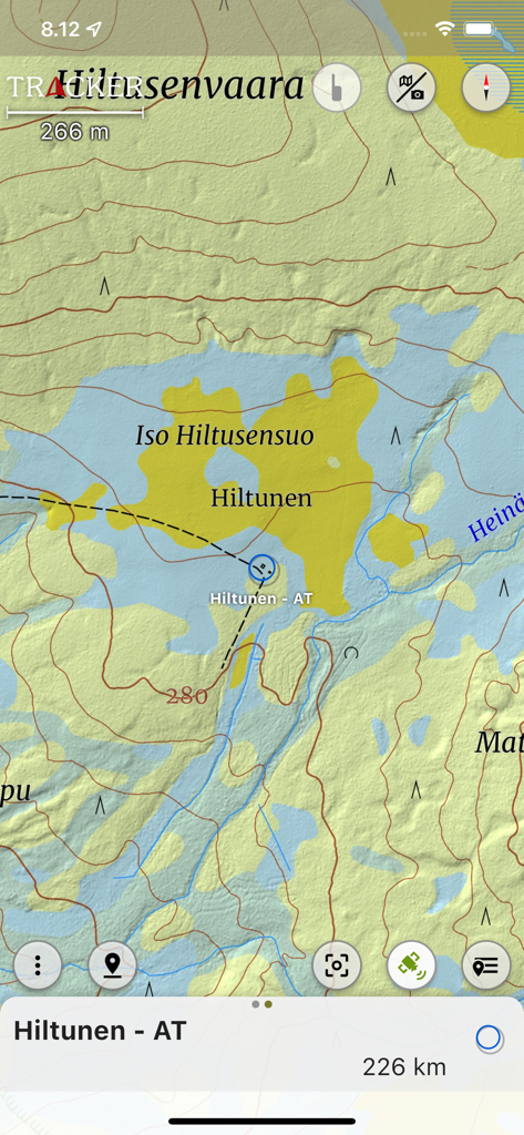
ハイキングやハンティングのための位置マーカー付きの詳細な地形図を表示するトラッカーアプリのインターフェース
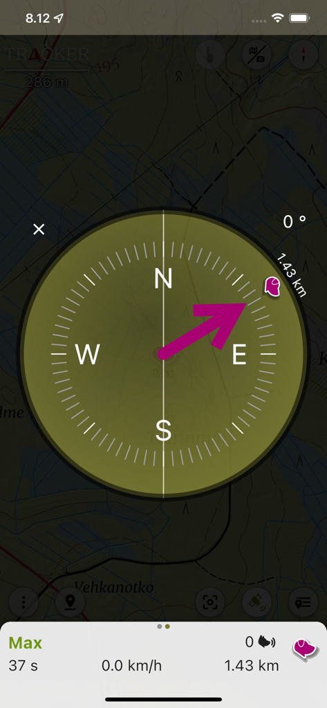
地形図上のリアルタイム犬追跡と距離を表示するコンパスナビゲーションインターフェース
説明
Download
類似アプリ
似た機能とユーザー体験を持つアプリ

Garmin Messenger™
Garmin International

Tractive GPS for Dogs and Cats
tractive GmbH

Fi - GPS Dog Tracker
Barking Labs Corp.

aprs.fi
GainIO Oy

SafeAnchor.Net
Barkin Takmaz

Anchor Alarm / Watch
w&h GmbH

FollowMee GPS Location Tracker
FollowMee LLC

Halo Collar
Protect Animals With Satellites, LLC

AeroVision7
Marshall Radio Telemetry
このページはアプリまたはその開発者の公式ページではなく、情報提供および論評を目的として作成された独立した編集出版物です。明示的に別段の記載がない限り、アプリおよびその開発者は、MWM、Apple、Google Play、アプリのパブリッシャー、またはアプリの開発者と提携、承認、後援、認可、またはその他の公式的な関係はなく、このページのいかなる内容も、アプリがMWMのサービスを使用して開発されたことを意味するものではありません。すべての商標、ロゴ、スクリーンショット、その他のコンテンツはそれぞれの所有者の財産です。