このページはアプリまたはその開発者の公式ページではなく、情報提供および論評を目的として作成された独立した編集出版物です。明示的に別段の記載がない限り、アプリおよびその開発者は、MWM、Apple、Google Play、アプリのパブリッシャー、またはアプリの開発者と提携、承認、後援、認可、またはその他の公式的な関係はなく、このページのいかなる内容も、アプリがMWMのサービスを使用して開発されたことを意味するものではありません。すべての商標、ロゴ、スクリーンショット、その他のコンテンツはそれぞれの所有者の財産です。

UTM Geo Map Y2Tech
お使いのデバイスをプロ仕様のハンドヘルドGPSに変えましょう。エンジニアや地質学者のために構築されたオフライン空間分析ツールで、高精度のUTM/MGRS座標を取得し、等高線を生成し、現場での杭打ちを実行します。
ダウンロード
5K+ユーザー評価
評価数
0開発元
カテゴリ
Navigation対応言語
6最新バージョン
1.0.11サイズ
21.3 MBリリース日
2025年10月28日ポケットに入るプロ仕様GIS&測量パワー
高精度座標追跡、空間分析、フィールドマッピングのためのプロ仕様ツールキットをチームに装備しましょう。高価なハンドヘルドGPSユニットの代替となるように設計されています。
プロ仕様のオフライン精度
携帯サービスのない遠隔地のオフグリッドでも、サブメートルの精度でUTM、MGRS、MSL標高データをキャプチャします。
高度な空間分析
バッファリング、オーバーレイ、杭打ちなどの複雑なGIS操作を直接現場で実行します。専門的な精度で面積と距離を計算します。
よくある質問
について知っておくべきこと UTM Geo Map Y2Tech
UTM Geo Map Y2Techとは何ですか?
UTM Geo Map Y2Techは、測量、地形、水深測量、GISのための無料のシンプルなアプリケーションです。座標、空間分析、測定のためのツールを提供し、さまざまな工学および地質分野に適しています。
UTM Geo Map Y2Techは無料のアプリケーションですか?
はい、UTM Geo Map Y2Techは無料のアプリケーションです。測量およびGISのための豊富な機能を提供します。MSL標高、等高線、標高プロファイルなどの一部の特定のモジュールは、購入が必要なプレミアム機能です。
インターネット接続なしでUTM Geo Map Y2Techを使用できますか?
はい、UTM Geo Map Y2TechにはオフラインGPSモジュールが含まれています。これにより、ユーザーはインターネット接続を必要とせずに、緯度経度、UTM、MGRS座標、および標高データを取得できます。
UTM Geo Map Y2Techで取得できる座標の種類は何ですか?
UTM Geo Map Y2Techは、EPSGコードを使用して、緯度経度、UTM、MGRS、およびその他の座標参照システムを取得します。また、MSL標高(プレミアム)を提供し、包括的なデータでポイントをプロットできます。
UTM Geo Map Y2Techは面積と距離をどのように測定しますか?
UTM Geo Map Y2Techは、さまざまな単位で面積と距離を測定し、線/ポリゴンを登録し、自動的にポリゴンを作成します。スナップニアレストなどの空間編集機能をサポートし、無制限のデータを保存できます。
UTM Geo Map Y2Techはバッファリングやオーバーレイなどの空間分析をサポートしていますか?
はい、UTM Geo Map Y2Techには空間分析のためのシンプルなGISモジュールが含まれています。ユニオン、インターセクション、差分、対称差分などのオプションでバッファリングとオーバーレイを実行し、ポリゴンのネガティブバッファも含まれます。
UTM Geo Map Y2Techで等高線を生成するにはどうすればよいですか?
UTM Geo Map Y2Techには、プレミアム等高線モジュールがあります。このモジュールは、等高線の数、標高、または指定された等高線間隔に基づいて等高線を生成します。インターネット接続が必要です。
UTM Geo Map Y2Techは座標形式を変換できますか?
はい、UTM Geo Map Y2Techには座標コンバーターモジュールがあります。緯度経度、UTM、MGRS間で座標を手動で変換します。このモジュールは、住所を座標に変換するジオコーディングもサポートしています。
保存されたポイントのエクスポート形式としてUTM Geo Map Y2Techは何をサポートしていますか?
UTM Geo Map Y2Techは、保存されたポイントをCSVまたはKMLファイルにエクスポートすることをサポートしています。この機能は、マップ座標でプロットされたポイントや、オフラインGPSモジュールを通じて保存されたデータで利用できます。
UTM Geo Map Y2Techは、現場での場所の検索をどのように支援しますか?
UTM Geo Map Y2Techは、「ポイント検索」モジュールを提供しています。このモジュールは、 staking out 操作のために、デバイスの組み込みGPSとコンパスを使用して、現場で特定の座標を見つけるのに役立ちます。
以下のスクリーンショットと説明は、アプリの公式ストアリスティングから直接取得されたものであり、アプリ開発者の所有物です。
アプリストア
スクリーンショット
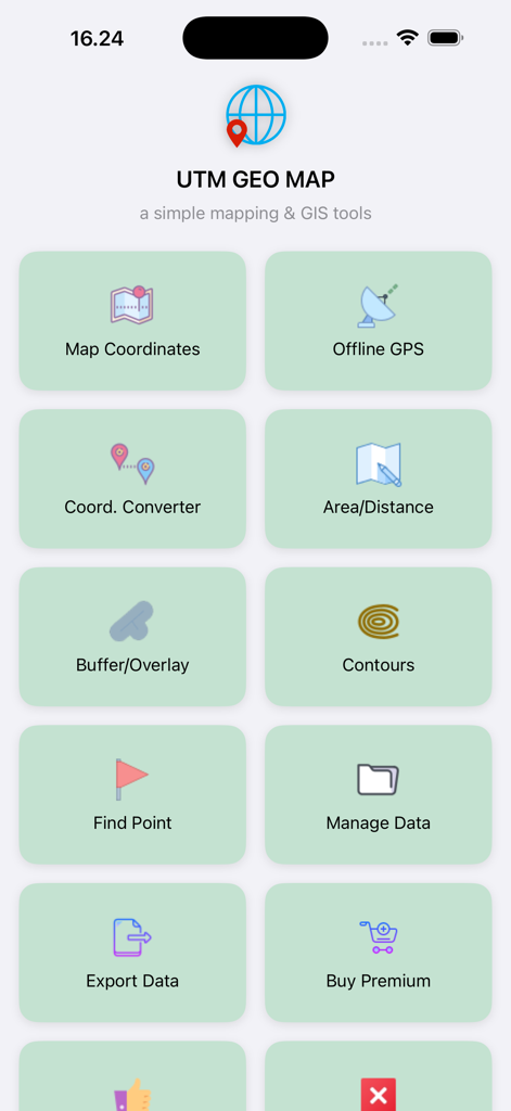
プロフェッショナルGISおよび土地測量ツールモジュールを表示するUTM Geo Mapアプリのメインメニュー
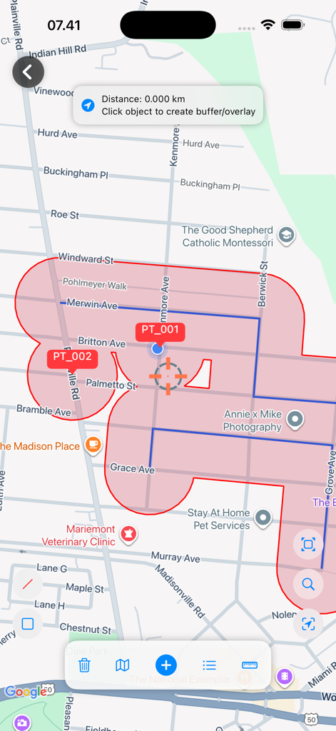
モバイルGISインターフェースに、通りの地図上に赤いバッファゾーンと空間分析が表示されています
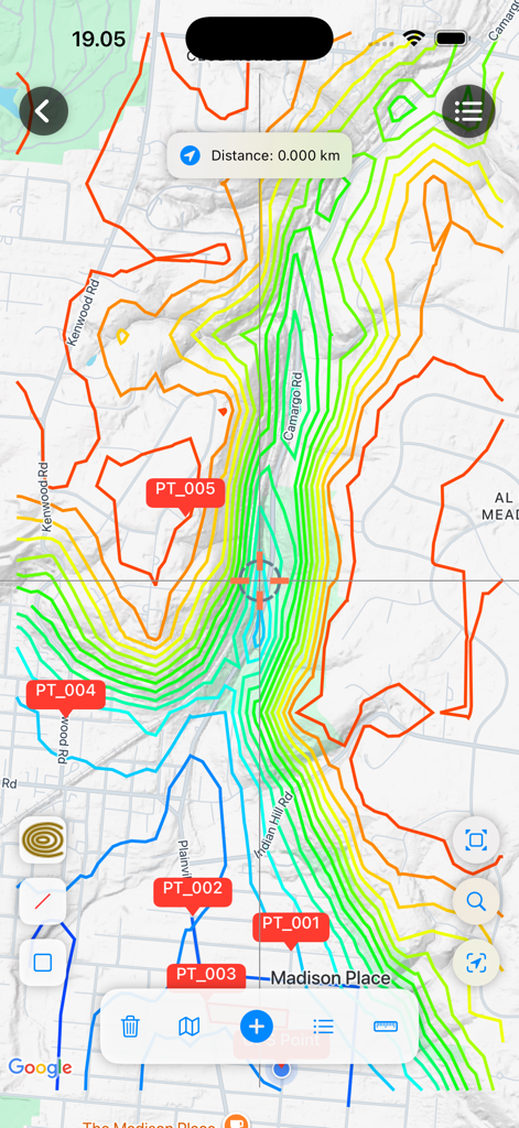
UTM Geo Mapインターフェースに地形等高線と測量ポイントが表示されています
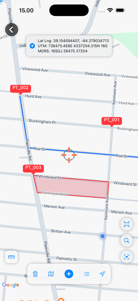
UTM Geo Mapインターフェースに、UTMおよびMGRS座標を持つ土地測量マーカーと面積ポリゴンが表示されています
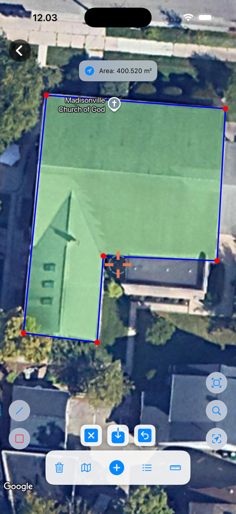
UTM Geo Mapアプリの衛星ビューに、建物のポリゴン面積測定が表示されています
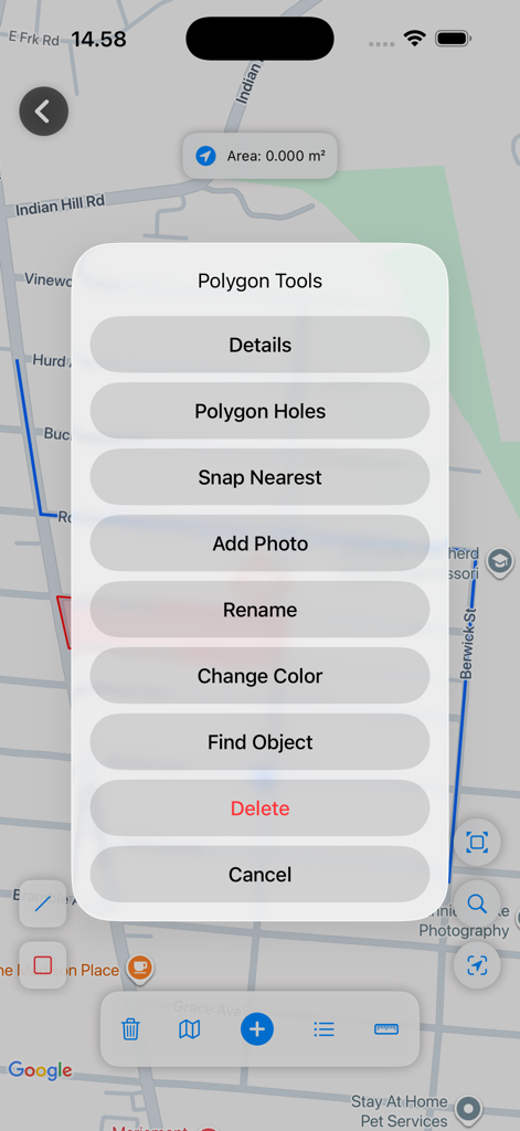
マッピングオプションを備えたUTM Geo Mapアプリインターフェースのポリゴーツールメニュー
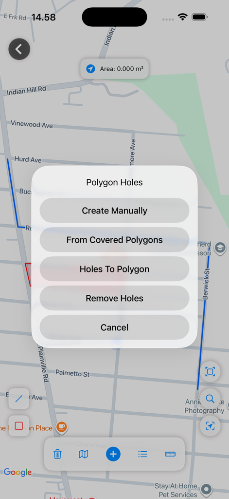
UTM Geo Map測量アプリケーションのポリゴン穴メニューオプション
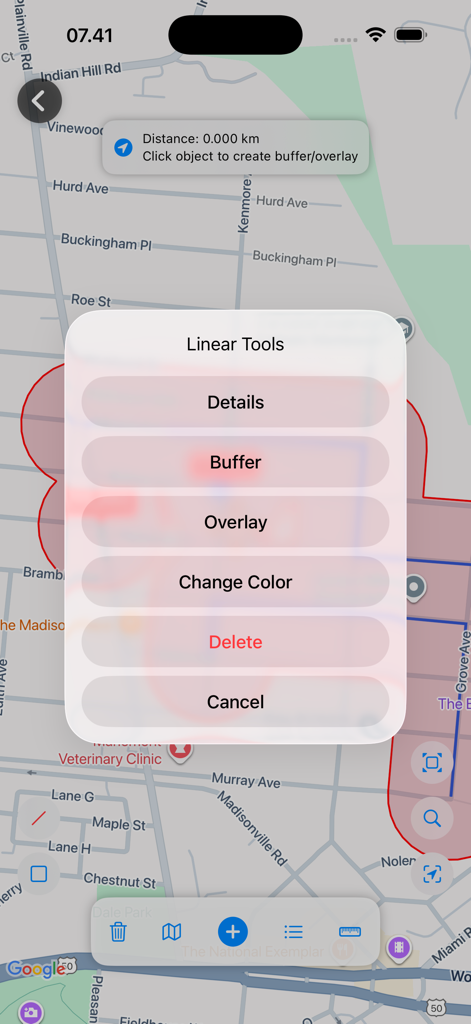
UTM Geo Mapインターフェースに、通りの地図上にバッファやオーバーレイなどの線形GISツールが表示されています。
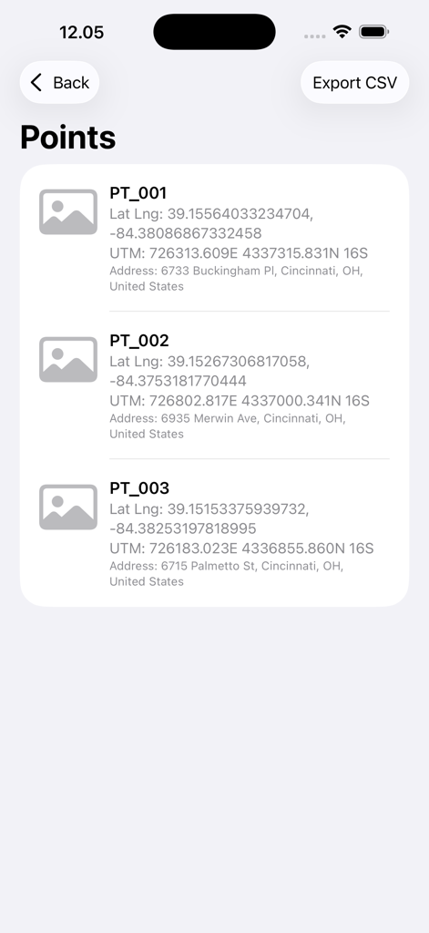
UTMおよび緯度経度座標を表示する登録された地理ポイントのリスト

プロフェッショナルな杭打ちタスクのターゲット座標と距離を示すナビゲーション画面
説明
Download
類似アプリ
同じカテゴリのトップランクアプリ

Google Maps
Google LLC

Waze Navigation & Live Traffic
waze

AMap Global
AutoNavi Information Technology Co. Ltd.

百度地图-路线规划,出行必备
Beijing Baidu Netcom Science & Technology Co.,Ltd

Moovit: Bus & Transit Tracker
Moovit App Global LTD

Transit • Subway & Bus Times
9280-0366 Quebec inc.

ParkMobile: Park. Pay. Go.
Parkmobile USA, Inc

腾讯地图-路线规划,导航地铁打车出行
Shenzhen Tencent Computer Systems Company Limited

Île-de-France Mobilités
Ile de France Mobilites
このページはアプリまたはその開発者の公式ページではなく、情報提供および論評を目的として作成された独立した編集出版物です。明示的に別段の記載がない限り、アプリおよびその開発者は、MWM、Apple、Google Play、アプリのパブリッシャー、またはアプリの開発者と提携、承認、後援、認可、またはその他の公式的な関係はなく、このページのいかなる内容も、アプリがMWMのサービスを使用して開発されたことを意味するものではありません。すべての商標、ロゴ、スクリーンショット、その他のコンテンツはそれぞれの所有者の財産です。