このページはアプリまたはその開発者の公式ページではなく、情報提供および論評を目的として作成された独立した編集出版物です。明示的に別段の記載がない限り、アプリおよびその開発者は、MWM、Apple、Google Play、アプリのパブリッシャー、またはアプリの開発者と提携、承認、後援、認可、またはその他の公式的な関係はなく、このページのいかなる内容も、アプリがMWMのサービスを使用して開発されたことを意味するものではありません。すべての商標、ロゴ、スクリーンショット、その他のコンテンツはそれぞれの所有者の財産です。

Yorkshire Three Peaks
ヨークシャー・スリー・ピークスは、単なる地図アプリではない。これは、地域の自然を尊重し、安全に冒険するための、あなたの個人的な現地ガイドだ。
ダウンロード
10k+ユーザー評価
評価数
133開発元
カテゴリ
Travel対応言語
1最新バージョン
1.7サイズ
32.9 MBリリース日
2013年9月11日テックアナリストによる詳細評価とユーザーインパクトスコア
Yorkshire Three Peaksアプリの機能分析
包括的な安全情報と行動規範
このアプリには、ハイキング中の安全を確保し、地域のコミュニティを保護するための重要な安全に関するアドバイスと行動規範が含まれています。ユーザーは予期せぬ状況に備え、責任ある行動をとるための知識を得ることができます。
GPSルート追跡と進捗表示
このGPS対応アプリは、選択したルートに沿って矢印で案内し、現在地とルート上の進行状況を示します。ユーザーは迷うことなく安心してハイキングを進めることができます。
クラシックなスリーピークス挑戦ルート
本アプリは、ヨークシャー・スリーピークス挑戦の象徴であるクラシックな24マイル周回ルートの詳細な情報を提供します。野心的なハイカーは、この挑戦を計画し実行するための重要なガイダンスを得ることができます。
個別ピークの登頂ルート
本ツールは、Whernside、Pen-y-ghent、Ingleboroughといった個々のピークへのルートマップをユーザーに提示します。カジュアルなウォーカーや特定のピークに焦点を当てたいユーザーは、目標に合わせたルート選択が可能です。
国立公園レンジャー監修の地域情報
本アプリは、ヨークシャー・スリーピークスの国立公園レンジャーによって開発され、ルート沿いの興味深い地点に関する情報が含まれています。ユーザーは地域の自然、歴史、文化について深く学ぶことができ、ハイキング体験がより豊かなものになります。
周辺地域の短い散策ルート
このアプリは、スリーピークスエリア内の4つの短い散策ルートに関する情報も提供します。ユーザーは日帰り訪問や家族連れでも楽しめる、より手軽なアウトドア体験を選択できます。
以下のスクリーンショットと説明は、アプリの公式ストアリスティングから直接取得されたものであり、アプリ開発者の所有物です。
アプリストア
スクリーンショット

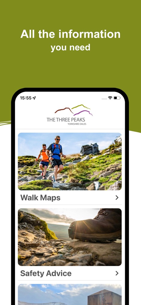
この画面では、美しく広がる谷の空中写真と、それぞれのピークが記載されたカードでルートの概要が提供されます。
主要ルートを探索
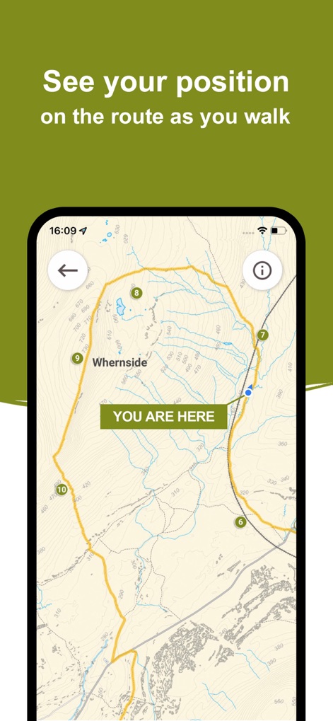
ユーザーは、ルート上の現在地を示す青いドットと、道中の重要な地点を示す番号付きマーカーを確認できます。
現在地を追跡

このアプリは、特定の地点の詳細な説明を含む情報ポップアップと、地形の高低を示す等高線を提供します。
豆知識を発見
本ツールは、壮大なハイキングコースの風景写真と、ハイカーにとって不可欠な安全アドバイスのセクションを備えています。
万全の準備
説明
Download
類似アプリ
同じカテゴリのトップランクアプリ

Uber - Request a ride
Uber Technologies, Inc.

Airbnb
Airbnb, Inc.

铁路12306
ACADEMY OF RAILWAY SCIENCES CO., ltd.

Booking.com: Hotels & Travel
Booking.com B.V.

Grab: Taxi Ride, Food Delivery
GRABTAXI HOLDINGS PTE. LTD.

Trip.com: Book Flights, Hotels
Trip.com Travel Singapore Pte. Ltd.

DiDi China: Ride Hailing
Didi Chuxing (Beijing) Network Platform Technology Co., Ltd

去哪儿旅行-订酒店机票火车票
Beijing Qunar Information Technology Company Limit

Bolt: Request a Ride
BOLT TECHNOLOGY OU
このページはアプリまたはその開発者の公式ページではなく、情報提供および論評を目的として作成された独立した編集出版物です。明示的に別段の記載がない限り、アプリおよびその開発者は、MWM、Apple、Google Play、アプリのパブリッシャー、またはアプリの開発者と提携、承認、後援、認可、またはその他の公式的な関係はなく、このページのいかなる内容も、アプリがMWMのサービスを使用して開発されたことを意味するものではありません。すべての商標、ロゴ、スクリーンショット、その他のコンテンツはそれぞれの所有者の財産です。