이 페이지는 앱이나 개발자의 공식 페이지가 아니며, 정보 제공 및 논평을 목적으로 작성된 독립 편집 간행물입니다. 명시적으로 달리 언급되지 않는 한, 해당 앱이나 개발자는 MWM, Apple, Google Play, 앱 퍼블리셔 또는 앱 개발자와 제휴, 보증, 후원, 승인 또는 공식적으로 연결되어 있지 않으며, 이 페이지의 어떤 내용도 해당 앱이 MWM의 서비스를 사용하여 개발되었음을 의미하지 않습니다. 모든 상표, 로고, 스크린샷 및 기타 콘텐츠는 해당 소유자의 자산입니다.

AirNav Radar – Flight Tracker
36,000개 이상의 수신기로 구성된 당사의 글로벌 네트워크를 사용하여 수백만 명의 항공 애호가 및 전문가와 함께 항공편을 추적하고, 실시간 ATC 무선 통신을 듣고, 비교할 수 없는 정밀함으로 전문가 수준의 비행 데이터에 액세스하세요.
다운로드
1M+사용자 평점
총 평가 수
3K+개발사
카테고리
Travel지원 언어
1최신 버전
3.2.4크기
137.9 MB출시일
2018년 7월 28일전문가 수준의 비행 정보
36,000개 이상의 ADS-B 수신기 글로벌 네트워크로 구동되는 가장 정확한 실시간 데이터를 사용하는 백만 명 이상의 항공 애호가 및 전문가와 함께하세요.
타의 추종을 불허하는 글로벌 정확도
ADS-B, 위성 및 해양 센서의 다중 소스 데이터를 사용하여 실시간 고도, 속도 및 위치 업데이트로 항공편을 정밀하게 추적하세요.
실시간 ATC 및 관제탑 무전
전 세계 관제탑에서 송신되는 실시간 무전 통신을 들으며 조종석에 앉은 듯한 경험을 해보세요. 진지한 항공 애호가라면 필수적인 기능입니다.
자주 묻는 질문
에 대해 알아야 할 모든 것 AirNav Radar – Flight Tracker
AirNav Radar – Flight Tracker는 무엇인가요?
AirNav Radar는 전 세계의 정확하고 실시간 항공기 및 항공편 추적을 제공하는 실시간 항공편 추적 앱입니다. 항공 애호가, 여행자, 조종사 및 전문가가 이륙부터 착륙까지 항공기를 추적하는 데 사용됩니다.
AirNav Radar의 항공편 추적은 얼마나 정확한가요?
AirNav Radar는 고정밀 실시간 항공편 데이터를 제공합니다. 36,000개 이상의 수신기, ADS-B, MLAT, 위성 및 해양 소스의 글로벌 네트워크 데이터를 결합하여 가장 정확한 추적기 중 하나입니다.
AirNav Radar는 전 세계적으로 항공편을 추적하나요?
예, AirNav Radar는 포괄적인 글로벌 항공편 추적 기능을 제공합니다. 36,000개 이상의 수신기로 구성된 네트워크는 전 세계 주요 공항과 국제 항공편 경로를 커버하며 육지 및 외딴 지역의 항공편을 추적합니다.
AirNav Radar는 항공편에 대해 어떤 실시간 정보를 제공하나요?
AirNav Radar는 실시간 항공편 위치, 경로, 항공기 사진, 제조사, 모델, 항공사, 고도 및 속도를 제공합니다. 또한 항공편 상태 변경 및 도착/출발 모니터링에 대한 실시간 알림도 제공합니다.
AirNav Radar를 사용하여 과거 항공편을 다시 볼 수 있나요?
예, AirNav Radar를 사용하면 과거 항공편을 다시 볼 수 있습니다. 무료 버전은 최대 7일의 과거 데이터를 제공하며, 광고 없는 요금제는 30일까지, 비즈니스 요금제는 365일까지 확장됩니다.
AirNav Radar는 항공기를 추적하기 위해 어떤 기술을 사용하나요?
AirNav Radar는 다중 소스 추적 접근 방식을 사용합니다. ADS-B 트랜스폰더, MLAT, ASDI, 해양 데이터 및 위성의 데이터를 결합하고 36,000개 이상의 수신기로 구성된 글로벌 네트워크를 활용합니다.
AirNav Radar 광고 없는 요금제의 이점은 무엇인가요?
광고 없는 요금제는 완전히 광고 없는 환경, 실시간 공항 관제탑 라디오 무제한 액세스, 고도 및 속도를 보여주는 전체 비행 그래프, 30일간의 과거 비행 데이터 및 다시 보기 액세스를 제공합니다.
AirNav Radar 조종사 요금제에는 어떤 고급 기능이 포함되어 있나요?
조종사 요금제에는 광고 없는 모든 기능과 고급 항공 도구가 포함됩니다. 여기에는 지형, 위성 및 항공 지도 레이어, 공항 및 경로 날씨 레이어, 고급 비행 및 항공기 필터링이 포함됩니다.
AirNav Radar는 전문적인 사용을 위한 요금제를 제공하나요?
예, AirNav Radar는 비즈니스 요금제를 제공합니다. 이 요금제에는 최대 365일의 과거 데이터, 여러 항공기에 대한 항공편 추적, 상세한 공항 개요, 확장된 원시 비행 데이터 다운로드와 같은 전문 등급 도구가 포함됩니다.
AirNav Radar는 실시간 날씨 조건을 표시할 수 있나요?
예, AirNav Radar 조종사 요금제에는 날씨 레이어가 포함되어 있어 공항 및 전체 항공편 경로에 대한 실시간 날씨 조건을 제공합니다. 이러한 오버레이에는 구름 범위, 강수량 및 바람 표시기가 포함됩니다.
AirNav Radar에 증강 현실 기능이 있나요?
예, AirNav Radar에는 증강 현실 기능이 포함되어 있습니다. 사용자는 카메라를 하늘로 향하게 하여 위에 있는 항공기를 즉시 식별하고 실시간으로 비행 세부 정보를 볼 수 있습니다.
AirNav Radar는 항공기에 대한 상세 정보를 표시할 수 있나요?
예, AirNav Radar는 상세한 항공기 정보를 제공합니다. 여기에는 항공기의 제조사, 모델, 항공사, 등록 번호, 일련 번호, 연식 및 좌석 배치도 구성까지 포함됩니다.
AirNav Radar는 실시간 공항 출발 및 도착 보드를 표시하나요?
예, AirNav Radar는 실시간 항공편 보드를 제공합니다. 사용자는 전 세계 어느 공항의 출발 및 도착을 모니터링하고 각 항공편에 대한 명확한 항공편 상태 업데이트를 볼 수 있습니다.
다음 스크린샷과 설명은 앱의 공식 스토어 목록에서 직접 가져온 것이며 앱 개발자의 자산입니다.
앱 스토어
스크린샷
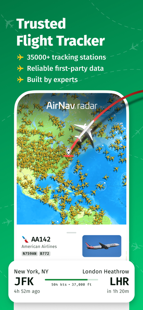
항공기 아이콘과 뉴욕에서 런던으로 가는 아메리칸 항공편의 상세 추적 정보를 보여주는 실시간 세계 지도가 표시된 AirNav 레이더 앱 인터페이스.
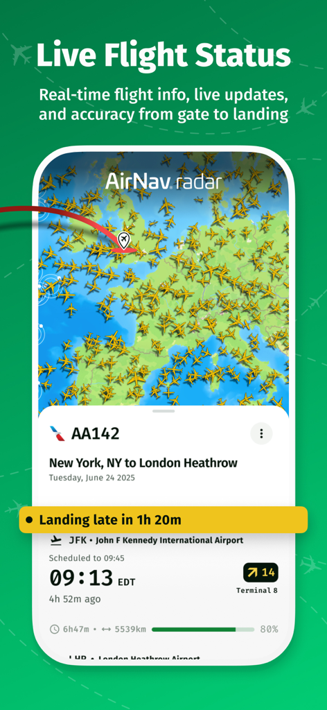
실시간 항공기 지도로 뉴욕에서 런던으로 가는 AA142편의 실시간 비행 상태를 표시하는 AirNav 레이더 앱
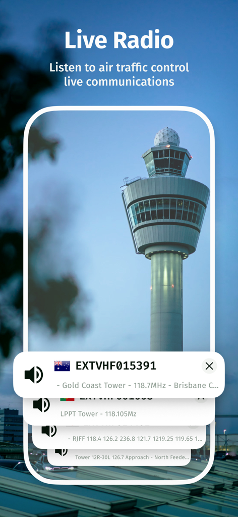
AirNav 레이더 앱의 실시간 항공 교통 관제 무선 통신 기능
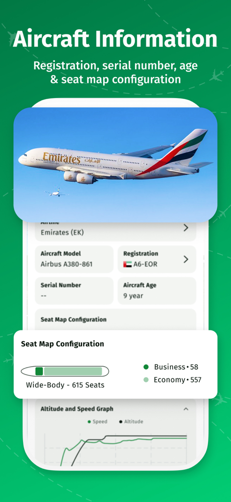
모델 등록 연령 및 에미레이트 항공편의 좌석 배치도 구성을 포함한 상세 항공기 정보를 보여주는 AirNav 레이더 앱 스크린샷
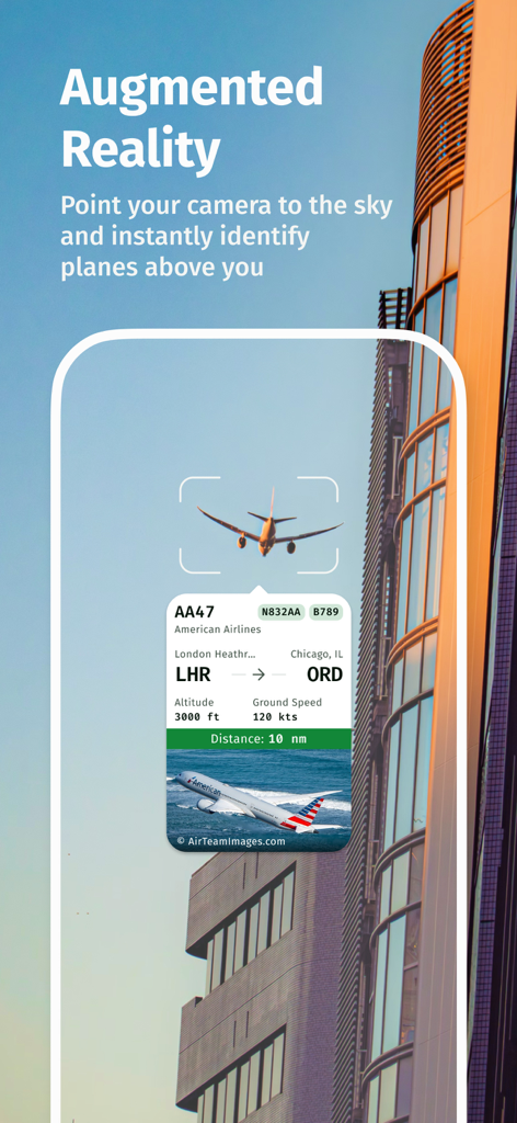
실시간 비행 정보로 하늘의 비행기를 식별하는 AirNav 레이더 앱 증강 현실 기능

흥미로운 비행 찾기 텍스트와 함께 스포터들이 찍은 항공기 사진 그리드
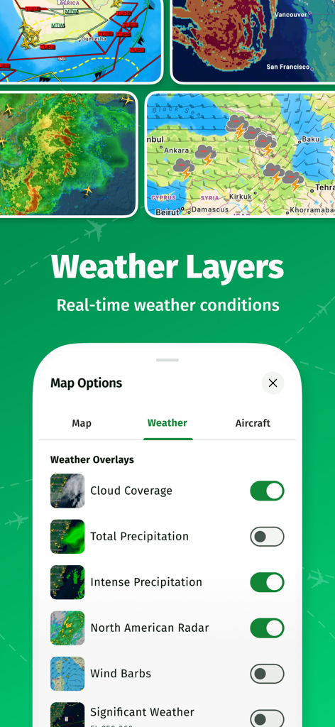
AirNav 레이더 비행 추적기 앱 인터페이스의 실시간 날씨 레이어 및 지도 오버레이 옵션
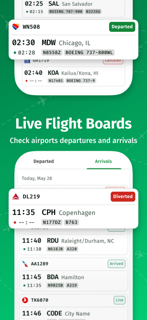
실시간 비행 상태를 보여주는 AirNav 레이더 앱의 실시간 공항 출발 및 도착 게시판

AirNav 레이더 비행 추적기에 대한 항공 전문가의 추천사와 주요 뉴스 매체의 언론 언급
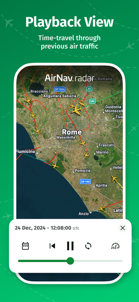
과거 로마 상공의 항공 교통을 재생 보기 기능으로 보여주는 AirNav 레이더 비행 추적기 앱
설명
Download
비슷한 앱
유사한 기능과 사용자 경험을 가진 앱

Flightradar24 | Flight Tracker
Flightradar24 AB

飞常准-航班动态机票购买查询追踪值机
FEEYO.COM E-COMMERCE CORP.

Flighty – Live Flight Tracker
Flighty LLC

Flight Tracker: Plane Radar 24
Oleksandr Vynnyk

FlightStats
LNRS Data Services Limited

AirHelp・Flight Tracker
AirHelp Germany GmbH

Spot the Station
NASA

Flight Tracker & Radar
ISLAND STORM LABS LIMITED

Flight Tracker - Plane Status
Discover Ukraine LLC
이 페이지는 앱이나 개발자의 공식 페이지가 아니며, 정보 제공 및 논평을 목적으로 작성된 독립 편집 간행물입니다. 명시적으로 달리 언급되지 않는 한, 해당 앱이나 개발자는 MWM, Apple, Google Play, 앱 퍼블리셔 또는 앱 개발자와 제휴, 보증, 후원, 승인 또는 공식적으로 연결되어 있지 않으며, 이 페이지의 어떤 내용도 해당 앱이 MWM의 서비스를 사용하여 개발되었음을 의미하지 않습니다. 모든 상표, 로고, 스크린샷 및 기타 콘텐츠는 해당 소유자의 자산입니다.