이 페이지는 앱이나 개발자의 공식 페이지가 아니며, 정보 제공 및 논평을 목적으로 작성된 독립 편집 간행물입니다. 명시적으로 달리 언급되지 않는 한, 해당 앱이나 개발자는 MWM, Apple, Google Play, 앱 퍼블리셔 또는 앱 개발자와 제휴, 보증, 후원, 승인 또는 공식적으로 연결되어 있지 않으며, 이 페이지의 어떤 내용도 해당 앱이 MWM의 서비스를 사용하여 개발되었음을 의미하지 않습니다. 모든 상표, 로고, 스크린샷 및 기타 콘텐츠는 해당 소유자의 자산입니다.

AirTrack Classic
모바일 장치에서 전문가 수준의 MFD, PFD 및 FMC로 시뮬레이터를 생생하게 구현하세요. 장거리 비행을 원격으로 모니터링하고, 자동 조종 장치를 제어하고, MSFS, X-Plane 및 Navigraph와 원활하게 통합하세요.
다운로드
262K+사용자 평점
총 평가 수
400개발사
카테고리
Navigation지원 언어
1최신 버전
3.21크기
188.6 MB출시일
2010년 8월 3일전문가용 비행 데크 통합
모바일 장치를 고충실도 항공 전자 장비 제품군으로 변환하세요. 실제 조종석의 정밀도로 가상 비행을 제어, 모니터링 및 탐색하세요.
무선 비행 모니터링
제어력을 잃지 않고 책상에서 벗어나세요. 실시간 WiFi 동기화를 통해 집 안 어디에서든 고도, 속도 및 도착 예정 시간을 모니터링하세요.
원격 자동 조종 장치 및 FMC
전용 FMC 인터페이스를 통해 MCP를 조정하고, 라디오를 튜닝하고, 비행 계획을 관리하여 iPad를 기능적인 터치스크린 조종석 패널로 바꾸세요.
다음 스크린샷과 설명은 앱의 공식 스토어 목록에서 직접 가져온 것이며 앱 개발자의 자산입니다.
앱 스토어
스크린샷
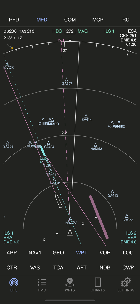
AirTrack Classic 앱 다기능 디스플레이에 비행 내비게이션 및 웨이포인트 표시
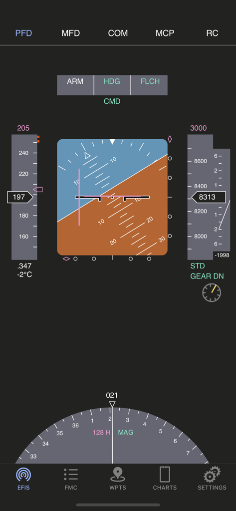
AirTrack Classic 기본 비행 디스플레이 인터페이스에 비행 계기 표시
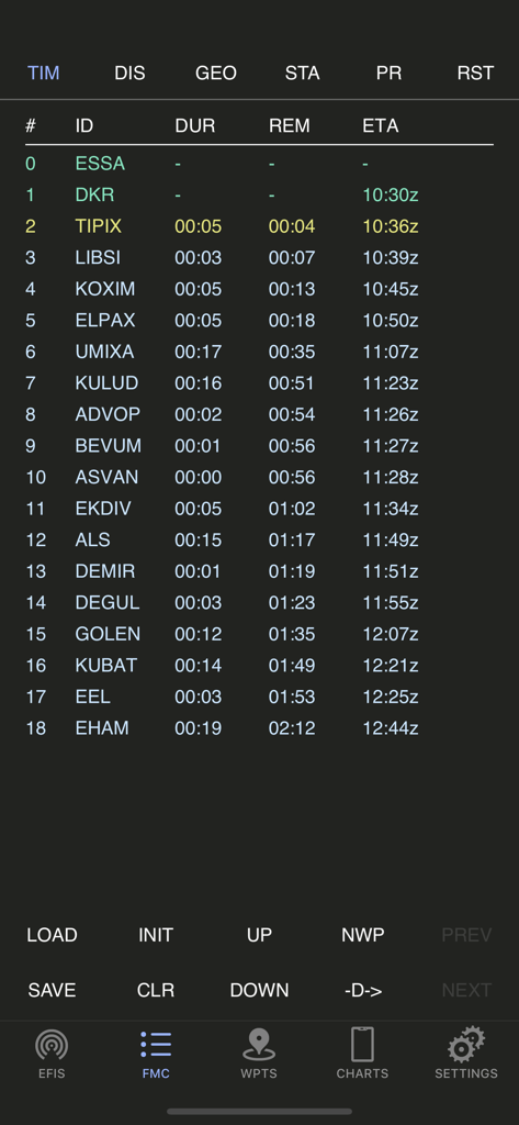
AirTrack Classic 앱에 비행 관리 컴퓨터 경로 플래너 화면 표시
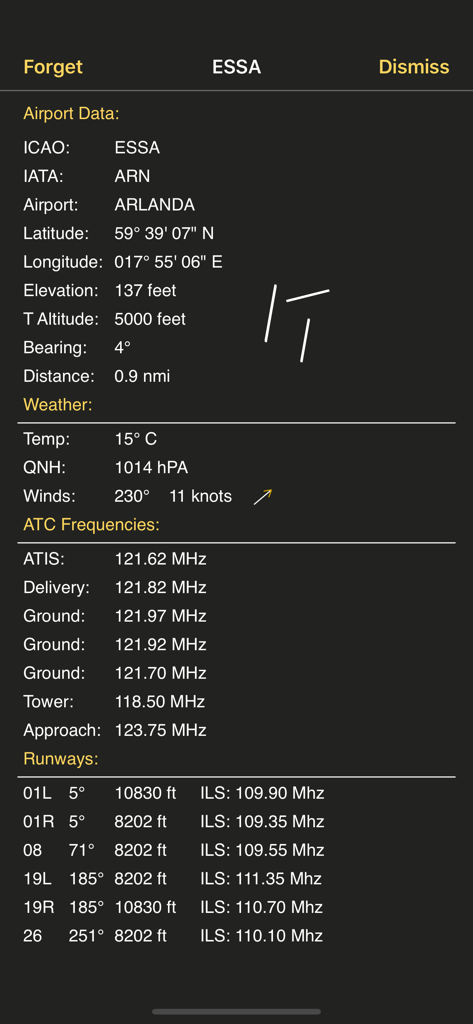
AirTrack Classic 스크린샷에 ESSA Arlanda 공항에 대한 자세한 공항 데이터(날씨, ATC 주파수, 활주로 정보 포함) 표시
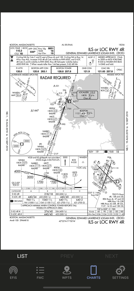
AirTrack Classic 앱에 표시된 보스턴 로건 국제공항 계기 접근 차트.
설명
Download
비슷한 앱
유사한 기능과 사용자 경험을 가진 앱

NBA 2K25 MyTEAM
2K Sports

Planner for AC: NH
Carolin Svensson

fnbr.co — Tracker for Fortnite
Kairu Media Ltd

Warframe Companion
Digital Extremes

VALPAW
Thorben Hamann

战盟-官方社交平台
Chengdu Liwei Network Technology Co., Ltd.

SIM-Dashboard
Christian Hausmann

Career Mode Tracker
Ivo Teixeira

NBA 2K24 MyTEAM
2K Sports
이 페이지는 앱이나 개발자의 공식 페이지가 아니며, 정보 제공 및 논평을 목적으로 작성된 독립 편집 간행물입니다. 명시적으로 달리 언급되지 않는 한, 해당 앱이나 개발자는 MWM, Apple, Google Play, 앱 퍼블리셔 또는 앱 개발자와 제휴, 보증, 후원, 승인 또는 공식적으로 연결되어 있지 않으며, 이 페이지의 어떤 내용도 해당 앱이 MWM의 서비스를 사용하여 개발되었음을 의미하지 않습니다. 모든 상표, 로고, 스크린샷 및 기타 콘텐츠는 해당 소유자의 자산입니다.