이 페이지는 앱이나 개발자의 공식 페이지가 아니며, 정보 제공 및 논평을 목적으로 작성된 독립 편집 간행물입니다. 명시적으로 달리 언급되지 않는 한, 해당 앱이나 개발자는 MWM, Apple, Google Play, 앱 퍼블리셔 또는 앱 개발자와 제휴, 보증, 후원, 승인 또는 공식적으로 연결되어 있지 않으며, 이 페이지의 어떤 내용도 해당 앱이 MWM의 서비스를 사용하여 개발되었음을 의미하지 않습니다. 모든 상표, 로고, 스크린샷 및 기타 콘텐츠는 해당 소유자의 자산입니다.

Alps Peaks AR
인터넷 연결 없이 고급 증강 현실을 사용하여 20,000개 이상의 봉우리를 즉시 식별하고 주변 대피소, 호수, 트레일을 찾아보세요. 고산 모험을 위한 최고의 솔루션입니다.
다운로드
79K+사용자 평점
총 평가 수
0개발사
카테고리
Travel지원 언어
9최신 버전
1.4크기
41.7 MB출시일
2014년 10월 12일알프스 지평선을 정복하세요
현지인처럼 자신감을 가지고 유럽 알프스를 탐색하세요. 당사의 증강 현실 기술은 국제 탐험가들의 지식 격차를 해소하여 모든 풍경을 데이터가 풍부한 경험으로 바꿔줍니다.
즉각적인 봉우리 정보
7개 국가의 20,000개 이상 봉우리를 즉시 식별하세요. 카메라를 향하면 실시간으로 풍경 위에 이름, 고도, 거리가 표시됩니다.
100% 오프라인 안정성
비싼 국제 로밍 요금과 데이터 끊김 현상을 없애세요. 모든 봉우리, 지도, 관심 지점은 트레일에서 완벽한 독립성을 위해 로컬에 저장됩니다.
다음 스크린샷과 설명은 앱의 공식 스토어 목록에서 직접 가져온 것이며 앱 개발자의 자산입니다.
앱 스토어
스크린샷
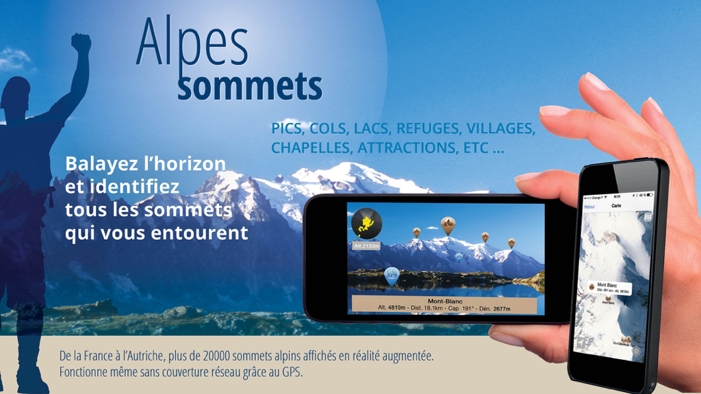
알프스 봉우리 AR 앱 마케팅 이미지로, 스마트폰에서 증강 현실 산 봉우리 식별 및 오프라인 2D 지도를 보여줍니다.
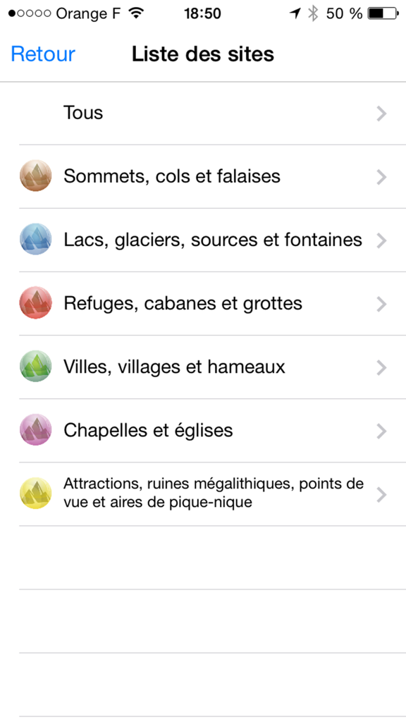
알프스 봉우리 AR 앱에서 봉우리, 호수, 대피소와 같은 산악 관심 지점 범주를 나열하는 메뉴 화면
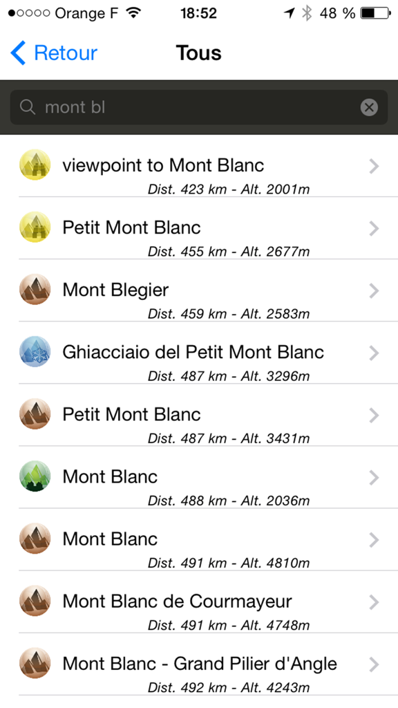
알프스 봉우리 AR 앱에서 거리와 고도가 표시된 몽블랑 검색 결과 목록
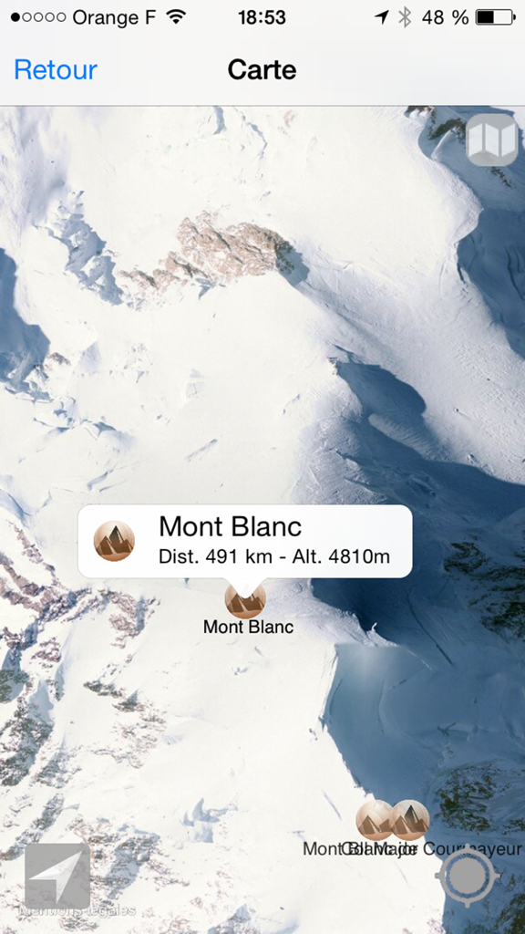
알프스 봉우리 AR 앱에서 고도와 거리가 표시된 몽블랑 위성 지도 보기.
설명
Download
비슷한 앱
같은 카테고리의 상위 앱

Uber - Request a ride
Uber Technologies, Inc.

Airbnb
Airbnb, Inc.

铁路12306
ACADEMY OF RAILWAY SCIENCES CO., ltd.

Booking.com: Hotels & Travel
Booking.com B.V.

Grab: Taxi Ride, Food Delivery
GRABTAXI HOLDINGS PTE. LTD.

Trip.com: Book Flights, Hotels
Trip.com Travel Singapore Pte. Ltd.

DiDi China: Ride Hailing
Didi Chuxing (Beijing) Network Platform Technology Co., Ltd

去哪儿旅行-订酒店机票火车票
Beijing Qunar Information Technology Company Limit

Bolt: Request a Ride
BOLT TECHNOLOGY OU
이 페이지는 앱이나 개발자의 공식 페이지가 아니며, 정보 제공 및 논평을 목적으로 작성된 독립 편집 간행물입니다. 명시적으로 달리 언급되지 않는 한, 해당 앱이나 개발자는 MWM, Apple, Google Play, 앱 퍼블리셔 또는 앱 개발자와 제휴, 보증, 후원, 승인 또는 공식적으로 연결되어 있지 않으며, 이 페이지의 어떤 내용도 해당 앱이 MWM의 서비스를 사용하여 개발되었음을 의미하지 않습니다. 모든 상표, 로고, 스크린샷 및 기타 콘텐츠는 해당 소유자의 자산입니다.